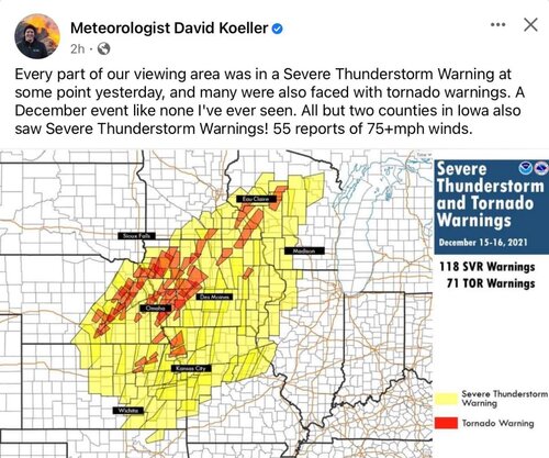
I'm making a thread for this day partially based on my personal experience when I chased and also to include some other information. I'm sure many of you outside of this area aren't aware of what a rare and incredible outbreak of tornadoes and severe weather occurred this day. Last I saw there were over 60 reports of tornadoes in one day in the upper Midwest in December!
I watched this day/setup for probably a good week (torture!), and found it hard to believe what I was seeing forecast for eastern Nebraska into Iowa. Temps 70+ degrees, dews 55-60, and insane speed and directional shear with a LLJ of 70-80 kts. It looked like an April setup vs something in the middle of December. Biggest issue would be possible minimal CAPE and clouds ruining any chance of instability. Once the NAM came into range it initially kept temps in the upper 40s and low 50s with low clouds and so I was worried a bit.
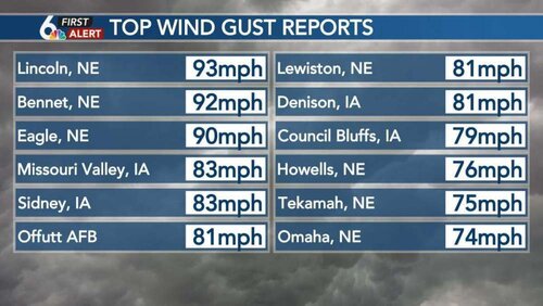
The other aspect of this storm regardless of severe weather potential was high winds. High wind warnings were issued from Texas all the way to Minnesota and Wisconsin which is what I know probably impacted most of us here. Here in eastern Nebraska we had a high wind warning for wind gusts up to 75 mph and some of the models were even showing 90 mph winds right behind the dry line/cold front. Our schools here in Omaha entirely closed for the day, as did Lincoln, and many other smaller schools in the region.
The SPC initially showed no outlook for this day until finally on day 3 there was a rare second outlook issued that placed a marginal risk in the area. This was soon upgraded to a slight on day 2, but then went to a moderate risk on the first day 1 outlook with 10% tornado and 45% hatched wind areas. The moderate risk area was eventually pulled back west to eastern Nebraska and the tornado risk went 10% hatched and the wind stayed 45% hatched with gusts up to 100 mph mentioned in the discussion.
This is Nebraska and Iowa on December 15th right?!!
So I knew I would go chasing, but the crappy part about this setup would be the expected storm motions which were forecast to be 80-90 mph! I've never chased storms moving that fast and figured I would only get one chance to be in the right spot as they raced on by me.
The morning of the 15th was sunny and "humid". CAPE wasn't going to be an issue as it was now forecast to be over 1000 in the warm sector. Felt like a spring day for sure with gusty south winds. Temps were well into the 60s by mid morning and in fact here in Omaha we broke the record high for the day of 61 at 830 am. Dews were also creeping up towards 60 degrees. By mid afternoon, Omaha broke it's all time December record high with a temp of 74 degrees. This is the 2nd time this month we've hit 70 when we had only hit 70+ in December 3x the previous 135 years!!
I left Omaha about 1230 and went up to Missouri Valley along I-29. I was debating whether to stay further east into Iowa where the helicity tracks consistently had been showing up or further west to catch the storms earlier. Not to mention having to deal with it getting dark by 5p. Models kept pulling the development back to the southwest and sure enough by 1p storms formed along the south central NE/KS border and started racing northeast. A tornado watch was issued shortly thereafter until 8p.
Almost immediately the line of storms started having tornado warnings issued and a confirmed tornado or two based on radar. I made myself wait a bit longer and soon the focused area of tornado warnings was on the northeast section of the line that was racing towards Columbus, NE area at 80 mph.
I figured this would be my play so I started west to meet the line as it came up from the southwest. I was watching velocity scans and ended up by a town called Snyder, NE. At this point the line was almost on top of me as I pulled off the highway just west of town. It was crazy to see such a mean looking storm and constant lightning in December.... in Nebraska.
I had my dash cam going and was recording with my phone. There was a notch on the leading edge of the gust front that seemed to be spinning and sure enough right as it crossed the highway started lowering. Once across the highway and over the farm fields you could see dust starting to rotate a bit and get sucked up into the lowering. The darn thing was racing so fast north that it soon vanished behind the rain and at my location the winds really picked up. I recorded a 79 mph gust on my anemometer and a bit of pea sized hail. Lasted not even 5 minutes.
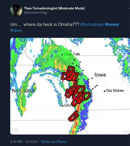
I looked at radar back to my south and now the well developed line to my south was racing towards Omaha where my wife and kids were at home and it was starting to have tornado warnings as well. They were all in the basement as the sirens went off in Omaha bc of the severe tstorm warning issued for wind gusts up to 90 mph. A tornado warning was issued for just west of town and then just south and north of town. Several confirmed tornadoes came out of the storms in these areas, but nothing in Omaha itself thankfully.
I had a feeble attempt to try and intercept the storms again near Missouri Valley as they raced up from the southwest, but they easily beat me across highway 30 and soon it was dark anyway so I started back home.
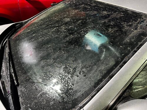
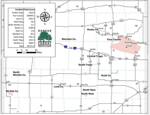
I stopped back in Missouri Valley at a gas station where it began to rain lightly. Sitting in my car, eating a Snickers bar I noticed that my windshield began to get really dirty/muddy. The rain falling was now bringing down all the dust in the atmosphere that had blown in from Kansas and Colorado! Back in Omaha, people could smell smoke in the air which led to dozens of 911 calls for a possible fire, but people weren't seeing any flames. This was because of the large fire in Kansas. There were reports of people smelling smoke in the air all the way to Wisconsin and Illinois!
The NWS offices started doing their surveys of damage and it's been an incredible number of tornadoes confirmed. The majority have been EF-2's, but thankfully most were very short lived so damage has been minimal with no loss of life directly connected to the tornadoes that I have seen.
Here's some graphics and info I've saved from the event.
First here's my dash cam footage of the tornado forming near Snyder. This has been confirmed by survey as being an EF-1.
Survey page for Omaha NWS: Severe Storms, Tornadoes, Strong Winds, and Record High Temperatures of December 15, 2021
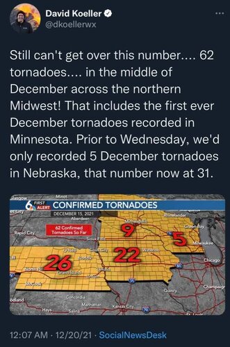
OAX found 3 more tornado tracks yesterday too!!
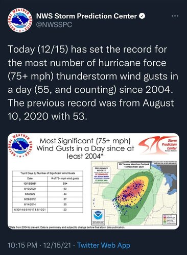
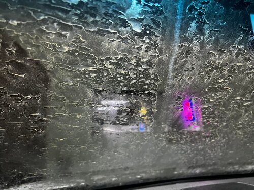
Dirty rain!!


I watched this day/setup for probably a good week (torture!), and found it hard to believe what I was seeing forecast for eastern Nebraska into Iowa. Temps 70+ degrees, dews 55-60, and insane speed and directional shear with a LLJ of 70-80 kts. It looked like an April setup vs something in the middle of December. Biggest issue would be possible minimal CAPE and clouds ruining any chance of instability. Once the NAM came into range it initially kept temps in the upper 40s and low 50s with low clouds and so I was worried a bit.
The other aspect of this storm regardless of severe weather potential was high winds. High wind warnings were issued from Texas all the way to Minnesota and Wisconsin which is what I know probably impacted most of us here. Here in eastern Nebraska we had a high wind warning for wind gusts up to 75 mph and some of the models were even showing 90 mph winds right behind the dry line/cold front. Our schools here in Omaha entirely closed for the day, as did Lincoln, and many other smaller schools in the region.
The SPC initially showed no outlook for this day until finally on day 3 there was a rare second outlook issued that placed a marginal risk in the area. This was soon upgraded to a slight on day 2, but then went to a moderate risk on the first day 1 outlook with 10% tornado and 45% hatched wind areas. The moderate risk area was eventually pulled back west to eastern Nebraska and the tornado risk went 10% hatched and the wind stayed 45% hatched with gusts up to 100 mph mentioned in the discussion.
This is Nebraska and Iowa on December 15th right?!!
So I knew I would go chasing, but the crappy part about this setup would be the expected storm motions which were forecast to be 80-90 mph! I've never chased storms moving that fast and figured I would only get one chance to be in the right spot as they raced on by me.
The morning of the 15th was sunny and "humid". CAPE wasn't going to be an issue as it was now forecast to be over 1000 in the warm sector. Felt like a spring day for sure with gusty south winds. Temps were well into the 60s by mid morning and in fact here in Omaha we broke the record high for the day of 61 at 830 am. Dews were also creeping up towards 60 degrees. By mid afternoon, Omaha broke it's all time December record high with a temp of 74 degrees. This is the 2nd time this month we've hit 70 when we had only hit 70+ in December 3x the previous 135 years!!
I left Omaha about 1230 and went up to Missouri Valley along I-29. I was debating whether to stay further east into Iowa where the helicity tracks consistently had been showing up or further west to catch the storms earlier. Not to mention having to deal with it getting dark by 5p. Models kept pulling the development back to the southwest and sure enough by 1p storms formed along the south central NE/KS border and started racing northeast. A tornado watch was issued shortly thereafter until 8p.
Almost immediately the line of storms started having tornado warnings issued and a confirmed tornado or two based on radar. I made myself wait a bit longer and soon the focused area of tornado warnings was on the northeast section of the line that was racing towards Columbus, NE area at 80 mph.
I figured this would be my play so I started west to meet the line as it came up from the southwest. I was watching velocity scans and ended up by a town called Snyder, NE. At this point the line was almost on top of me as I pulled off the highway just west of town. It was crazy to see such a mean looking storm and constant lightning in December.... in Nebraska.
I had my dash cam going and was recording with my phone. There was a notch on the leading edge of the gust front that seemed to be spinning and sure enough right as it crossed the highway started lowering. Once across the highway and over the farm fields you could see dust starting to rotate a bit and get sucked up into the lowering. The darn thing was racing so fast north that it soon vanished behind the rain and at my location the winds really picked up. I recorded a 79 mph gust on my anemometer and a bit of pea sized hail. Lasted not even 5 minutes.
I looked at radar back to my south and now the well developed line to my south was racing towards Omaha where my wife and kids were at home and it was starting to have tornado warnings as well. They were all in the basement as the sirens went off in Omaha bc of the severe tstorm warning issued for wind gusts up to 90 mph. A tornado warning was issued for just west of town and then just south and north of town. Several confirmed tornadoes came out of the storms in these areas, but nothing in Omaha itself thankfully.
I had a feeble attempt to try and intercept the storms again near Missouri Valley as they raced up from the southwest, but they easily beat me across highway 30 and soon it was dark anyway so I started back home.
I stopped back in Missouri Valley at a gas station where it began to rain lightly. Sitting in my car, eating a Snickers bar I noticed that my windshield began to get really dirty/muddy. The rain falling was now bringing down all the dust in the atmosphere that had blown in from Kansas and Colorado! Back in Omaha, people could smell smoke in the air which led to dozens of 911 calls for a possible fire, but people weren't seeing any flames. This was because of the large fire in Kansas. There were reports of people smelling smoke in the air all the way to Wisconsin and Illinois!
The NWS offices started doing their surveys of damage and it's been an incredible number of tornadoes confirmed. The majority have been EF-2's, but thankfully most were very short lived so damage has been minimal with no loss of life directly connected to the tornadoes that I have seen.
Here's some graphics and info I've saved from the event.
First here's my dash cam footage of the tornado forming near Snyder. This has been confirmed by survey as being an EF-1.
Survey page for Omaha NWS: Severe Storms, Tornadoes, Strong Winds, and Record High Temperatures of December 15, 2021

OAX found 3 more tornado tracks yesterday too!!


Dirty rain!!
