State of the Chase Season 2024

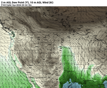
Will be arm chair chasing the possible event(s) this weekend into next week as it's too early for me to head out and I have other obligations. I'm also not completely sold on adequate RH return yet. To the point, it WILL be very interesting to observe how the strong W/SW winds react with the bone dry dust in the western parts of NM and Texas, including the burn scars. In past drought years, we've seen these early-season events plagued by very low visibility behind (of course) and quite a distance east of the dryline.dry-city.png
 
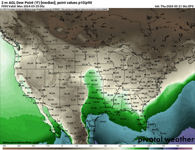
There continues to be moisture issues ahead of this weekends system. Despite a nice trough ejection, the Gulf low and a second reinforcing cold front look to really limit the window for sustained return flow. Multiple ensemble solutions (EPS pictured) have median dewpoints only in the upper 40s to low 50s F. Even then, the quality of those 50s is probably poor. Things get a bit more interesting into the new week across the Southeast but chaseability looks low.
1711034112241.png

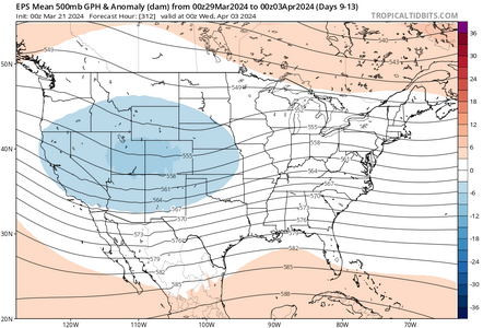
Looking ahead the overall pattern remains amplified. We may be able to squeeze an event or two out but this early in the return flow year the shorter wave-length systems tend to limit moisture. Should have a better idea of the chasing situation heading into early April in the coming days.

1711034871555.png
 
Looking at FEB vs. MAR Forecasts, looks like the Prob trend of AMJ(Neutral) MJJ(Neutral and La Nina) bumped up slightly, while JJA La Nina Prob increased 5 or 6%, so maybe a slightly quicker transition period? but an increased overall prob confidence in La Nina by July/Aug.

1711457968236.png
1711458175715.png
 
Last edited:
Looking at FEB vs. MAR Forecasts, looks like the Prob trend of AMJ(Neutral) MJJ(Neutral and La Nina) bumped up slightly, while JJA La Nina Prob dropped 5 or 6%, so maybe a slightly slower transition period? but an increased overall prob confidence in La Nina by July/Aug.

View attachment 24717
View attachment 24718
Thanks for posting this Jason, although forgive me but it looks to me that all 3-month periods appear to have an increased chance of La Nina in the March forecasts vs February.
 
Really quick, I wanted to share a useful tool I've been using with some of the sub seasonal stuff. This jet phase diagram from U Albany gives us some hints about the overall state of the north Pacific Jet which can be quite influential for the upper air pattern over the western and central CONUS. (Link to paper about the NPJ Diagram)
1711464022849.png

This is a GEFS Based phase diagram based on 2x EOFs (Empirical Orthogonal Functions) that help detrend data and allow it to be sorted into similar behaving regimes. Think of this like the phase diagrams with the MJO. Like the work Dr. Gensini from NIU has done on AAM and the MJO related to severe, this tool is another way to visualize some of those processes. Jet extensions (unusually strong westerly components of pacific jets) help to build large-scale positive angular momentum anomalies in the northern Hemisphere. Think of that +AAM state as potential energy in the jet stream. Once it reaches a certain threshold that system becomes unstable and can "break down". Doing so lowers the AAM state and can result in a wavier upper-air pattern over the western and central US. Those patterns have been historically linked to more active stretches of severe weather potential during the spring.

Another important aspect of these plots is the poleward/equatorward displacement. like the names suggests, this tells you the latitude of the relative anomaly. Equatorward being displaced south and vice versa. Research has shown that when the AAM state begins to fall (Jet Retraction phase) and it is displaced south (equatorward shift) Medium-range model guidance errors become larger and predictability of 500 mb heights, MSLP and precipitation forecasts over the CONUS decreases. (Link to paper) If you've been watching the medium and long range guidance closely, you may have noticed more flip flopping than normal. We appear to be entering a period of lower predictability heading into April.
 
@adlyons - because I can't link to the paper at the moment for some reason, I am behind a firewall that won't let me go to it. Where is the centroid of PC1/PC2 diagram geographically?
 
I did a quick scan and found this....

"A traditional EOF analysis (Wilks 2011, chapter 12) is subsequently performed on the 250-hPa zonal wind anomaly data2 within a horizontal
domain bounded in latitude from 10 to 80N and in longitude from 100E to 120W in order to identify the two leading modes of NPJ variability. This horizontal domain is chosen to encompass the North Pacific basin and to match the domain employed by Griffin and Martin (2017)."

Not sure if that helps.
 
Thanks for that Mark, I think, (mistakenly perhaps), when I was looking at the diagram, the grid could be attached to a particular LAT/LONG area within that 10-80 & 100E-120W. for example, if PC1 = -1 & PC2 = -1 (than insert that -1 and -1 = (insert LAT/LONG) and I can look on a map and see that grid area. I guess I just wasn't sure if the X and Y's on that diagram were tied to the map on the right.
 
Gotcha.... no worries. I was gonna read the paper in full if I had some free time at work tonight, so I just glanced it over for an obvious answer. I'll try to get back to asap if no one else has posted. Looks like fascinating find as far as teleconnections go. A lot of it is over my head at the moment, but I enjoy the learning process. Thanks for posting that @adlyons!
 
@adlyons - hey just fyi, my "conversations" chat thing will not allow me to type back? I just noticed your message from Feb lol.. didn't even know it was there until today and when I try to respond, it doesn't allow me to send the message. so sorry about that!. I didn't wanna post this here, but I will until you see it, then if it's not too late, I'll erase it.
 
@adlyons - hey just fyi, my "conversations" chat thing will not allow me to type back? I just noticed your message from Feb lol.. didn't even know it was there until today and when I try to respond, it doesn't allow me to send the message. so sorry about that!. I didn't wanna post this here, but I will until you see it, then if it's not too late, I'll erase it.
No worries man!
 
Back
Top