State of the Chase Season 2024

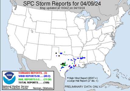
Is it me, or is the SPC having a really tough year to date?

Tornado watch yesterday; zero reports. Tornado watch this morning; zero reports. And, we are seeing "no reports" in 10% hatched areas.

Thoughts?

Just an observation and nothing more, but it seems they have been more aggressive in assigning areas of tornado risk within expected linear events this year as if they're recognizing the QLCS tornado threat a bit more? If it were the case (and I'm not saying it is, like I said just a guess) it would be hard to verify the forecast success rate since most occur so quickly and rarely cause substantial damage.
 
With regard to Lyons' (above map) report, those tornadoes occurred hours after the tornado watch in question expired.

Regarding the map, the tornado northwest of Houston occurred in a severe thunderstorm watch. It wasn't until later a tornado watch was issued.
 
With regard to Lyons' (above map) report, those tornadoes occurred hours after the tornado watch in question expired.

Regarding the map, the tornado northwest of Houston occurred in a severe thunderstorm watch. It wasn't until later a tornado watch was issued.
Once again, info is preliminary. We see red dots fill in several days after events. Judge a forecast not, until all relevant info is available.
 
I've noticed this with a few systems as well and a lot of it seems to be related to moisture overload, excessive debris cloud, and low/mid/high jet orientations modifying the moisture dynamics. it seems that the jet orientations near coastal systems have a fairly fine line of meridional to zonal flows which will create either heavy moisture Linear or QLCS structures, vs. more zonal westerly jets that present just enough EML to change modes rapidly and also decrease the heavier cloud debris from previous days convection, which is what I like to key in on when comparing events like this to the super outbreak in 2011.
 
Last edited:
Is it me, or is the SPC having a really tough year to date?
I think if we are honest, a lot of folks - myself included - are not having the greatest stats this year. But it is early in the season and much like my Texas Rangers who are 9-8 (.529) there is a lot of season left (after all we are only 17 games into the season and have 145 left). It occurred to me during my under preforming chase yesterday in NW Texas that this is a season of persistence and patience. This isn't a season - at least yet- where we get day after day of great setups that produce. We have a year so far that is both similar and unlike the taco watch/warning graphic that explain watch vs warning. Yesterday we had all the ingredients in place but instead of getting a beautiful delicious taco we got a messy plate that looks like my dining room table and floor after my kids eat dinner. I don't fault SPC for issuing a tornado watch yesterday (4/15) in TX. It was the right call. Just a little different and it would have been a much bigger day.

On a side note, my Texas Rangers are leading the AL West, even with just a .529. The AL West isn't pretty. This season isn't pretty for chasers so far. If we give up now, we will miss the big events that will come. You miss 100% of the setups you don't chase.
 
Just looking at the rest of the month from GFS to CFS, it kind of feels like April might come in below average, ( Adlyons will surely fill that in ), but there may be some changes towards the end of the month into early may where SE ridging comes into play and sets up a better SFC and JET level synoptic pattern which "seems" to line with the earlier NMME I posted for May. Only a little more time will tell.
 
I've always considered April 15th as the official start of my chase season and anything captured before then is a kind of bonus. For plains chasers, if you happen to get a chase in February it's a gift, if you get 2-3 chases in March it's a blessing, and although the activity sees an uptick in early April, storm modes can go either way but it's great to just be able to chase consistently. Yesterday was a kind of an official kickoff to the season for me and the slow moving beauty days lay just ahead.
 
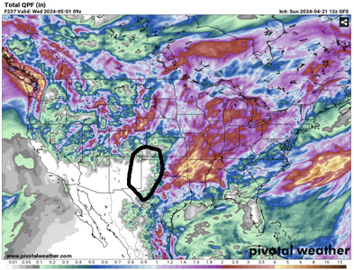
Long rage models are in generally good agreement in keeping western sectors precipitation free for the rest of the month. As previously discussed, this could / will effect dryline placement and create possible visibility issues further east and NE due to dust. Some hits of a change in early May, but I would not count on it ATM.

shot.png
 
I try not to look at long-range models; since my chase trips are largely fixed in time, I would only be torturing myself about missing stuff before I can get out there, or seeing unfavorable indicators for when I can. But yesterday I just happened upon a Tornado Titans video that was bullish on mean southwest flow from late next week into early May. It further noted that it might turn less favorable in mid-May - you know, exactly when my chase trip begins…

Although they did suggest southwest flow would return after a brief lull in mid-May, and that the month looked pretty good overall, perhaps the best since 2018 or 2019.

I haven’t corroborated this with any of my own analysis; for the reasons noted above, I was sorry I even saw this! And of course we all know the long-range outlooks are of dubious value anyway. But sharing this FWIW, and curious as to others’ perspectives.
 
James I don't see anything too concerning on the long-range models or weeklies. Not that they are very valuable past week 3, but it's nice when they don't show a ridge train wreck. They don't.

Before Mother's Day the southwest flow looks to visit off and on. Mother's Day seems like a good dividing day since it's a PDS family day.

After that going into mid-May there's nothing wrong with the pattern, no big Plains ridge or East trough. One could infer split flow, which is just par for the El Nino course. Nino is fading but it'll take a bit. Plus the -TNI also contributes to slop. Still that would allow modest to moderate flow, systems, and chances.

CFS and ECMWF weekly products agree with the above. GEFS weekly, which I don't trust farther than I can throw the rack of servers, is ridgy. Don't worry it's wrong!

State of the Chase Season looks average to me and slightly above average starting this weekend through Mother's Day. Keep in mind Average in late May is still plenty of action.
 
Models are still hinting of favorable westward intrusions of decent RH during the first week of May onward. This, along with favorable upper air configurations via NCEP models, make me increasingly positive about the first week in May+. In other words, the overall outlook would appear to be better than the last few years.
 
Back
Top