State of the Chase Season 2024

It probably depends on where you're at with your chasing journey as well. Given how far I will need to travel, I know well in advance that seeing storms, especially with beautiful structure, will be a win. Tornadoes are the ultimate goal, but if I expect little then I shouldn't be as disappointed if I don't see one.
 
Eyeing the major system forecast to slam into the Plains around the 6-7th. time frame as a starting date. The models are just getting within range to be of some reasonable value. There is agreement in the 126 hr. range of a buzz saw low moving ashore. We know what this could mean for the Plains by the 6-7th. 🌪️⚡⛈️🥃🥩

The only problem is what happens after this event. Some models want to kill things off for at least a week afterwards, with poor RH recovery. I'm not buying that solution ATM.


buzz.png


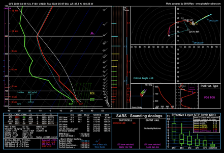
Near Liberal, KS on 4-6-24 at 00z.

Screenshot 2024-04-29 at 10.23.30 AM.png
 
Last edited:
Warren, I have been thinking the same thing as of looking at the models today (was away for the weekend and couldn't catch up until now) - May 6th/7th looks like something will happen though it's fairly up in the air as to where the event will occur (especially for the 7th).

However, as someone who has a chasecation timeframe of May 7-May 15th (with no option to change due to other commitments), I'm becoming really worried about the timeframe beyond May 7th, models are extremely mixed on what could happen - either a series of events, or the moisture gets swept south for a week straight and absolutely nothing happens.

There is so much variation between ECMWF and GFS, and even large variation within run-to-run models of the GFS itself, I have no confidence in it's output. @Warren Faidley - why are you not buying the solution of poor RH recovery? I'm still new to long-range model interpretation so I'm sure I'm missing a lot of nuance behind the current models.
I'm in the same boat as you man. I'm chasing May 6-14. Pumped for the likelihood of a setup on the 6-7, but also very concerned on moisture afterwards. I would love to hear more thoughts about the long range after May 7.
 
@Warren Faidley - why are you not buying the solution of poor RH recovery? I'm still new to long-range model interpretation so I'm sure I'm missing a lot of nuance behind the current models.

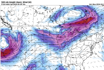
Don't know for sure but the ECEP models do not show any funky blocks or other disruptive patterns like we have seen in recent years. I don't see any synoptic patterns ATM that would push RH to the Yucatan. RH can recover amazingly fast this time of year. A lot will depend on how the "6th" event unfolds.
 
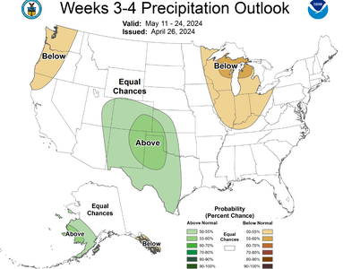
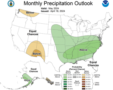
I am not quite sure why these don't seem to line up a bit more considering the temporal coverage is at least.. half of the months forecast below. They were issued on separate dates, so that could be the major reason why I suppose and the missing other half of the month.
1714492121989.png


1714492191173.png
 
Next week could be the time to travel. May 6-10.
Weekdays are favored for safety. Fewer new chasers driving solo while data distracted.

GEFS and EPS, GFS ensembles and ECMWF ensembles, have a Rockies trough and southwest flow next week 6-10 day period. Said models keep a decent pattern in the 11-15 day but the AI artificial intelligence versions do not. In fact the AI goes total opposite ridge West trough East for the 11-15 day. Weekly products also go down the tube by Day 15; so, the AI might be right if the pattern changes quicker right after Mother's Day. This week should have midweek action, but the decision point in time has passed. Therefore I have to favor the upcoming week.

Digging into deterministic and ensemble mid-range, it appears that a new trough will establish in the Rockies next week. Should eject 2-3 short waves. Hopefully it’s less progressive than this week; sits out there, and gives more chase days. SPC appears to favor the Euro over the fickle GFS in their Day 4-8 text. The weather pattern above and instability are mentioned. It’s probably going to be warm at 700 mb, but a few places should overcome each day.

Bottom Line: Odds are increasing that our chase vacation happens next week May 6-10.
 
Bottom Line: Odds are increasing that our chase vacation happens next week May 6-10.
I am looking at 23 - 1 Jun. not a ton to go off of just yet minus CFS, I haven't seen any SCP Chiclet charts yet. the earlier link posted by Adlyons doesn't work without a UN/PW.
 
Too much model spread ATM to even make a guess at what happens after this week's opportunities. What looked promising a few days ago is fading, like in past drought years when the models go into freak out mode. It's still way too early to make a guess, either way, but it would appear timing issues may be a problem next week. Going to be a day-by-day process, trying to make a decision not based on a one day event, but the longevity of activity over the next few weeks. I see zero prospects for chasing anywhere in western Texas, E. NM or E. Colorado in the near term, which is highly irregular for this time of year, except in the current drought mode. I feel the pain of farmers, ranchers and dent repair shops.
 
I will say that the last few events have had that 2004-ish feel in the sense that many of the targets each day produced something of quality. Something we haven’t really seen in a long time. I know it’s early, but this season already feels/is different in a productive way, at least to me.

I hope you’re right Dan, because (without going back to my journals) I recall 2004 being a pretty good chase vacation, so it wouldn’t be a bad analog to hope for…
 
I refuse to worry about the chiclet chart. It shows today 4/30 and tomorrow 5/1 in the deepest blue. Yet there are TOR reports today and a 5% Day 2 convective outlook for tomorrow. Even Friday 4/26 and Saturday 4/27 - they hit the “X” threshold, but were still in the blue color family.
 
Based on what I am seeing at this point, I believe 2024 has a chance to be a legendary year in the plains and Midwest. We have had 6 days straight of tornadoes in the plains with 3 of those days "overperforming" to what was projected. The GoM moisture has finally arrived. We are getting excellent EMLs overspreading the warm sector with sharp drylines. The trough ejections this spring have been excellent with negative-tilt ejecting waves and strong lee cyclones. Dan mentioned 2004. I agree and think this has a 2004 or 2010 vibe to it.

I do believe there will be a short stretch (maybe a week or so) during May where there pattern briefly becomes less than favorable for severe, but I would expect that things reload for the end of the month going into June. Buckle up folks, we have been long overdue for a more classic plains-style season and Ma Nature might actually be delivering this time.
 
Don't have time for any detailed analyses or thoughts, but the pattern that started today and should last through sometime next week appears very impressive for early May. You could pick at flaws with any individual day or setup, but my thought looking at NWP guidance yesterday was that this looks more like a reasonably good late May or early June pattern, where virtually every day at least gives you a chance of mesoscale accidents, boundary interactions, etc. Today was a great example of that, with multiple impressive tornadoes in separate areas (albeit mainly after dark in OK). Overall, it's hard to ask for much better of a look for May 1-10, short of an historic sequence of multiple violent outbreaks like 2003.

As for the remainder of peak season from mid-May onward, there are some encouraging signs on the ensembles, but many recent years have illustrated the folly of projecting the vibes of early season activity (or lack thereof) forward. After the Springer event in 2020 and a fairly active April in 2022, there was lots of chatter about "this year is different" and such... and we know how those turned out. As I said earlier in this thread, I do lean toward optimism for this spring overall, though... and if we can dump several inches of rain on areas like NW OK and SW KS over the next week or so, that will move the needle a tick further in the optimistic direction.
 
The last 2 model runs for both the GFS and ECMWF have the trough ejection flattening out after May 6th and keeping the moisture out of the plains for a solid week after that, so it seems like there might be some down time mid-May. Won't cancel chasecation yet of course but hopes are diminishing, by the looks of how the trough ejection will play out (am happy to be proven wrong, though).
 
Back
Top