Ben Sainsbury
Enthusiast
CFSv2 precipitation anomalies remain pretty remarkable, particularly for May and June.


I wonder how this will look over next few weeks with the recent cut off low and next 2 systems expected to provide some decent snows across AZ/NM.. will you repost this in a couple weeks? it will be interesting to look back on this image here.Still bone dry out west. A lot can change change in 30-45 days, but "El Ninõ" is not cranking it out like expected. Neither the GFS or ECMWF show much in precipitation accumulations over the driest regions for the next 10+ days. Hopefully, we will avoid another "dust" year where visibility is cut throughout the alley.
View attachment 24620
I wonder how this will look over next few weeks with the recent cut off low and next 2 systems expected to provide some decent snows across AZ/NM.. will you repost this in a couple weeks? it will be interesting to look back on this image here.
I just got finished looking at today's 12Z ECMWF and UKMET and, wow, for this weekend,
The ECMWF has SVR in the warm section and heavy snow in the cold sector. Surface pressure over Kansas Sunday is down 982. The ECMWF usually has a northward bias in situations like these.
While this is way too soon to get specific, I believe there is a good chance of SVR this weekend.
I've always wanted to see a climatology of HP Vs. LP Zones across the plains. I can operationalize my targets to that effect, but I don't know if there was any long-term analysis on it.Moisture issues are obviously not unheard of this time of year, and I've already been surprised multiple times just in the last two years by how low of a dewpoint in which significant tornadoes can occur (low 50s for Winterset 2022, mid-to-upper[at best] 40s for Evansville, WI last month). Just one of those flies in the ointment that will go a long way toward determining the ceiling of the setup.
Help me understand this better, at what percentage does "skill" fall below a threshold of accuracy that creates "distrust". I read in some forums that below .80 was considered the beginning of distrust due to accuracy issues but I am not entirely sure on that. What I am wondering in general terms is, is there some kind of logarithmic shift in error when a model falls below .80 .75?. So, when/if accuracy is being measured mostly by 500mb anomalies, if a models skill is say .75 on heights, it leads to a surface pressure being off by X Hpa or mb (I think I understand the concept?), I just don't see where I can visualize it on a chart.My 2¢...
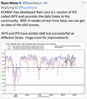
As we move deeper into tornado season 2024, I'm sure everyone wants to make the best forecast possible. So, I'm not certain why so many refer to the GFS. Dr Ryan Maue posted these today and they show just how awful the GFS is -- at times at 1980's levels (really).
In order, the verification stats are better for the ECMWF, UKMET and Canadian than the GFS. I've gotten to the point where I don't even bother to look at the GFS.
I don't have a feel for the AI-ECMWF but I would probably approach it with caution until we have a couple of months under our belts to get a feel for it. In theory, AI in meteorology has a lot of promise but I think we are probably still in the "theory" time period.
Finally, I wish to quote Dr Tom Stewart, then of SUNYA Albany, who did the first-ever studies of human factors in meteorology. Those studies in aviation have revolutionized safety and cockpit order. He found, "meteorologists love more models because they make them feel more confident, but more models do not make them more accurate."
Generic pattern recognition is so valuable
Oh, this is not just you or your story. I believe this to be happening everywhere. "It", whatever "it" is, seems to be trying to replace the person with AI for the past 8-10yrs now?. There seems to be some belief that we can back end "code-out" all of the main parameters, remove the human, so we can ultimately reduce the labor force. That seems to be a strategic view, which implements policy budgets down to curriculum.Absolutely true story: At WeatherData, I had a brand new meteorologist from Michigan. The LFM model, which was quite good, showed a stationary front near the KS-OK border and a strong LLJ overnight. There was a 70% RH surface-500mb blob right over Wichita. I forecast "thunderstorms, some severe" overnight. Took maybe 15 minutes.
Because I was training him, I let him do his own thing (it was his first week) as he was training. He was buried in the models for ~2 hours. His forecast? "Clear." So, I sat him down and explained why I didn't think it was the correct forecast. He was upset and told me that my forecast was probably wrong because I hadn't looked at all of the models, which was true. He was absolutely adamant.
What happened? Tornado warning for Wichita ~4:30am. Then softball-sized hail with what at the time was the 11th most costly hailstorm in U.S. history.
We really can make this way too complicated. If something works, stay with it. If there is a shiny new thing, give it a test drive to see if it is truly a step up. But, never be afraid to stay with what works.