State of the Chase Season: 2016 Edition

well_at_least_May_was_average.png

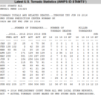
Add the 26 preliminary tornado reports since last Friday and the count for June should become 35. Wow...a whole 35 reports through a little over half the month.

Hey, at least we had an average May...except when you consider the 239 preliminary count is already below the average actual count of 259 and will likely decrease somewhat when reports are confirmed/denied. So May likely wasn't even truly average by count.

Getting serious now...

Most would argue that a small number of quality tornadoes is as good as, or better than, a large number of low quality tornadoes. There have been a handful of quality tornadoes this year, all in May (7th near Wray, 9th in southern OK, 24th in Dodge City, and 25th northeast of Salina). If you caught some, or all, of those, you probably are having a good year. I happened to have missed every single one of those, even though three of them were reachable reasonably to me. I know I'm not alone there. So as far as I'm concerned (and I think this has support from others in the chasing community), this year has been another one worth barfing at. I will also continue to argue until my jaw hurts that at least the events of the 9th and 24th had atypically low predictability, and probably the 25th as well, so those events were not generally the classic type of Plains severe weather/tornado event that can be seen coming a few days out. So in that regard, I think that makes this season even worse than the aggregate counts suggest.
 
Honestly, I'm just waiting for lightning season to really get going here in CO...give me some high based discrete storms and let me shoot away into the wee hours with the milky way as a backdrop. I've had enough of these overcast blobby s@$t days that turn to HP when the lightning starts. I caught a couple TORs this year...good enough, now lets get something photogenic to happen.

$0.02
 
I will also continue to argue until my jaw hurts that at least the events of the 9th and 24th had atypically low predictability, and probably the 25th as well, so those events were not generally the classic type of Plains severe weather/tornado event that can be seen coming a few days out. So in that regard, I think that makes this season even worse than the aggregate counts suggest.

I think the 9th is what stands out the most predictability-wise and just in the overall evolution of the day. The shear profiles on both observed soundings from KOUN and KFWS looked like absolute trash and it seemed like it was just going to be a day with maybe a few pretty, weak supercells off the dryline. Yet it wasn't until maybe 30 minutes before the Wynnewood tornado that it was clear something big was going on. The SPC has gotten a lot of grief this year, and there have admittedly been some very confusing forecasts, but the model performance combined overall forecasting ability given the mesoscale-driven nature of these events has made it a bit of a perfect storm for tough forecasting.
 
Yes the low predictability of the main events this season has really been a killer on my season (personally). Having to drive from Illinois and make a decision the night before is a killer for any setup that you don't really know its going to go big until the morning of. Especially when said setup is 10+ hours away. With that said, I've been able to see a few tornadoes within reasonable distance of home this season, so not a total dud in that respect. And as every summer goes here in the Midwest, there continue to be setups worthy of chasing close to home. As last year illustrated (tornado 2 days before Xmas), one can't call it over until its truly over (Dec 31st). That is one thing I love about living in Illinois, often times we get opportunities for at least severe storms going well into the summer months.
 
Add the 26 preliminary tornado reports since last Friday and the count for June should become 35. Wow...a whole 35 reports through a little over half the month.

Hey, at least we had an average May...except when you consider the 239 preliminary count is already below the average actual count of 259 and will likely decrease somewhat when reports are confirmed/denied. So May likely wasn't even truly average by count.

June might be low, but look at February! While I was chasing snow, I should have been chasing tornadoes!

Seriously though... overall big picture question from a noob forecaster... what caused the early start and end to the season?
 
June might be low, but look at February! While I was chasing snow, I should have been chasing tornadoes!

Seriously though... overall big picture question from a noob forecaster... what caused the early start and end to the season?

For the early end, it's fairly simple -> the death ridge took over too early.

For the quick start, that's a little more tricky. We saw plenty of western trough in December that led to a few significant severe/tornado events during the month. January was more benign, but the majority of the February count was related to the intense upper level trough/low that swept through the South and Eastern Seaboard on Feb 23-24. Beyond that system, a lack of more dynamic troughs through much of the year has kept tornado counts well down once again. The strongly positive PDO can't be helping once again, and it's looking more and more like we've slipped into a long-term positive phase (less favorable for severe), despite the short lived negative phase. We've seen too much eastern troughing and too much central US ridging this year.

June might be low, but look at February! While I was chasing snow, I should have been chasing tornadoes!

Seriously though... overall big picture question from a noob forecaster... what caused the early start and end to the season?

I think more generally this was an issue associated with an unfavorable combination of low-frequency oscillations like ENSO, PDO, MJO etc. I don't know specifically which oscillations are more important, except I'm pretty sure PDO has something to do with it. Also, I attended at least one seminar early in the year that discussed how this previous El Nino was very atypical and did not act like the strong El Nino it was.

These oscillations control synoptic scale weather patterns, and thus highly influence whether or not the large scale troughs that bring most of our severe weather even happen. The oscillations also have an indirect influence on air mass generation and recovery. Doesn't matter if you have a train of strong troughs trekking across the Plains if you don't have the moisture/thermodynamics for instability.
 
Yes the low predictability of the main events this season has really been a killer on my season (personally). Having to drive from Illinois and make a decision the night before is a killer for any setup that you don't really know its going to go big until the morning of. Especially when said setup is 10+ hours away. With that said, I've been able to see a few tornadoes within reasonable distance of home this season, so not a total dud in that respect. And as every summer goes here in the Midwest, there continue to be setups worthy of chasing close to home. As last year illustrated (tornado 2 days before Xmas), one can't call it over until its truly over (Dec 31st). That is one thing I love about living in Illinois, often times we get opportunities for at least severe storms going well into the summer months.

For those very reasons you cited Ethan are why I watch for chase worthy set ups all year long, especially in this region. Too many summertime tornadoes in IL, MI, IN and OH and fall outbreaks can't be wrong.
 
For the early end, it's fairly simple -> the death ridge took over too early.

We've seen too much eastern troughing and too much central US ridging this year.
The ensembles kept progging big ridging in the long-range throughout the spring and like many large pattern changes, the models were too quick with the flip. However, the switch happened suddenly and effectively cut off the commonly accepted chase season. The only thing that has continued has been northeastern U.S. troughing. Maybe that will squeak out an event or two in the Upper Midwest/Great Lakes/Ohio Valley, but chasing in the southern/central Plains is effectively dead and the season never had much life outside of a few localized events.

There are hints at a day or two next week between the Nebraska/Iowa/Illinois area, but again, any event will likely be conditional and localized. Last June/July had multiple threats in this area, but from what I recall, a majority were a huge pain to deal with.

The pattern does favor some continued activity in the northern Plains, but it's rather late in the season and too far north for most chasers to jump at.

Anyone who's into chasing the Canadian Praries should be at least cautiously optimistic about the next few weeks.

On another note, have high risk outlooks become extinct? At least last year we had a couple of events that threatened to possibly go high risk, but this year has seen a dearth of higher-end events.

No high risk days in 2015 (first time since 2000), and the last high risk day was June 3, 2014 (for wind). We are currently in the longest stretch between high risk days since the start of reliable records, that is, 1997. Last high risk in the Plains was in 2012.
 
WED afternoon and evening (6/22) has my eye over Eastern Iowa/Western Illinois. Still several days out, so hard to get into specifics, however NAM/GFS show somewhat of a warm front overlaying across this region with some impressive thermodynamics (3000+ MLCAPE) and strong NW flow (~60 knots). NAM is already going overboard on the EHI/sig tor values along this boundary, too early to get swept up into that.

Setup seems like one that brings a lot of hail/high winds to the region with maybe a couple tornadoes at onset, however one can never be too sure this far out.. We saw a similar one last year on 6/22 that looked as though it was going to be instant MCS and brought numerous tornadoes (some strong) to North Central Illinois/Eastern Iowa.
 
Perhaps out of boredom, I've been coming up with headlines for the "State of the Chase Season: 2016". Maybe I've just been reading too many Onion stories lately, but here's what I've come up with:

"Desperate Chasers Chasing Stratus Clouds"
"Best Chase Setup in Weeks Results in a Wall Cloud"
"SPC Marginal Risk Brings Out Chasers"
"Extreme Chaser Convergence With 10 Chasers in Kansas. [Image: Dots on Map]"
"LEO Claims Roadblocks Work as Chasers Stay Home. Ignores Fact That There is Nothing to Chase."


"Old Man Yells at Cloud"
 
Looking like there might be a few more troughs that ride the roller coaster into the northern Plains coming up with a few opportunities in Minnesota/the Dakotas but I'd say we're just about done outside of the usual July/August shenanigans in North Dakota and the Canadian prairies. Given the pretty decent performance of the last few autumns though, I can't say I'm too worried about not getting another chase in before the end of the year (although now that I've said it, this will likely be the year that breaks the norm).
 
Hope springs eternal, or summers eternal, if one is willing to make large repositions between chase days the next week or so. Still a chance right east of the surface low today in Minnesota, but then trees.

Wednesday could be a good day in upslope territory from the boundary in northwest Kansas northward into the upslope flow. Thursday the warm front could go in Iowa, but if I were really chasing I would use Thursday as a reposition day. Friday could be the far northern Plains day-before-the-day. Saturday looks like a true system ejecting toward North Dakota. LLJ responds to upper jet and moisture returns quite well Saturday. Fri/Sat bring a passport just in case. System lumbers northeast Sun/Mon. Later next week another system may track across the far northern US.
 
Last edited:
Back
Top