Upcoming Chase Season: 2017 Edition

A couple years ago I developed a crude scoring methodology for previous chase seasons going back to 1955 using Storm Data (tornado and hail reports, specifically). I then ran simple linear regressions on the chase season scores against various climate/teleconnection indices. Looking at a 3-4 month lead time, the Arctic Oscillation (AO) had the largest correlation with the subsequent chase season's score. It's a positive correlation, so +AO values during the winter are associated with "better" chase seasons.

So far this winter, the AO has been dominantly positive. In fact, we're just now entering our first sustained negative period since mid autumn! If the GEFS forecasts for the next 2 weeks are reasonably accurate, we should end meteorological winter with a mean AO somewhere around +1.0. All else being equal, this is a good sign for the upcoming season, and particularly the early season.

Of course, there are tons of caveats, including the relatively small sample size. The correlation is not all that strong, anyway (R ~ 0.25 to 0.3, depending on the region of interest). But it's somewhat comforting to know that over the last 60 years, most of the completely dreadful Plains chase seasons occurred following dominantly -AO winters.

With all that said, drought is certainly becoming a concern, especially for the High Plains. The past two years, drought looked like it would be a problem during the winter and early spring, but slow-moving closed lows in April saved the day just in time. So you never know. Unfortunately, the ENSO signal -- weak negative ONI likely transitioning toward weak to moderate positive values during the spring -- is not particularly encouraging, either. Some recent seasons with a similar progression include 2006, 2009, and 2012...
 
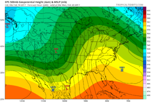
Way too early to be talking about much, but it seems western troughing will take place late next weekend into early next week, indicated by both GEFS and EPS. GFS ensemble is shallower and faster/farther east, but EPS (is EPS on tropical tidbits the true ensemble mean or just one member from the ensemble?) shows several days of return flow with a wide warm sector and strong low pressure system in Lee of the Rockies. I would certainly keep an eye on this time frame for a bit. 9b4f1282fe59401522e776ce06a134e2.png

Seems more like an early May/late April pattern than a February pattern.
 
(is EPS on tropical tidbits the true ensemble mean or just one member from the ensemble?)

You can generally tell whether an ensemble product is the mean or a member by examining the structure of the field. As smoothed and "textbook" as the 500 mb heights in your image look, that's got to be the ensemble mean. Ensemble mean fields are filtered and smoothed compared to what any given ensemble member will look like.
 
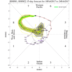
Looks like the MJO pulse that was beginning when I posted recently has really blossomed into an event. Moreover, recent forecasts are consistently showing a significant strengthening as the event enters phase 8, with a rapid die off afterward. Therefore this MJO cycle will probably not directly impact the early season for severe weather, but it is interesting to watch nonetheless.

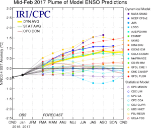
ensplume_small.gif
 
You can generally tell whether an ensemble product is the mean or a member by examining the structure of the field. As smoothed and "textbook" as the 500 mb heights in your image look, that's got to be the ensemble mean. Ensemble mean fields are filtered and smoothed compared to what any given ensemble member will look like.
That's what I thought, especially when comparing to the deterministic EC. I am just impressed by the signal so far ahead for a robust system in the lee of the rockies, with what appears to be a pretty broad warm sector.

In contrast, the GFS/GEFS is much more progressive and really a non-event for the plains. Moisture, this far out, looks to be an issue given strong frontal intrusion currently progged, but I will be watching.
Unsurprisingly, while there will probably be some marginal severe risk in portions of Texas, what will now most likely be a highly amplified system producing heavy rain over the southern plains will of course be a non-event.

Attention turns now to late next week. By then, we should be entering (or in) phases 8-2 of the AAM/GWO with strong troughing pushing into the rockies. W/SW flow aloft will possibly transport weak EML over C/S plains. Given lingering effects of a cutoff low, and time of year, moisture will be limited, however looks like the trend may be to moisten with time. Additionally, if model solutions are to slow (slower translation of wave) then moisture return could actually be better. In any case, looks like next week could be something to watch, but climo says probably not.
 
Agree MJO is a big player but it is too early to get into those weeds. ENSO has some value, including transition between phases: Trans_Nino_Index_(Lee_etal)_version2.0.pdf

Past studies suggested La Nina is active from the Plains through the Southeast; then, El Nino is active early season Deep South and late season Upper Midwest, but less active heart of the Alley. Study above suggests those correlations are weak, esp if not considering the evolution of ENSO from the prior fall/winter into the spring of interest.

Trans Nino Index also looks at the in between phases. El Nino ending early may allow more activity than persistent Nino. La Nina is still slightly more active than normal Midwest to Southeast. However decaying La Nina may be the most active relative to normal in the Plains and Midwest. La Nina is already decaying by SSTs. Atmospheric response was always stronger than SSTs alone would imply. A slow decay in the atmosphere matches North American charts in the paper.


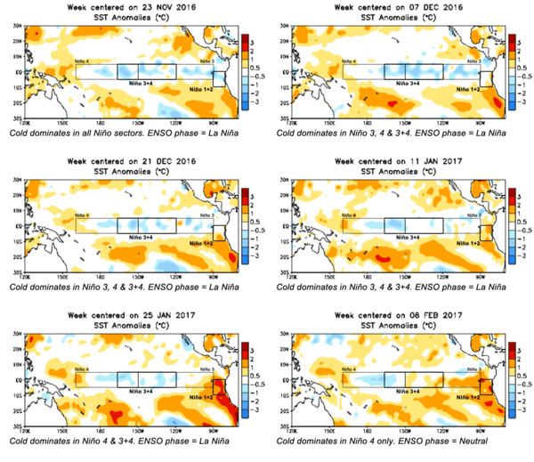
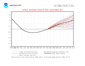
Here's the current state of the ENSO.

c51d7e83308b166001a180f7339df1f4.gif


It's almost looking like an El Niño in the making (mainly in February). The SST's need to be .5° C. above average in the Niño 3+4 for 3 months to be declared an El Niño if I'm not mistaken.
 
It's almost looking like an El Niño in the making (mainly in February). The SST's need to be .5° C. above average in the Niño 3+4 for 3 months to be declared an El Niño if I'm not mistaken.

A lot of the seasonal forecast models are indicating a rebound to a +ENSO state (i.e., El Nino) arriving as early as this summer.
figure4.gif
nino34Seaadj.gif

A developing El Nino is likely not going to have any major impact on the quality of the 2017 spring season, though.

EDIT: I should add that we're punching into the spring predictability barrier right now, too, so take these forecasts with a grain of salt.
 
Last edited:
Here's the current state of the ENSO.

View attachment 15253


It's almost looking like an El Niño in the making (mainly in February). The SST's need to be .5° C. above average in the Niño 3+4 for 3 months to be declared an El Niño if I'm not mistaken.

Just for clarification: El Nino would need 5 consecutive overlapping 3-month periods.

Check out 2008-2009 almost La Nina, the Nov-Mar period missed being classified as La Nina by 0.1, the Feb/Mar/Apr reading came in just over with (-0.4).
 
I'd say it's late enough in the year to start talking about medium-range features of interest in the pre-EVENTS-thread sense.

Looks like the next potential synoptic scale system is slated to cross the Plains early-mid next week (looking like Monday for the plains and Tuesday for the Midwest/Ohio Valley). Tonight's 00Z GFS screams sweeping cold front. However, the 18Z GEFS has quite a bit of variability, not just in the phasing, but also the shape, of this trough. Some members look more favorable for a severe weather event, as they feature a much less positively tilted trough. The Canadian ensemble shows similar variability in the pattern, with many members also indicating a positively tilted trough, but other members maintaining a more neutral tilt and no members indicating a premature occlusion, which seemed to screw up a number of events the past year or two.
 
Considerable uncertainty seems to exist with the large scale pattern not only Monday but afterwards. Not only is this evident in ensembles but also with comparison between deterministic solutions. For example the euro returns to onshore flow without a clearing of the southern plains whereas the GFS blows a cold front into the gulf.

What models seem to be in agreement with so far is a lack of moisture, but I do wonder if this is being under forecast. Nam as usual seems to be the most aggressive, with upper 50s into OK and KS as early as 30 hours prior to 00z of the event.
 
The NAM stayed bullish with moisture on last night's 00Z run, with 60F dewpoints flirting with the Red River and upper 50s in central Oklahoma, but it looks like delayed lee cyclogenesis in the 36-48 hour mark combined with the weakness of it is making for a really crappy fetch prior to the trough coming in. SREF members seem to be progging a much more neutral trough but unsurprisingly, consensus is pretty poor outside of the larger synoptic features.
 
The NAM stayed bullish with moisture on last night's 00Z run, with 60F dewpoints flirting with the Red River and upper 50s in central Oklahoma, but it looks like delayed lee cyclogenesis in the 36-48 hour mark combined with the weakness of it is making for a really crappy fetch prior to the trough coming in. SREF members seem to be progging a much more neutral trough but unsurprisingly, consensus is pretty poor outside of the larger synoptic features.
12z NAM did as the NAM does, popping everyone's favorite soundings across a good chunk of the warm sector along I-35 into KS.

Curious where is a good site for SREF data?
 
Back
Top