Upcoming Chase Season: 2017 Edition

James Gustina

Supporter
Joined
Mar 9, 2010
Messages
671
Location
Dallas, TX
Coming back with one of these threads a bit late this year. Seems like a nice way to pass the time during the first few lean months of the year when there's not much else to talk about other than rampant speculation based on oscillations and climate progs.

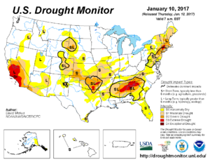
Just to kick things off, the good news is that the worst area of drought or days without meaningful precipitation is mostly confined to the Cimarron an Canadian River basins. The TX Panhandle has been receiving a surprisingly high amount of precipitation. All in all, pretty standard for the time of year.

4c7c1b94b203b74022255131b87ec472.png
 
This may be good news, especially for dryline chasers. Lets see how it holds out. Like to see less dryness over western OK & KS too. I need to refresh and update myself on other factors like El Nino/Southern Oscillation, GOM SSTs, Pacific SSTs and whatever else (been a while so I'm kinda clueless really).
 
c1e092d4166228b3a961ca5d5864d4d7.gif
335303312f17bfb15c0d5e0193bf23e0.gif

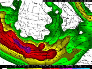
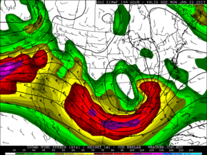
The long range models are in pretty good agreement, with a potential severe weather event for this upcoming weekend for parts of Dixie Alley and along the Gulf. The SPC has highlighted this potential in their day 4-8 outlook. Although there could still be timing and location issues, it will definitely be interesting to keep an eye on this situation throughout this week. It appears right now that shear and instability could be adequate for a decent event. Obviously the location is not ideal for chasing, and it is still a bit too early to get into any of the finer details, at the very least, it is something to watch during the peak of our SDS...
 
Last edited:
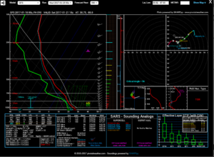
Mobile sounding for Saturday afternoon (1/21) looking loaded gunnish. Good post about the drought @James good to see those areas getting that moisture after a while of being exceptionally dry. Hopefully that bodes well for the upcoming chase season :)
saturday.PNG
 
Turned out to be a tragic weekend for many in the Gulf region. Weather-wise, it seemed like an interesting early-year event. I wonder what it has to suggest, if anything, about the coming chase season.
 
We are off to an ingesting start for sure. I too was wondering what this might mean for the upcoming season, so I did some research. Many of you are likely aware of the Allen, Tippett, Sobel study published in Nature Geoscience in 2015 (Influence of the El Niño/Southern Oscillation on tornado and hail frequency in the United States http://www.nature.com/ngeo/journal/v8/n4/full/ngeo2385.html). While you have to pay for full access (or find a library that subscribes), the abstract gives you some clues: “We show that fewer tornadoes and hail events occur over the central US during El Niño and conversely more occur during La Niña conditions. Moreover, winter ENSO conditions often persist into early spring, and consequently the winter ENSO state can be used to predict changes in tornado and hail frequency during the following spring.”

Cook and Schaefer point out that “researchers do not agree on the seasonal and monthly variations of tornado activity as a function of ENSO phase” in their paper (The Relation of El Nino Southern Oscillation (ENSO) to Winter Tornado Outbreaks, http://www.spc.noaa.gov/publications/cook/ensowntr.pdf) but do conclude “a statistically significant trend for stronger, longer-track tornadoes to occur during LN and neutral winters compared to EN winters is seen.” They go on to note that the most likely zones for tornados vary depending on ENSO phase.

So given our current LN phase and the results of those two studies, one could reasonably hypothesis that we would see stronger longer-track tornados, more tornados in the spring, and the zone of most activity would occur “in a southwest to northeast belt that stretches from the Mississippi Delta to the Central Great Lakes region”.

That may not be a good hypothesis after all. NOAA’s Climate Prediction Center says “a transition to ENSO-neutral is expected to occur by February 2017, with ENSO-neutral then continuing through the first half of 2017.” (http://www.cpc.ncep.noaa.gov/products/analysis_monitoring/enso_disc_jan2017/ensodisc.shtml).

So I took a look at some localized data (http://www.weather.gov/fwd/fwdtornadoes) to see what I could learn form that. In 2017, there have already been 6 tornados in January in the FWD CWA. Going back to 1950, only 11 years prior to 2017 had January tornados. Of those years, 5 where EN, 3 where LN, and 3 where N (a surprise based on the Allen study). The average number of tornados per year in the FWD CWA is 25.5. Of the 11 years with Jan tornados, 5 where bellow average years and 6 are above average years. It is important to note that the lowest bellow average year was only bellow by 5 tornados. Of the above average years, only one year has 1 standard deviation above average (1996 which had 51). 3 years had 10, 12, and 13 more tornados each and the other 2 where barely above average. I should note that as one goes back towards 1950 in the pre cell phone days, the number of tornados is likely underreported.

Bottom line to me – this is fun to talk about, and I remain optimistic about the coming season, but I don’t think we can draw too many conclusions right now. For one, we may be ENSO neutral by spring. For another, the effects of ENSO on tornado counts in any given area are still a subject of great debate. We wouldn’t use the GFS 384 hours out to pick a target area, so we probably should not get too excited or depressed over the chase season this early either.
 
It's all in the snowpack I think. ;)
I think we need,by law, all farmers to turn on their center-pivot irrigation systems with snow making nozzles when the temp is low enough. Blanket Kansas!
 
I think there are 2 overall 'things' to consider when looking at the upcoming chase season: 1) The overall season, and 2) When you might chase.

For 1), we can sometimes get a reasonable impression of the overall chances of it being rather active or less active, by looking at the various analogues, large-scale climate indicators (e.g. PDO, ENSO, etc), as well as models. However, unless you have the relative luxury of being able to chase whenever you can (or a close approximation to this), you'll more likely be interested in a specific window, especially if, like me, you have to plan months in advance. In that case, the overall season's activity is rather overshadowed by unresolvable sub-seasonal effects. E.g. you could be in the middle of the most active season for years, but have a 2 week period of upper ridging, simply due to the state of the atmosphere at that point in time. If you time your trip with this, because you have to plan far ahead, then the season has not been a good one for you!
 
It's probably not too early to begin considering how low-frequency seasonal and even sub-seasonal patterns may be setting up to provide some degree of predictability for how the 2017 chase season will go. One particular feature I tend to pay attention to is the MJO, which can be monitored on the CPC website here (http://www.cpc.ncep.noaa.gov/products/precip/CWlink/MJO/mjo.shtml). An MWR paper from a few years ago pointed to a link between MJO phase 2 and increased violent tornado outbreaks during March-May (and a reduction in tornado outbreaks during phase 8). Great! So how do we know when the MJO will be in phase 2? MJO prediction is not easy, nor particularly skillful, so that's still up for debate. You kind of still have to monitor current MJO conditions and perhaps operate under the assumption that if an MJO pulse begins in phase 1, then phase 2 is not far away, or that if a current MJO pulse is already on phase 3 or later, then phase 2 is probably a long way away. Since the MJO takes 30-60 days to complete, there's basically only going to be one cycle during the spring season.

The final requirement described in the paper above is that you need to have a supportive large-scale setup already present when phase 2 of the MJO occurs. This pattern (Fig. 7 in the paper) features anomalous ridging at 300-mb across the western north Pacific and anomalous troughing across the western US (with some mildly anomalous ridging across the southeast US).

The current MJO status: RMM > 1.0, which means there is actually some distinguishable MJO signal above the noise level, and it appears to be crossing over from phase 4 into phase 5. G(E)FS forecasts call for the signal to strengthen and progress across phases 6 and 7 and into phase 8 by the mid-late part of February. Should it continue (once an oscillation is started I don't think there's any guarantee it will continue to progress across the rest of the phases) at a constant pace, it may be in phase 2 by early March, which may suggest an increased potential for early season tornado events. However, that is pure speculation at this time and is based on some really long range forecasts. It's best to continue to monitor the MJO index (RMM) throughout the rest of February and into March to see what help (or hindrance) the MJO may offer for 2017's traditional season.
Good stuff.. saw a presentation at SLS regarding MJO phases and tornado activity. Gensini I think does one using the global wind oscillation or whatever..

Extended range model forecasts don't show any particularly harsh gulf clearings occurring anytime soon, so I could buy an early-mid March setup happening *if* the general pattern persisted.
 
Extended range model forecasts don't show any particularly harsh gulf clearings occurring anytime soon, so I could buy an early-mid March setup happening *if* the general pattern persisted.

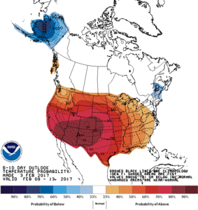
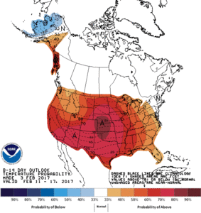
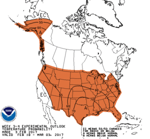
That's a good point about Gulf clearing. I recall seeing an extended range forecast suggesting the second half of February would be very much above average in terms of temperature CONUSwide, which would suggest a minimum, if not an absence, of fronts making it to the Gulf. CPC's outlooks for the next several weeks concur...

6-10 day temperature outlook:
610temp.new.gif

8-14 day temperature outlook:
814temp.new.gif

3-4 week temperature outlook
WK34temp.gif

70% probability of above average temps at 3-4 weeks with this kind of lead time makes me lol. These are very strong indications of a warm end to February. Now, they're also paired with solid probabilities of below average precipitation, and there is an ongoing drought across parts of the southern plains, especially Oklahoma. So moisture could certainly ruin any early season setups. We will just have to wait and see.
 
Agree MJO is a big player but it is too early to get into those weeds. ENSO has some value, including transition between phases: Trans_Nino_Index_(Lee_etal)_version2.0.pdf

Past studies suggested La Nina is active from the Plains through the Southeast; then, El Nino is active early season Deep South and late season Upper Midwest, but less active heart of the Alley. Study above suggests those correlations are weak, esp if not considering the evolution of ENSO from the prior fall/winter into the spring of interest.

Trans Nino Index also looks at the in between phases. El Nino ending early may allow more activity than persistent Nino. La Nina is still slightly more active than normal Midwest to Southeast. However decaying La Nina may be the most active relative to normal in the Plains and Midwest. La Nina is already decaying by SSTs. Atmospheric response was always stronger than SSTs alone would imply. A slow decay in the atmosphere matches North American charts in the paper.
 
Last edited:
Back
Top