La Nina Forecast 2018

Warren Faidley

Supporter
Joined
May 7, 2006
Messages
2,421
Location
Mos Isley Space Port
I thought about titling this thread "The State of the 2018 Chase Season" as a joke, but after last year, it's not funny.

So I received the ENSO outlook today and it forecasts the current weak / moderate La Nina will continue through the winter with a transition into ENSO neutral conditions during the spring.

I know there are many theories about the effect of La Nina / El Nino on chase seasons but the general consensus leans towards a slightly less active May / June.

W.
 
Overall activity notwithstanding, the biggest thing La Nina does it trigger a drought across parts of the western and central US, pushing the dryline further east come May. This has consequences in two areas: 1) It can lead to more activity E of the Mississippi River as we get more instances of a dryline pushing east without mixing out. This can lead to some BIG outbreaks across Dixie and the OV such as Super Tuesday and the 2011 Super Outbreak. (The 1974 Super Outbreak was a post-Nina winter as well). 2) Across the plains, while it isn't always a death knell for areas west of I-35 (Such as 2008), a Nina year usually isn't a good thing if you're hoping to be able to chase in friendly terrain. The Upslope Plains and the Panhandles usually don't get much as they're often mired in drought conditions. This often forces the dryline to set up close to I-35, which obviously isn't particularly what you want as a chaser as you're now contending with major metro areas and the transition zone between the Great Plains to the west and the more forested areas to the east.

Does that mean May and June are going to be duds? Not necessarily. May 2011 had that big sequence late month, but as I noted above, it stayed generally along and E of I-35 and didn't offer much in more of the traditional chasing terrain.
 
Across the plains, while it isn't always a death knell for areas west of I-35 (Such as 2008), a Nina year usually isn't a good thing if you're hoping to be able to chase in friendly terrain. The Upslope Plains and the Panhandles usually don't get much as they're often mired in drought conditions. This often forces the dryline to set up close to I-35, which obviously isn't particularly what you want as a chaser as you're now contending with major metro areas and the transition zone between the Great Plains to the west and the more forested areas to the east.

I hope I didn’t misunderstand your comments regarding 2008, but my memory of 2008 was of chaseable storms daily even west of I-35. The upslope season along the front range was prolific with chases on offer darned near every afternoon from late May through early June. May 22, 2008, was a big day, with the Windsor, CO half mile wide tornado. That day’s event took place west of I 35 http://www.spc.noaa.gov/climo/reports/080522_rpts.html as evidenced by the map from SPC.

In any event I hope we get a decent year in 2018 whatever takes place.

That's actually what I meant. 2008 was an odd year in which the Upslope and High Plains was very prolific and active despite coming off a Nina. That's something you don't often see, although it is possible.
 
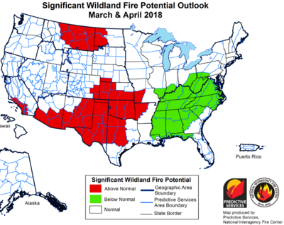
I might be wrong, but I think the big news this year will be wildfires, especially in the TX Panhandle and southern KS. If you recall, we've had some decent rainfall in the past couple of years which in turn has resulted in a LOT of vegetation growth (fuel for the fire). Now we are in a drought again. The TX Panhandle and southern KS has not had any measurable precip in at least 85-90 days.

I recall in 2006 (wildfire year) that I would wake up in Amarillo and see dewpoints in the upper 50's to low 60's. By noon the dewpoint would drop to the upper 30's, and the dryline would be way out in western or central OK. I fear this year will be a repeat if things don't change very drastically in the next couple of months.
 
I think Jason is right. I don't see any climate shift to suggest an overall pattern change that would move activity west during the traditional periods of May and June. My (non-climatologist) opinion is that average chasing territory is slowly moving east every year. Of course there will be isolated, even major events west of OKC, but they are fewer and fewer. The fire danger in the southern Plains will likely be off the charts this year.
 
I am no fan of La Nina. It has already royally screwed up the ski season in the southern Rockies, and now it could do the same to the chase season in the southern plains as others have pointed out. All that drought over the southern plains would certainly seem to me to push the best potential for storms east, and maybe north as well. And the wildfire danger won't just be high in the southern plains, it will also be high in the southern Rockies (where I live) if this dry pattern continues much longer. Regarding the chase season, one can hope that there will be some decent setups at least occasionally despite the overall pattern, but when a good setup comes along west of I-35, better jump on it because there may not be too many others. Time will tell.
 
I remember hearing Dr. Greg Forbes speak at ChaserCon 2014 about the correlation between large scale patterns such as El Niño / La Niña and tornados / tornado outbreaks. Although I can’t recall the details, I remember my main takeaway at the time was that any possible correlation was inconclusive at best. This may not have been as granular as addressing the impact in our favored regional chasing areas, i.e. west of I-35. Below is a link to the presentation if anyone is interested. Unfortunately, it is poor quality; you can hear Dr. Forbes fine, but won’t be able to see his slides up on the screen.


Sent from my iPad using Tapatalk
 
I think Jason is right. I don't see any climate shift to suggest an overall pattern change that would move activity west during the traditional periods of May and June. My (non-climatologist) opinion is that average chasing territory is slowly moving east every year. Of course there will be isolated, even major events west of OKC, but they are fewer and fewer. The fire danger in the southern Plains will likely be off the charts this year.

I wouldn't go so far as to say we're seeing a permanent trend towards I-35 as the new "average" chasing terrain. I'd argue that, if you consider strong/violent tornadoes, that always HAS been the "average" area for our biggest events.

Consider this: There have been 59 tornadoes rated F/EF-5 in the modern era of rating storms. Of those 59 EF-5 tornadoes, only 16 have spent a portion of their life W of the I-35 corridor.

If you narrow it down further to EF-5 tornadoes that spent their entire life cycle W of I-35, this drops the number even more, from 16 to 10. There are 8 EF-5 tornadoes alone that are within 20 miles or so of I-35 at some point along their track, and only 7 are what I would consider to be a significant distance W of I-35.

Even if you go down to EF-4 tornadoes in say.. the state of Oklahoma where I-35 splits the state almost exactly in half, the highest density of EF-4 tornadoes occur along the I-35 corridor, give or take about 30 miles in either direction. There's only a handful of storms in the western part of the state a good distance away from I-35, and they are very spread out. The vast majority of tornadoes spend at least part of their track no more than 30 or so miles west of I-35 or they cross it at some point.

While the most photogenic storms may be a good distance west of I-35, in terms of raw numbers, the I-35 corridor has always been the tornado hotbed of the great plains.
 
Haven't read much of the other responses here, so apologies if I am duplicating this, but my understanding of La Nina on the following spring tornado season is an increase in tornadoes in the lower Mississippi River valley area (E OK, AR, MS, E TX, LA).
 
During my time chasing from 2006-present, there's never been a La Nina winter/spring with lush vegetation and frequent quality setups over the southern High Plains (W TX/Panhandles/SW KS). On the other hand, every single El Nino winter/spring has featured lush vegetation, evapotranspiration, and at least several good setups in that region (2007, 2010, 2015, 2016).

It's true that ENSO correlations with tornado activity over the CONUS as a whole, and for many sub-regions of the central U.S., are ill defined. However, if you really hone in on the southwesternmost corner of the Plains, the evidence appears strong in favor of Nino and against Nina. Of course, some La Nina years are still active in areas immediately W of I-35 like W OK and C KS, and it seems to matter less (in terms of drought) as you get N of I-70. I just wouldn't expect to be chasing lots of setups with manageable LCLs in the Panhandles this year, if experience is any guide.

My only other thought is that weakly- to moderately-cool ENSO winters where we're trending toward neutral or warm by late spring do not have a great track record, so hopefully, the "spring barrier" is at play in the latest forecasts.
 
I believe the overall drought pattern is likely playing a bigger role in the reduction of severe weather west of I-35. I'm not sure if there is enough data to connect the ENSO patterns to larger scale climate changes.
 
Thankfully the drought isn't 2014-levels of bad yet but I'll echo the sentiment of neutral/La Niña winters generally resulting in crap seasons, specifically through late April. It's hard to foresee consistent setups with serviceable moisture west of the Cross Timbers should there be no multi-day precip event between now and the end of February.
 
I believe the overall drought pattern is likely playing a bigger role in the reduction of severe weather west of I-35. I'm not sure if there is enough data to connect the ENSO patterns to larger scale climate changes.
It's possible this trend is occurring on long timescales, but that region has seen ample rains in March and April the past three years, leading to good ET during the heart of chase season.

The "W of I-35" part of the southern Plains was ripe for action in 2015 (Elmer, Canadian, Dora, Simla), and it was the epicenter of virtually all the good chase events in 2016. Last year, moisture and LCLs still weren't much of an issue, even though we had few quality events for other reasons.

The painful stretch from 2011-2014 rightfully concerned folks about whether classic chase country of 70s and 80s lore was undergoing some sort of rapid desertification, but subsequent years helped to quell those concerns, at least for me.
 
Back
Top