• After witnessing the continued decrease of involvement in the SpotterNetwork staff in serving SN members with troubleshooting issues recently, I have unilaterally decided to terminate the relationship between SpotterNetwork's support and Stormtrack. I have witnessed multiple users unable to receive support weeks after initiating help threads on the forum. I find this lack of response from SpotterNetwork officials disappointing and a failure to hold up their end of the agreement that was made years ago, before I took over management of this site. In my opinion, having Stormtrack users sit and wait for so long to receive help on SpotterNetwork issues on the Stormtrack forums reflects poorly not only on SpotterNetwork, but on Stormtrack and (by association) me as well. Since the issue has not been satisfactorily addressed, I no longer wish for the Stormtrack forum to be associated with SpotterNetwork.

    I apologize to those who continue to have issues with the service and continue to see their issues left unaddressed. Please understand that the connection between ST and SN was put in place long before I had any say over it. But now that I am the "captain of this ship," it is within my right (nay, duty) to make adjustments as I see necessary. Ending this relationship is such an adjustment.

    For those who continue to need help, I recommend navigating a web browswer to SpotterNetwork's About page, and seeking the individuals listed on that page for all further inquiries about SpotterNetwork.

    From this moment forward, the SpotterNetwork sub-forum has been hidden/deleted and there will be no assurance that any SpotterNetwork issues brought up in any of Stormtrack's other sub-forums will be addressed. Do not rely on Stormtrack for help with SpotterNetwork issues.

    Sincerely, Jeff D.

State of the Chase Season 2025

This week could be better for chasers than one might infer from SPC outlooks. Both can be right, given SPC is for public awareness. Chaser interests can be met on a mesoscale / local level. It's a beautiful thing.
Outflow boundaries are going to have a bigger than expected impact on the SVR weather potential for at least the next week +. Models have backed off displacing RH out west, so it's likely there will be several classic DL events in the offering. If the forecast keeps supporting western TX and E. NM initiation for multiple days, I might have to try and deploy sooner than later. No RH crashing fronts are forecast to ruin the show as often happens this time of year.

Days with modest upper-level flow, I'd absolutely target the outflow intersection with DL. This is not the setup for a big DL push. Just that locally enhanced SRH right at the intersection. Tuesday could work. Wednesday has less forcing, but we'll see.

Then Thursday and Friday might have rising heights one of those days, but modest southwest flow aloft returns, along with evening LLJ response. Cap could be a battle, but one of those days could be a hidden gem. SPC covers the weekend into Monday over in the MIdwest in their Day 4-8 discussion.

Little part of me wishes I had set the table better for this week. Unfortunately it's too late to get the cards to fall on the home front. Maybe next week!
 
Yeah unfortunately the coming weekend is out for me, poor planning on my part, I was too willing to accept optional personal commitments, at the time thinking “it’s not even May yet”…

That said, with this current week a no-go because of work, and then my son’s award ceremony on Tuesday 4/29, would this weekend alone be good enough to justify the time, trouble and cost, even if I could have squeezed it in? Most likely not…

I’m going to forget about the upcoming pattern and start looking ahead to 4/30… I could do a one-week trip beginning then, but have to get back for personal stuff on 5/7… Then I have time for another 10-day trip beginning less than a week later, the day after Mother’s Day; then it’s back home for my son’s college graduation, and after that the two of us head out for our “core” 16-day trip on 5/23. It’s a “Swiss cheese calendar” to be sure, but I’m fortunate to have anything at all beyond the two weeks I have been limited to for most of my 25 year chasing career…

These are not all “chase vacations”; they are just windows of time that I can work remotely and chase when applicable. The bar will be high to bother making the trips, especially that shortest one the first week of May, and I’ll have to be selective even when I’m out there to conserve PTO. But I want to bias toward going out there “just in case,” rather than looking for the perfect pattern.
 
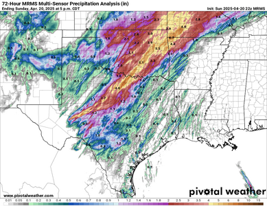
Just for posterity, here's the end result of this past weekend's (4/18-4/20) rain dump. Predictably, the cold front surged southeast Friday and nixed that day's marginal chase op, then focused the most prolific rainfall in the jungles SE of I-44. Still, this was another pretty good dump for much of OK outside the panhandle, as well as the southeastern 1/3 or so of KS.

mrms_qpe_072h_p.us_sc.png

Combined with the early April rain event, most of OK and N TX are now in the general realm of normal precip for the past 30 days -- so I'd expect green-up, evapotranspiration, and afternoon latent heat flux to be respectable there over the next several weeks. There's still a lot of work to do for most of NE, KS, E CO, and the Panhandles, though.

Back to the actual weather: the next 7-10 days look uncannily like late May or early June in some respects. Multiple marginal/mesoscale days are apparent in W TX this week with 0-6 km bulk shear struggling to reach 35-40 kt, except in any pockets of stronger low-level southeasterlies. After that, I agree that some day(s) from April 26-29 should offer the real payoff -- if there's going to be any -- for this prolonged period of moisture return and mean western troughing.

One thought about the longer range: I don't subscribe to the broad brush idea that an active early season means a doomed peak/late season. However, anecdotally, the years I can recall having long stretches in April with a sloshing dryline and anemic southwest flow like we're about to see have tended to go quiet later on (2009, 2012). Combined with seasonal analogs and S2S model output looking sketchy for May, I'd personally lean aggressive in choosing whether (or how much) to chase this upcoming period. But, on the optimistic side, we could very well end April with short-term drought largely mitigated on the southern Plains... and that would be an undeniable advantage come May and June over a year like 2012.
 
Pulling the trigger, leaving tomorrow. Wed. and Thu. are two stealth days in the good chase territory from SW Kansas to the TX Panhandle. Friday is probably down. Then, starting maybe on Saturday and for sure on Sunday and Monday, the stronger flow should start impinging on the Plains as the western trough moves out. There is a fair amount of spread regarding the details, but somewhere should have tornado potential.
 
A trend I just noticed on he latest Op and Ens runs- On Sunday, the upper trough is too far west for enough forcing for daylight storms, then it ejects with poor timing, resulting in the storms shifting way east, and worse, it comes out with a positive tilt. Probably fretting too much but still...
 
A trend I just noticed on he latest Op and Ens runs- On Sunday, the upper trough is too far west for enough forcing for daylight storms, then it ejects with poor timing, resulting in the storms shifting way east, and worse, it comes out with a positive tilt. Probably fretting too much but still...

I have similar concerns. The margin for error with details like timing is always smaller this early in the season. A few days ago, this upcoming major W US trough appeared on most guidance to get "stuck" roughly around the Great Basin and sit there for several days before shearing out over the Rockies. Guidance then shifted much more optimistic over the last 48 hours, but even a partial trend back in the "stuck" direction could result in a scenario like you described. The ongoing sporadic missed balloon launches at NWSFOs only serve to make apparent trends in medium range guidance more difficult to trust or interpret.

Plus, we are on an absolutely staggering run of mis-timed events for the S Plains going back all the way to March of last year. Yet again, we saw multiple damaging tornadic supercells swarm N TX and OK as soon as it got dark this past Saturday night. I've lost count of how many events have followed that exact script the past 13 months, but it's more than half a dozen. At this point, I'm really just hoping we can at least squeeze one solid day out of the whole period, even if it turns out to be a weakly forced setup on Thursday or Saturday.
 
Back
Top