State of the chase season 2020

Status
Not open for further replies.
The ensemble GFS is looking primed for the back half of May. I generally don't put too much weight into the ensembles, but almost every single one of the members are in agreement of an active couple weeks. The CFS is also showing good promise for the second half of May. It seems weird to me that the deterministic GFS isn't showing this optimism so I won't get too excited until we start seeing it there but if the ensembles are correct, we finally have something to look forward to the week before and after Memorial Day.
 
Just took a look at the 12Z GFS (from this morning). Not exactly the most optimistic thing I have seen. Has a higher-latitude trough punching into the Rockies next weekend, but then stalling before really getting close enough to the Plains to provide for adequate shear outside of E CO/NE NM. But the moisture doesn't get anywhere close to there - the seasonal DL looks to be setting up a little bit more east of there, only occasionally ebbing westward towards the CO/KS border longitude. I even saw a cold front wiping out Plains moisture in the 300+-hour range!

Not what I'm hoping to see, even in fantasyland.

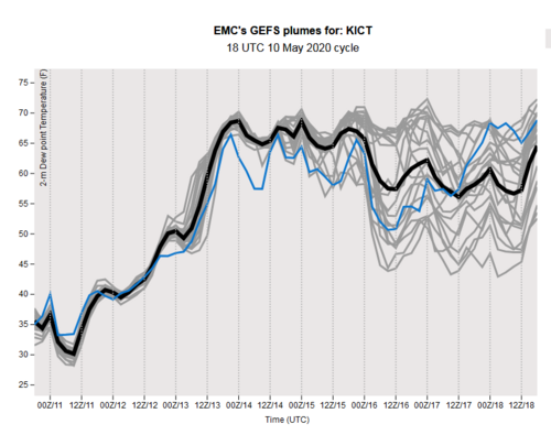
Checking more on the DL/moisture status...took a look at sfc Tds from the GEFS at Wichita...should give a sense of whether moisture is progged to at least begin sticking around, and...Screenshot_2020-05-10 EMC GEFS plumes.png
...while not terrible, there is more uncertainty than I would care to see.

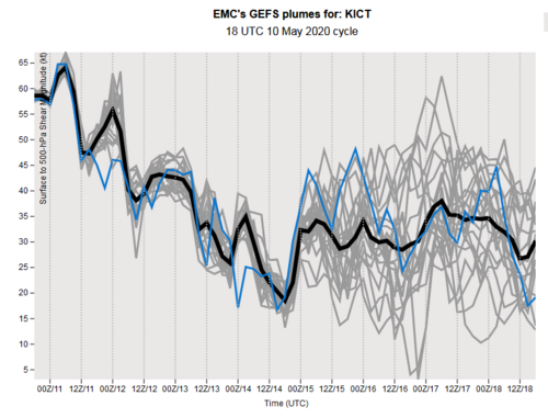
Shear doesn't look stupendous, either, although it, too, doesn't look terrible...
Screenshot_2020-05-10 EMC GEFS plumes(1).png
Not great to see such little probability mass north of ~40 kts.

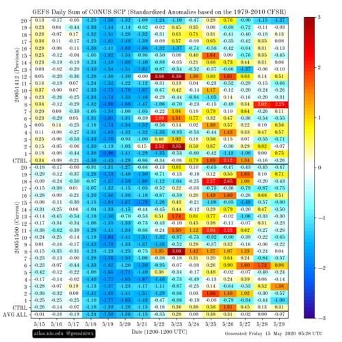
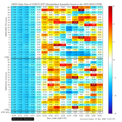
The SCP outlooks from Victor Gensini's page still shows a period where increased activity is at least possible, but as time has passed, the uncertainty level has not decreased. At. All.
gefs_scp_stda_chiclet.png
It is wonderful to see a positive-anomaly signal in the mean, but the variability among that outside of the 5/15-5/17 window is discouraging. The good news is, in the latest ERTAF (fresh off the presses), the team went with "AA" for week 2, and with medium-high confidence. So I'm hopeful I'm just looking at this through shit-colored glasses! I could go for a pattern featuring slam-dunk events.

I'm more than ready to start chasing this year.
 
Thanks Jeff for the details. Spent a couple of hours this morning pouring over the models trying to extract some long shot reasoning for heading out. I can live with cap chances or lower RH, but the overall lack of any substantial upper level flow is a deal breaker. Wednesday is looking more like an HP fest. The NCEP Ensembles have come on board with weak flow though at least May 22nd. Hopefully we can have at least a decent NW flow period towards the end of the month or some eastern Colorado set-ups.
 
Uncertainly in the extended range (this weekend into early next week) is associated with a weak cut-off low that might settle into Texas. It is hard to see on ensembles. One can check individual GFS runs for its existence, but don't take placement seriously. Euro has it too esp at 700 mb. Also shows as weakness at 500 mb. Regardless, effects are troublesome if it's there.

If the low settles into Texas, several things happen. Return flow is hosed. LLJ stays meager. Explains why some models have all this CAPE far North and meh Central Plains. Dews don't return like one would expect in late May. West Trough stalls (blocked) out in the Rockies. Said low is about mesoscale, and most pronounced at the mid-levels. While the hemispheric pattern shapes up great for severe, these things can hamper it.

Ensembles hint at another window of opportunity after the cut-off low ejects or just gets absorbed in the flow - late next week (May 21+). However by then the Rockies trough is shown filling as it comes out. Unbelievable! Well, actually it is believable the last several years.

I'm happy to see ERTAF go AA week 2. Note the climo. It's a weak number the way the days fall. Most weeks in May are 65+ but week 2 only has to beat 53. They don't go into their previous forecast disco. However they correctly had late this week perking up.

Bottom line: Opportunity will present itself to patient chasers who know how to forecast mesoscale. However I don't expect 7-10 lit up days like last year. Don't expect big single day outbreaks either. A couple 2-3 day periods could be better chasing with fewer crowds.
 
GFS and CFS have been trending the third week of May to be more towards the Northern Great Plains, it seems. That is where they have had the best 500mb flow. Before GFS came into range CFS had been showing the trend in 500mb flow. GFS Ensemble seems to think that too. Looks like a 4 day period from Mon the 18th - Thurs the 21st, dews ranging from 60 - 70 across the region. It looks like peak of Tornado Season may be focused on the northern plains region, which is fine with me, that's where I am from.
 
Well that possible multi-day set-up fizzled out, I was still on the fence as recently as yesterday but decided against a trip after looking at the latest runs. While Wednesday has the potential for tornadoes it looks to be the only chase-worthy day and the potential just doesn’t justify a 2000+ mile trip. I’ve done a few of those but unless the potential is much higher than Wednesday’s I need at least an extra day or two of chasing to make it worthwhile. Also, the target area appears to be limited to mostly western Oklahoma so I imagine the crowds could be ridiculous. So 2000+ miles for a marginal single day chase among the hordes? No thanks. It’s still early/mid-May and unless the season is a total bust I’m confident better opportunities will come around.
 
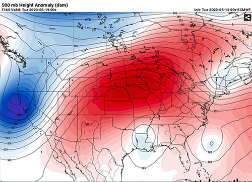
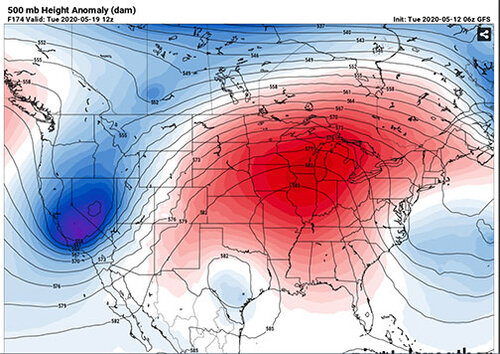
Both the GFS and the ECMWF are in good agreement with blocking the tantalizing upper level flow, keeping it at bay through at least the beginning of next week. Not only does this squash the Central Plains, but regions further North. Other indicators like the 8-14 day CPC precipitation outlook and the NCEP Ensembles are in full(+) agreement. In fact, the NCEP Models show serious ridging through the 27th. (%$%#@!). I think by late in the weekend, we will have a generally good idea of what the future holds for May. I am by no means saying the season is over. The ridging could break down with the next model run(s) and we still have the NW flow period to watch in late May into June.

ecmwf.jpggfs.jpg
 
Both the GFS and the ECMWF are in good agreement with blocking the tantalizing upper level flow, keeping it at bay through at least the beginning of next week. Not only does this squash the Central Plains, but regions further North. Other indicators like the 8-14 day CPC precipitation outlook and the NCEP Ensembles are in full(+) agreement. In fact, the NCEP Models show serious ridging through the 27th. (%$%#@!). I think by late in the weekend, we will have a generally good idea of what the future holds for May. I am by no means saying the season is over. The ridging could break down with the next model run(s) and we still have the NW flow period to watch in late May into June.

I don't use the ugly phrase "death ridge" often, but man...(Joker reference, and substitute "death ridge" for "squealer": YT (watch 4 seconds only)). It's not a good sign when troughs are maturing at 120 W lon. rather than 110-105 W lon and then filling or stalling.
 
Looks like the next **shot** will be Wednesday or Thursday of next week as the flow moves ever so slowly east. Moisture is forecast to remain in place, so that's one less thing to worry about. Not paying much attention to anything beyond early next week.
 
Jesus, just when you think it can't get any worse, now there's a massive cut off low that sits over the eastern US next week and fudges everything up for days.....
 
Barring a **miraculous** flip-flop in the models, it would appear the 2020 chase season will go down as one of the worse in storm chasing history. Cannot find any hope in the models, with nothing trending towards a more favorable solution. There seemed to be some hope for a northern season in mid-to-late May, but the ECMWF is really keeping the RH to some of the lowest levels I have seen in years. This on top of anemic upper level flow of biblical-low proportions. Yes, there may be a long shot at a sneak attack next Wednesday, Thursday or Saturday, but nothing obvious to justify a major chase operation unless you live in the region. The only hope is a shift in the ridge that could make for a 3-4 day chase late next week.
 
Wow. I really had higher hopes for 2020 with the talk of an incoming La Nina and the PDO going negative for the first time in a long time. At the end of March my main concern was missing out on stuff due to the COVID pandemic. Now it seems there won't be much to miss. Can barely get any thunder with the rain showers in this neck of the woods.
 
Agree. Been keeping tabs on Victor Gensini's GEFS SCP chiclet chart and it has totally gone to shit for a period that was previously bilked as likely to be active. Check out this shit:
gefs_scp_stda_chiclet.png

About 10 days ago the same time period (5/15-5/21) was full of positive SCP coverage anomalies.

The pattern has just gone to complete shit.
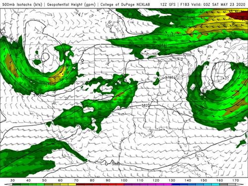
GFSUS_500_spd_183.png

I mean, what the hell is this? It's not so bad as a big ol' summertime death ridge, but the pattern is so fragmented...there are small troughs and local speed maxima all over the place. None of them persist long, and all of the troughs that cross the Pacific coast stall and dissipate before getting much east of 120-115 W.

There are areas with supercell shear and sufficient CAPE, but it is largely unpredictable beyond a day or so and there is nothing larger-scale to look forward to. This is not a typical May pattern, and it is excessively frustrating to be dealing with at a time like this. I have been depending on my faith in a storm chasing season to carry me along over the past few months and it just isn't materializing at all. Such garbage.

Shit, we still had freezes and daytime highs in the 50s to near 60 in the Denver area earlier this week. So...it's not warm enough to decenly be spring yet, but at the same time the upper-air pattern resembles more of a summer pattern than a springtime pattern. Ugh!
 
I am amazed how bad the mid level flow looks. Then you look at soundings and realize that even with decent instability there are still capping issues, lack of good moisture, and high LCLs even on days with better parameters. We just can't get one day with everything coming together at the same time. Might have to take a shot at late next week because what the f*ck else is there to go after? Even the CFS doesn't show any sort of trend with prolonged periods of good parameters extending all the way to mid June. WTF?!
 
Status
Not open for further replies.
Back
Top