State of the chase season 2020

Status
Not open for further replies.
Thanks! Not sure how I've missed that before now.

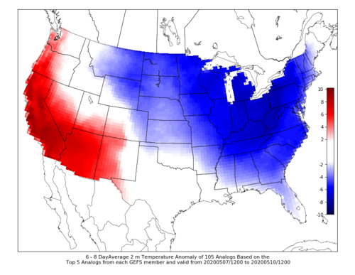
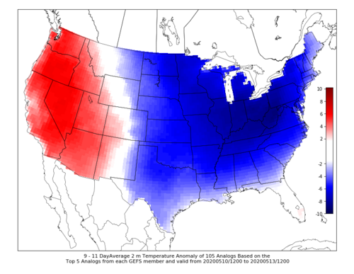
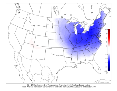
I'm attaching a snapshot from 4/30 for future reference. Soil moisture is tending drier than normal in the central High Plains, and fairly close to normal further south into the Panhandles. The anomaly change from 3/31 to 4/30 shows that the NW flow pattern over the past month has not been, and will continue not to be, helpful.

That is bad, but look at the soil moisture percentiles across the SW US...especially in S AZ/S NM, they're definitely on the high side of the distribution, so it's not all bad just yet. I don't have a problem going into May with things looking like they do. A flash drought would be the thing to kill off the season at this point.
 
Not that it hasn't already been hit on enough in this thread recently, but I am impressed (not in a good way) with the pattern that is forecast for these next couple weeks. CIPS extended analogs have a relatively high frequency of < 32F for surface temps down to the Ohio River Valley for the Day 6-8 and 9-11 outlooks. I'm fine with a lack of robust severe setups at the moment, but some thunder would be nice. Given the surface temp anomaly maps from CIPS (below), that's going to be hard to come by for most of us with that type of pattern.
 

Attachments

  • Day_6-8.png
    Day_6-8.png
    160.6 KB · Views: 0
  • Day_9-11.png
    Day_9-11.png
    158.3 KB · Views: 0
  • Day_12-14.png
    Day_12-14.png
    145.8 KB · Views: 0
It's not quite the same evolution as last year due to the *very* northward displacement of this year's NPJ, but I'm getting a bit tingly if the MJO dynamical fields can hold on and result in a nice increase in convection over the maritime continent. If this propagates toward the dateline, we should be very much in business for the back half of May.

Dr. Gensini,

Great points, as always. Much like yourself and others, I am heartened by what I see depicted for the latter 1/3 of May. The most recent observational and forecast data has been trending towards a more coherent progression of MJO dynamical fields. I am particularly interested in how things evolve over the next week or two. The noise being depicted thanks to the developing IO standing wave near 60E. There are also signals for decreasing subsidence and broad -VP east of 120W. The EPS remains more steadfast in non-propagation, though I have noticed it tends to resist propagation towards the MC regions.

Still, the most recent data from the CFS and GEFS (attached) from both NCICS and Dr. Ventrice's available data are increasingly impressive to me and suggestive of the necessary propagation and amplitude. BOMM bias adjusted RMM plots, while accounting for the typical RMM restrictions, show a more amplified progression into 8-1-2 than any other dynamical forecast at this time. Such a progression (while far from a guarantee) would suggest the potential for a very favorable wave evolution across the NPAC and CONUS from the final 7 days of May perhaps continuing into early June.

There is still quite a bit of noise and uncertainty to sift through in the next week or so before any confidence can be added (in my opinion), including exactly how tropical forcing (in a very general and basic sense) evolves, the evolution of dynamic final warming of the stratospheric polar vortex, etc. Like most, I'll be watching closely and planning to head out into the "field" starting May 15th. As it stands today, I am encouraged by what I see in terms of potential activity. Fingers crossed.

Cheers,

John
 

Attachments

  • BOMM_phase_33m_small.gif
    BOMM_phase_33m_small.gif
    53.6 KB · Views: 0
  • chi200.orig.eqtr-3.png
    chi200.orig.eqtr-3.png
    123.3 KB · Views: 0
  • twc_globe_mjo_vp200.png
    twc_globe_mjo_vp200.png
    680.4 KB · Views: 0
Well, obviously, disaster weather patterns are forecasted. Polar vortex becomes unstable and a big lobe of it may swing into east central US bringing anonymously cold temps there and dreaded NW flow aloft for the western plains scouring out all gulf moisture and the dreaded ridiculously resilient ridge of hot and dry air over the west coast and California, a pattern that may persist through the middle of May or later
 
Well, obviously, disaster weather patterns are forecasted. Polar vortex becomes unstable and a big lobe of it may swing into east central US bringing anonymously cold temps there and dreaded NW flow aloft for the western plains scouring out all gulf moisture and the dreaded ridiculously resilient ridge of hot and dry air over the west coast and California, a pattern that may persist through the middle of May or later

And yes, sadly, both the GFS and ECMWF are in agreement though next week. There are some global indications (and general late May climatology) that things might change after the 15th or so. I am totally sorcerering each and every run of the models trying to see something positive. As others have noted, not a bad year to have a dud season if you had to pick a year.
 
As others have noted, not a bad year to have a dud season if you had to pick a year.

Yeah that would make easier the tough decision of whether to take a chase vacation. Most years, no matter how unfavorable the pattern looks, I would still go out there and take my chances. But this year it would be easier to just bail if it doesn’t look good.
 
Yep, things are looking pretty bleak after tomorrow. It’s pretty painful to finally get to May only to stare at a lot of nothing in the forecast. I’m pretty optimistic the second half of the month will feature plenty of quality chase days though.
The extra time without chasing will give me a great chance to get some stuff done around the house. Then I won’t feel as bad for being gone longer....
 
*puts on wishcasting glasses*

While crystal ball uncertainties always exist, I continue to feel optimistic about the trend we're seeing in the days 10-14 time frame, or around May 16-20.

An advertised strengthening of the southeast US ridge should kick this dreaded Great Lakes/Northeast trough back northward. At the same time, both the GFS and ECMWF are in good agreement at range with a wave sitting off the coast of California.

Then, if you want to get silly and drag those runs a little further, the current look does bring that wave ashore reestablishing SW flow aloft across the central US and placing volatile t-storm environments once again over Tornado Alley.

None of this is obligated to happen, and it could just be both models leaning toward climatology at range. That said, consistency here and elsewhere with this pattern being progressive, in contrast to an actual BLOCK, gives me hope for a burst or two of favorable chasing sequences across the Central Plains and Midwest, perhaps as early as late next week.
 

Attachments

  • midmaylook3.png
    midmaylook3.png
    164.7 KB · Views: 0
  • midmaylook1.png
    midmaylook1.png
    243.1 KB · Views: 0
  • midmaylook2.png
    midmaylook2.png
    248.7 KB · Views: 0
  • 5-5latest_NA_severe_112.png
    5-5latest_NA_severe_112.png
    456.8 KB · Views: 0
  • 5-5latest_NA_severe_120.png
    5-5latest_NA_severe_120.png
    456.8 KB · Views: 0
  • 5-5latest_NA_severe_127.png
    5-5latest_NA_severe_127.png
    455.5 KB · Views: 0
ECMWF EPS concurs with the GFS 11-15 day and they've hanged in there for 24-36 hours of runs now. Could it be we can wish-cast a West trough, and make it happen?

In almost all cases NWP keeps the trough standing over the Rockies for a few days, which could help promote a mulit-day event. One GFS run brings the trough out faster (just a 1-2 day event). Still two weeks out so it could change or be delayed.

Regarding the 16-20 day, one can infer from the ECMWF Weeklies part of it might have southwest flow. If the 11-15 day trough is late, it would go into the 16-20 day. Chaser dream scenario is both.

Looking back last year, it was the May 6 issue of the ECMWF Weeklies that showed the May week 3 trough. Thursday May 7 that product comes out again this year. See if it holds on the weeklies and the ensembles.

Finally the MJO is a little split. Convection in the West Pac is not helpful - probably driving the GL trough this weekend. New burst is in progess over the Indian Ocean. I like.

Only fly in the ointment is a tropical depression in the Indian Ocean. Those can help MJO pulses or suck them away. I'm not too worried since it's Southern Hemisphere.
 
GFS Has a habit of nailing down a few risk areas in the 6-10 days range and once locking on like a dog with a bone does not let go. The days of 4th and 5th May it has been showing now from T264 down to T168 so this to me looks like it has gotten hold of something. In Late April 2016 it did this with the Wray Set Up

Looks to me a deepening low pressure with low 70's dewpoints being pulled North West into SW Kansas and Western Oklahoma and a sharpening dryline. Soundings very favourable as well.

2 Days to watch maybe................

Going on from my post above where the GFS nailed the 4th May at about 7-8 days range and just the Mesoscale was a bit off with NE Oklahoma being the risk area as opposed to the Panhandles we see it is shaking that bone again, this time in the 10-14 day range and it is starting to be consistent with something of note over the weekend of 16/17th May. Its promoting an ejecting wave on the last few runs with Central Oklahoma up through Central Kansas looking like Prime Time. Lots of PDS Soundings showing with a more classic SW Flow pattern as opposed to the West to North West dross seen recently and crashing cold fronts. Again its going to be good to see if it can hang onto those couple of days as the Ridge breaks down.
 
GFS (12Z) and the Euro(00z) are both still progging that low amplitude ridge going almost zonal over the central CONUS after the weekend once we begin to leave the current NW flow regime. Outside of this morning's 6Z run of the GFS and one or two stragglers in the previous two days, it looks like the favorable southwest flow/onshore troughing into the western US is still pointing towards the week of May 17th. At the very least, it looks like we may get something favorable coming in that timeframe with the last scouring of moisture into the Gulf occurring this weekend.
 
I know I said I wouldn't post on here again because I am a beginner but I think I have something good to say.
From I have seen of the CFS @ Tropical Tidbits, it seems to be locking in on the western trough in the 3-6 week time frame. I am no expert but I know this is way better than what we are enduring. Talk about SDS (supercell deprivation syndrome), TDS (tornado deprivation syndrome), and general TSDS (thunder storm deprivation syndrome).


1588709211658.png

1588709177328.png

Hopefully something like this pans out.

Ben
 
Status
Not open for further replies.
Back
Top