State of the chase season 2020

Status
Not open for further replies.
If there was ever a time to have lower than normal activity, I'm glad this is it. Also hoping a relatively inactive March and April will transition into a more active May/June. Seems to be (and this has been discussed before, but it bears repeating) that March/April and May/June activity are somewhat negatively correlated - it is rare that both periods are busy or both not busy. So usually, having a quiet early season means a good chance of an active mid-late season (one testimonial example in each direction: 2006 and 2010).

I'm both surprised and a little disappointed no one called me out on this claim. I looked into it myself and the numbers simply do not bear this out. It turns out there is little correlation in monthly tornado counts between various spring months. And where correlations are "somewhat nonzero", they're all positive, not negative.

Even when I removed April 2011 from contention in the upper left panel (below), the correlation value barely increased from what it otherwise was).

So much for that argument 😖
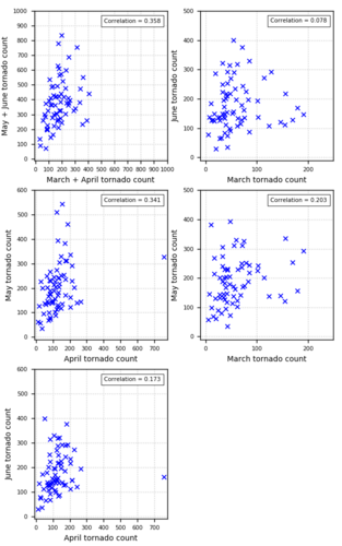
monthly_tornado_scatter_spring.png
 
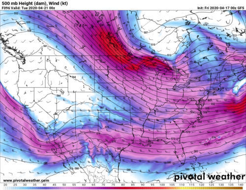
With historically low model performance this year, it seems like anything outside of Day 4 is fantasyland. We have seen setups trend up moisture by almost 5 degrees the day before the event, lows slow by 300 miles within 24 hours, and ensembles flip flopping every day. With lack of UA data it seems pointless to try and forecast anything outside of 100 hours. GFS wants to hint at something mid next week into the following weekend but I don't know if I believe it. On the other end of the spectrum, there is some agreement with the Euro with mid next week but 5-10 degrees lower on dews and flip flopping every day. Until this mega east and south troughing BS is proven to go awayI'm going to assume it will stick around for at least the foreseeable future, since every time the models try to get rid of it it comes back.

1587095879789.png
 
The latest ERTAF discussion isn't particularly encouraging for Plains chasing prospects going into May. Overall, medium and long range model guidance continues to suggest a rather quiet regime across the Plains as we enter prime chase season. The lack of deep convection over the Indian Ocean doesn't bode well for chase prospects. Is this going to end up something like a 2014 where you get one good system in June and that is pretty much the whole season? Time will tell, but I am definitely a little bummed at this point.
 
Photogenic tornadoes swarming the FL peninsula on April 20 is a good snapshot of the early season pattern this year. We've thus far had a small handful of real opportunities in the Plains focused in TX, and they've largely underperformed. The next two days offer some conditional/marginal potential in TX/OK, but overall, the pattern heading toward May 1 appears lackluster at best. But, needless to say, the heart of the season is still too far out to call with any confidence. A relatively wet cool season has led to minimal drought coverage on the Plains, which is a positive.
 
So this is the time of year I begin to follow the Plains moisture -- instead of the larger Global signals. It's still too early to think about sneak attacks out west, but that day will come soon. Nothing will happen, no matter how dynamic the system, if the RH sucks. Once the RH is in place out west, anything can happen. I took a quick peak at the GFS RH forecast and it's looking good for end of April through the first week in May. There does not (ATM) appear to be any gargantuan systems ripping down from the north to scour the moisture into the Gulf for a week and the Hudson Bay Low has gone on vacation. :)
 
I do the same thing. It’s quite a drive for me to get to the plains and when I do go down I stay for a while. Because of that, I pretty much only look at the dew points to decide if I’m going down. If it’s May and if you’ve got the moisture, something will be happening. On the flip side, nothing is going to be happening without the moisture. If I’ve got a few days with moisture in place the rest of the details will usually fall into place.
The plains have pretty much been left out so far. That will be changing soon. The GFS and CFS have both been pretty consistent with the gulf being open for business at the beginning of May
 
Agree we are inside the seasonal guessing time-frame. However I still would like to see some convection come out of the Indian ocean over Indonesia (Maritime Continent). Right now the 6-15 day forecast is pretty northwest flow. Honestly I'm cool with it. Dixie needs a break.

Weeks 3-4 from NOAA/CPC and the weekly models look tough; however, they have very low verification scores. Anything can change. Some new convection is percolating in the western Indian Ocean off Africa. A New Hope Episode 4-ish.

Air fare remains reasonable to the Plains late May early June (likely lifted travel restricions then). It's not nutty cheap like between big markets (where they have to keep even empty planes flying). However it's about 1/2 to 2/3 off last year! I might just book to ICT and hope for the best.

I strongly prefer floating vacation over fixed trips. However I'm really tired of that 14 hour drive (not even chasing). I've got friends and plenty of bust activies in Wichita; so, I have greater than average bust risk tolerance. Might just book flights and hope for the best!
 
My post on 4/20 was doom and gloom for the season, but after what transpired this past week I am much more optimistic for May. It does look as if we may see an active period during the first week of May. It appears western CONUS troughing may finally become established with multiple waves ejecting into the Plains. Goodness, I was ready to throw in the towel just 5 days ago.
 
Some years are just active. I mean we got a Hudson Bay / Great Lakes trough in April; but, it's still producing in the Plains. That's gotta be a good sign the Atmo just wants to produce this year.

I concede that's not very scientific. Drivers more likely include the active southern branch, without raining out, AN SSTs in the Gulf, and adequate moisture return thanks to no true Plains drought. One would think west of I-35 will become seasonably active in May.

Finally recent NOAA/CPC weeks 3-4 forecast (caution it's fickle) has a slightly more optimistic look than weekly model forecasts. I infer they are looking for MJO convection to eventually come out of the Indian Ocean and cross Indonesia (maritime continent).

Can't wait to see the ERTAF discussion Sunday evening.
 
Well, u guys just keep up the positive talk, I really need it to treat my SDS. Also, I am considering the possibility of taking advantage of my summer plans being shelved because of COVID to drive over to tornado alley with my chase partner for the first time towards the end of May, weather permitting. Any tips and tricks on how to do it on the cheap greatly appreciated.
 
Latest indications are some breakdown of the east troughing as we enter the first and second weeks of May, however this currently looks like primarily meridional flow with some perturbations that will likely lead to a couple of typical early May mesoscale driven events. GEFS does want to hint at some continued western troughing as we enter mid may, but still has that east troughing that if occurs will likely screw with the surface patterns that are typically conducive to big May tornado days in the central/high plains. Outside of that, not much you can really say with model performance this year. Last week proved that even with a pretty poor pattern you can still squeeze out some quality tornado days, albeit east of I-35. Will continue to monitor this season one week at a time, however it does look like there's some hope on the horizon.
 
Victor Gensini's GEFS SCP forecasts chichlet chart showing nearly across-the-board negative SCP coverage anomalies throughout the entire medium range (up through the first 10 days of May). Predictability limits and all, but that makes it look like below normal activity is likely through the first week of May.

Certainly nothing in the CFS chiclet charts suggesting any obvious signals of any upcoming events in the next 8-10 days. But pretty typical numbers for total SCP >1 coverage.
 
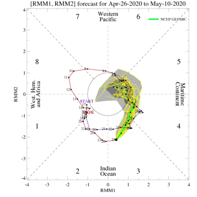
Should add...MJO phase diagram also makes it look like at least a short downtime is ahead of us.

I don't perfectly remember what is featured in each phase, but I know that the 8-1-2 progression promotes the kinds of synoptic scale patterns most conducive for convection/severe convection over the Plains. And that's what we just came out of, and we saw what happened over the past twoish weeks. Therefore, I presume that the 4-5-6 phase promotes the exact opposite, and that seems to be exactly where things are headed over the next 10-14 days.

ensplume_small.gif

Bummer since I'll be participating in week 1 of the HWT spring forecasting experiment this week...remotely, of course.
 
GFS Has a habit of nailing down a few risk areas in the 6-10 days range and once locking on like a dog with a bone does not let go. The days of 4th and 5th May it has been showing now from T264 down to T168 so this to me looks like it has gotten hold of something. In Late April 2016 it did this with the Wray Set Up

Looks to me a deepening low pressure with low 70's dewpoints being pulled North West into SW Kansas and Western Oklahoma and a sharpening dryline. Soundings very favourable as well.

2 Days to watch maybe................
 
Last edited:
Status
Not open for further replies.
Back
Top