State of the chase season 2020

Status
Not open for further replies.
Hello. I am Nebraska weather enthusiast. I have been reading this forum to see what you all have to say about the 2020 storms season. Based off the guidelines, I know I am not supposed to be on this forum since I am a beginner, but I am really curious about the upcoming season so I felt like I could hazard one comment and then not comment again. Here goes......

Is this season going to be good in Nebraska? Is this nasty spring pattern of trough east/ridge west going to mess up June or is there hope?

Thanks,

Ben Janssen
 
Besides a generally unfavorable upper level pattern the next 2 weeks, we also have very warm surface temps out west that will become a cap as the air moves east over the plains. I hope I have to eat these words and at least get a chase early next week but not holding my breath.
 
It's not quite the same evolution as last year due to the *very* northward displacement of this year's NPJ, but I'm getting a bit tingly if the MJO dynamical fields can hold on and result in a nice increase in convection over the maritime continent. If this propagates toward the dateline, we should be very much in business for the back half of May.
 
Really hard to believe the models right now as far as poor upper level flow for mid-May. Climatology still has a say. I believe this will change, even if it's NW flow over eastern Colorado and western Texas, I'll take it. Don't see any indication of the dreaded El Fireball de Mexico cap sneaking up in the 700mb flow.... yet.
 
No concerns for late May travel chasers. Tough to sugar coat the next 7-12 days, but a lull is not uncommon. Whether it goes the full 15 days is TBD. GFS is useless that far out. GEFS and EPS members are far from unanimous after Day 12.

I share the optimism of Dr. Gensini (post above and ERTAF disco). Look at the Himawari and Indian Ocean satellites shows two areas of convection in the Tropics. The one over the Dateline is the cause of current angst. Ahh, but let your heart not be troubled...

New flare up is in progress over the Indian Ocean. It should lumber slowly toward the Maritime Continent / Indonesia. NWP keeps pushing back the impacts, but it's coming. If the Dateline stuff calms down as the IO stuff pushes out, we're in business late May.

I have a personal rule, no travel chases before Mother's Day. Personal calendar opens up much better after that anyway.
 
I don't buy the SPC forecast for this Saturday. IMO there is no way we don't get storms forming over IL, then tracking into IN around sundown. Both GFS and NAM showing low to mid 60's dews, with 1000 - 2000 ML CAPE in IL, 500 - 1500 ML CAPE in W IN. There are not great 500 mb flow, but an imbedded area of 60 kts over central IL/IN seems good enough to me. The shear is piddly until you get into IN, so I would expect storms to form over IL, then track into IN right around dark and maybe with the increased shear there we get lucky on something. Let me know what you think.
 
They say chance of just general thunderstorms, with an SBCAPE over 1000... That's the part I don't get. But anyways, really the only relevant forecast is the one they make day of.
 
Happy May Day! NWP is hinting at some split flow the week of May 11. That can get sloppy, cold fronty, and otherwise challenging before May 15. However, it's better than the upcoming Tue-Sat. While May is starting relatively quiet, it's not dead.

For after May 15, weeklies are split in clusters ranging from a ridge to southwest flow. Majority are still some sort of split flow, which is more doable after May 15. It's less bust or slop prone especially after May 20 (a date that lives in infamy 2019).

Took at close look at the Indian Ocean IO after the Weeklies came out last night. Going from east to west, convection in the West Pac remains a problem for chasers. Wave in the eastern IO is about to cross the Maritime Continent MC and may interfere with the West Pac stuff to create the progged split flow week 2.

I'm most interested in weeks 3-4. Tough to discern just yet, but new convection may be percolating in the western IO - with more separation from the first two. Could that promote late May fun? Need a couple more days to see if that western IO holds together.

Bottom line. Week 2 (May 11th week) should have a couple set-ups, but maybe not outbreaks. Weeks 3-4 are peak climo and I remain optimistic. Even average is active late May.
 
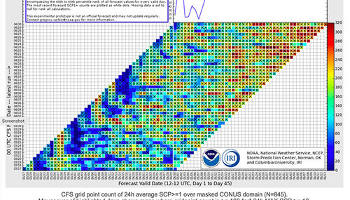
CFS also likes the second half of May -- although I'm not really impressed with anything right now and the GFS is off the rails after next week (hopefully). Might be great timing to have a dude (or delayed) season because of the virus situation. Still think the usual suspects will pop up as in recent drought "style" years, like the Midland Vortex and eastern Colorado in June. It's just too damn hot here in Arizona right now, something has to give.

Screen-Shot-2020-05-01-at-9.39.20-AM.jpg
 
Ignoring the generally dismal 7-10 day period ahead, I'm becoming somewhat concerned about the green-up/evapotranspiration situation on the High Plains whenever a reasonably favorable pattern returns. April was cold and fairly dry (e.g., 0.12" at AMA; 1.00" DDC; 0.30" GLD), so we have short-term precip deficits during the crucial green-up period that will likely continue building through the next week. The NDVI Greenness page I like to reference hasn't been updating lately; not sure if anyone else is aware of similar resources elsewhere.
 
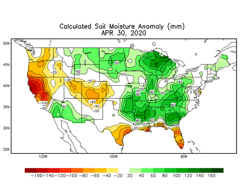
Soil moisture link? Here is one I have used.

Thanks! Not sure how I've missed that before now.

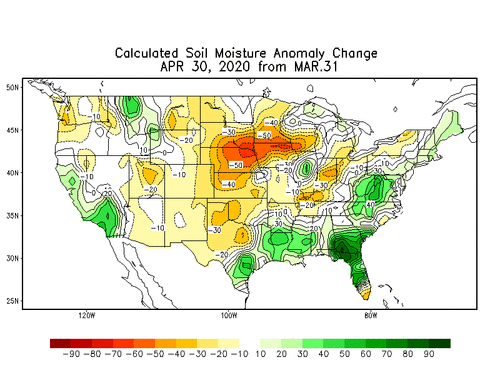
I'm attaching a snapshot from 4/30 for future reference. Soil moisture is tending drier than normal in the central High Plains, and fairly close to normal further south into the Panhandles. The anomaly change from 3/31 to 4/30 shows that the NW flow pattern over the past month has not been, and will continue not to be, helpful.
 

Attachments

  • curr.w.anom.daily.gif
    curr.w.anom.daily.gif
    24.5 KB · Views: 0
  • curr.w.chg1.daily.gif
    curr.w.chg1.daily.gif
    26.9 KB · Views: 0
Ignoring the generally dismal 7-10 day period ahead, I'm becoming somewhat concerned about the green-up/evapotranspiration situation on the High Plains whenever a reasonably favorable pattern returns. April was cold and fairly dry (e.g., 0.12" at AMA; 1.00" DDC; 0.30" GLD), so we have short-term precip deficits during the crucial green-up period that will likely continue building through the next week. The NDVI Greenness page I like to reference hasn't been updating lately; not sure if anyone else is aware of similar resources elsewhere.
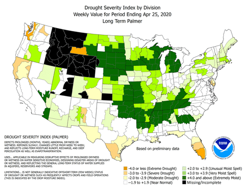
FWIW, it doesn't look terrible everywhere, but doesn't look great in the areas you'd like to see it nice and moist.

palmer.gif
 
Status
Not open for further replies.
Back
Top