State of the chase season 2020

Status
Not open for further replies.
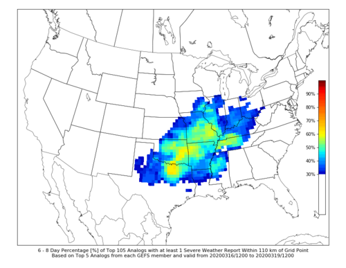
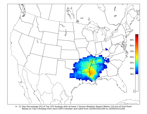
In addition to the ERTAF forecast linked above by Jeff (valid 3/15-3/20), CIPS extended range has also pegged a similar area for a relatively high frequency of 1 severe report in nearly the same area (Southern Plains, Mid-Mississippi Valley, and Southeast). I think is the first period this spring where various guidance has shifted activity westward and northward. CIPS guidance valid 3/16-3/19 and 3/19-3/22 below.
 

Attachments

  • Severe_6_to_8_day.png
    Severe_6_to_8_day.png
    145.1 KB · Views: 0
  • Severe_9_to_11_day.png
    Severe_9_to_11_day.png
    143.6 KB · Views: 0
Here's an article that was posted today conveying the same information.

 
After a tornado outbreak in January and February and the really bad one in Tennessee where iam, it's off to a good start. Looks promising, hope it's an interesting season
 
Models have been all over the place with the details (what else is new?) so SPC is still reluctant to commit to an area on the 4-8; but there's a good possibility there will be some sort of system resulting in some sort of severe threat (about as specific as I can get at this point) traversing the central CONUS late this coming week. From my standpoint, taking today's 12Z GFS verbatim timing and location currently don't look ideal for a chase opportunity, but something to keep an eye on at least.

If things come together right it could end up being something like 3/15/16, but right now the surface low and instability axis are portrayed too far west. 500 mb looks somewhat eyebrow-raising, though.
 
The surface and 500 mb charts on the last few runs of the GFS valid for 00Z Friday (Thursday evening) would have me salivating if instability/lapse rates were a little more robust. Still, 60 degree dewpoints to I-80 with that amount of shear is worth keeping an eye on.
 
CIPS extended analog guidance based on 03/24 00 UTC GEFS shows March closing out and April beginning with cooler and dryer conditions than normal across approximately the eastern 2/3 of the CONUS. Latest ERTAF guidance and discussion also paints a bleak picture for the first part of April. Obviously there could be relatively smaller, subtler events here and there, but the large-scale pattern for the next few weeks looks to be less than ideal for regularly occurring severe activity.
 
CIPS extended analog guidance based on 03/24 00 UTC GEFS shows March closing out and April beginning with cooler and dryer conditions than normal across approximately the eastern 2/3 of the CONUS. Latest ERTAF guidance and discussion also paints a bleak picture for the first part of April.

If there was ever a time to have lower than normal activity, I'm glad this is it. Also hoping a relatively inactive March and April will transition into a more active May/June. Seems to be (and this has been discussed before, but it bears repeating) that March/April and May/June activity are somewhat negatively correlated - it is rare that both periods are busy or both not busy. So usually, having a quiet early season means a good chance of an active mid-late season (one testimonial example in each direction: 2006 and 2010).
 
With a trough in the East this week, the state of the non-weather threads is a dumpster fire. Oh but there's hope for next week.

ECMWF Op and EPS have both trended toward a West trough in the 6-10 day. MJO convection supports that shift. Models are finally picking up on convection near/over Indonesia. That's a winner for US storm chasing.

GFS is now onboard too, not that I really care what the GFS has. OK cynicism aside, model agreement is a plus. Make fun of models, but be kind to one another. We all love weather and storms!
 
Yeah...based on the latest ERTAF outlook, it looks like the first half of April is looking to be pretty quiet. Good. Keep the quiet times coming. Open the flood gates starting mid-late May so we can all see something this year!

I want Oprah levels of supercells and tornadoes on multiple days in May and June.
 
Hoping that April is just active enough to keep me sane, i.e. one or two tornado days, then late May and early June be active. See 2016. Nonetheless, I'm definitely no long range expert, but the CFS and GEFS/EPS ensembles appear to indicate some west troughing with potentially an open gulf in the 4/10+ timeframe. I'd gladly take a 5% tornado or two in KS at this point. Anecdotally, the early season west troughing activity with deep lows and only mild southwest drought would lead me to guess that this season bears some resemblance to 2019. At least so far it has seemed to be the case. I recall 2019 also had a number of days where the EML was prevalent early and cap prevented some otherwise hefty setups from producing. Again, this is all anecdotal but so far from a pattern and even tornado numbers standpoint we appear to be picking up where we left off in 2019. I personally would favor some more big, long trackers but out in open fields of course. I'm still waiting at my chance for redemption for largely not being able to chase in 2013, and I'm still waiting for my first EF-4+ tornado.
 
Recent CIPS extended guidance output for the Day 6-8, 9-11, and 12-14 period signal troughing in the west with severe activity across the Southern Plains, Great Plains, and Midwest. This has been the trend over the last few days, so we'll see if it holds.
 
ECMWF Op had a weird run overnight 00Z 1 Apr. Unless the Centre does an April Fools joke. However the Ensembles remain more bullish for that 6-10 day trough West and surface low Plains. Sizable minority of the EPS is like the crazy Op. However the majority is still on board.

The 11-15 day isn't looking so great on the EPS, but we'll see. GFS/GEFS is more optimistic, but less skilled.
 
Well this thread is dead, kinda like the Plains season so far.

Seriously. I understand the COVID-19 situation is hampering many chasers' ability to chase and consuming much of our lives to varying degrees, but it's still nice to talk about something other than the virus now and then.

The most recent ERTAF outlook valid for 4/19-4/25 has an Above Average (AA) area that includes parts of the Plains, Midwest, and Southeast (https://atlas.niu.edu/ertaf/). CIPS extended guidance valid over that same time frame suggests a pattern favorable for severe weather across a similar area, albeit a little more focused on the Southern Great Plains. The CFS Dashboard has been showing a gradual increase in favorable severe environments through the latter half of April and into May (CFS Severe Weather Guidance Dashboard). I can't say I look at this guidance often, so I can't comment on how notable it is or is not currently, but I feel it looks promising for the heart of the season.
 
Last edited:
Status
Not open for further replies.
Back
Top