State of the chase season 2020

Status
Not open for further replies.
B Janssen said:
general TSDS (thunder storm deprivation syndrome).
I think I'm getting that.
LOL
Still waiting the 1st thunderstorm of the year to come to me.
Having seen lightning way off in the distance on a couple recent nights just makes it worse.
Need a storm of my own...
 
Yes Ben you are interpreting the CFS correctly. Whether it's right weeks 4-6 is another question, lol! Generally the weekly products add some statistical value out to week 3. In the dead of winter or peak of summer - in stable patterns - they can add value week 4. By adding value I mean verifying with a significant correlation to realty when week 4 becomes this week.

Nice tie in to my next point. Which trough should one chase. We have one the end of next week; but, it's prone to all the risks of the first trough (moisture, cap, surging CF). On the other hand it could be grand. I'm calling trough #2 the one currently progged (subject to change) around May 16-17 - perhaps lasting into May 18-20. I like that one, but my gut can be wrong. Some weekly products (and tail end of ensembles) have yet another one late that week. Well that's week 3 almost week 4 when verification drops. A bird in the hand is worth more than one in the bush.

Obviously if one lives out there, chase all 3. Rest of us need to make a choice. I'm not even considering #3 yet. Based on #1 questions, does #2 count as the bird in the hand? Or be literal, the first one is the bird in the hand. Still a few days to make the call. Even if one flies, air fare is cheap right to walk-up. No reason to rush decisions.

As in any year, driving offers maximum flexibility. Just need to start downloading audio-books. One possible consideration. Kansas Ad Astra Plan (re-opening) begins Phase 2 the week of May 18. Storm chasing is already socially distant, but Ad Astra is a potential tie breaker.
 
Jeff, where are you looking at these models? I am using COD, which only shows CFS and GFS, not their ensembles. I don't see the troughs you are talking about.
 
The models are in pretty good agreement of kicking things off next week for the Plains. I'm liking that the NCEP Ensembles are breaking down the ridge and offering up favorable upper level flow after the 14th onward. Should be daily risk of dryline storms in that time period. I would not be surprised if something pops on the dryline earlier than the 14th. Edit: CFS is also liking this period > 15th.
 
The models are in pretty good agreement of kicking things off next week for the Plains. I'm liking that the NCEP Ensembles are breaking down the ridge and offering up favorable upper level flow after the 14th onward. Should be daily risk of dryline storms in that time period. I would not be surprised if something pops on the dryline earlier than the 14th. Edit: CFS is also liking this period > 15th.
about time. Not much action here in Nebraska at all through april or this month at all.
 
Jeff, where are you looking at these models? I am using COD, which only shows CFS and GFS, not their ensembles. I don't see the troughs you are talking about.

Joey try Pivotal Weatherhttps://www.pivotalweather.com/model.php

Not sure it will have everything you are looking for but check it out. I believe the page linked to above defaults to GFS. Just click the blue icon that says “GFS” and you’ll see the other models available.
 
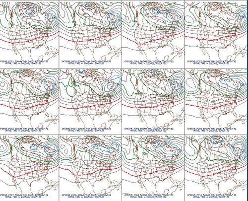
Speaking of the ensembles the past few runs of the GFS have been in general agreement for western troughing/SW flow aloft next Wednesday through Friday, here’s the latest 500MB Height run for 2020-05-14-00z:

GFS ENS.jpg

Latest GFS run for the same time shows decent SW flow aloft, mid to upper 60 dews along a dryline from western Kansas down through western Oklahoma into Texas. Yeah, it’s still a long way off and even if it verifies synoptically other variables can complicate but for the last few runs there finally has been decent potential worthy of watching and I’ve got fingers crossed for my first plains chase trip of the year!
 
I am very excited for my first plains trip ever. My chase partner and I are planning to head down probably on Tuesday, be in position to chase Wed - Sat. Anyways, It looks like the storm season is about to crank up again, finally take advantage of all that moisture sitting over the gulf.
 
Suspect Tuesday will be a happy hour event for the Plains as the season finally gets cranking. I won't be able to attend as the soonest I can depart is Tuesday afternoon for Wednesday+ chasing. Upper levels looking good for an extended period with only the surface and cap features to be determined. Can't remember the last time models held so much RH to the west through the extended. Could be an old time dryline fest if things hold -- something that has not happened in years.
 
Suspect Tuesday will be a happy hour event for the Plains as the season finally gets cranking. I won't be able to attend as the soonest I can depart is Tuesday afternoon for Wednesday+ chasing. Upper levels looking good for an extended period with only the surface and cap features to be determined. Can't remember the last time models held so much RH to the west through the extended. Could be an old time dryline fest if things hold -- something that has not happened in years.

Warren, I was kinda wondering the same thing given how far west there's been a significant amount of precipitation over the last handful of months. Definitely something I haven't seen in a while and I'm hoping I can get a day or two off to chase at least something in this sequence.
 
Looking at medium to long-range ensembles, the signal for a potentially active pattern is really quite strong(especially given the range) and it's hard not to like what is being shown. First off, subtle system coming into the west next week will probably yield some chase worthy days with a potential lull for a few days over the weekend.

By weeks 2/3 things really get interesting, the modeled jet extension starts to come into play here and this is where that super consistent -- both run to run and model to model -- signal is located. Northern hemispheric pattern is also following a rather textbook evolution that tends to lead towards active periods for plains severe wx potential and supports this evolution. The current ridge over the Yukon/Alaska slowly retrogrades with time and ultimately ends up somewhere over Eastern Siberia. Furthermore, a ridge looks to build to a limited degree over Hawaii, with multiple strong waves crossing the pacific on a track for the western US courtesy of an active jet. Looking like the long-range could evolve into a fairly active stretch and given the range there's really quite the signal for it. It also makes sense with AAM/GWO transition but the mechanisms of how AAM and tropical forcing mettle with patterns is not my cup of tea (though to be fair none of this hemispheric stuff really is). One last thing is that the AAM/GWO transition is not as amplified as last year which might mean that the resulting pattern is not as amplified (someone correct if wrong), and if that is the case, combined with an Actually Present EML™, could set up a really nice chasing period. I'm obviously very optimistic.

However, one thing that does put me on hold here is the tendency for low latitude troughing to show up on some ensemble runs. The gulf is cooking this year so whether or not this actually has any significant effect with such a strong gulf and being in the second half of May remains to be seen, but it is there off and on and is worth noting.

But for now, let's just treat ourselves with this.

6edb7a96067f93a39d5feef157a48f29.png
5223f12995b17c1575d8944b9781b12a.png
802ceae5f5e957f33e23733e4c5dbf32.png


18z GEFS pacific pattern gif just because:

d0301a7c9356e572bf4dddf143d8c048.gif
 
Despite having chased since 2009 (mainly on tours though) I have had a hard time getting my head around and REALLY understanding forecasting. I looked into the upcoming week and despite my ignorance I could tell it did not look promising at all. It is, in fact, encouraging to read that the knowledgeable and experienced people here on StormTrack confirms this.

The reason is that today was supposed to have been my first day of chasing on a 7 day vacation and it has been really tough accepting the fact I won't be chasing this season (obviously due to Covid-19). Knowing that it not just will be so-so weather but in fact hardly chaseable weather makes it easier. I would still go if I had the chance, just for the sake of vacation, the road, and the slight chance of a good storm - but picking a complete down week for a chasecation would have been really tough as well.

All the best of luck to you all who will in fact chase this week and this season in general. I hope to see some amazing videos and photos in the end. I will do my best to catch a water spout down where I live in Sweden!
 
Two decent troughs are forecast (generally). Approach approach conflicts are nice. Wednesday through Saturday is covered by the SPC and CPC. Week of May 18th is less clear, obviously the 8-15 day.

GFS Op has some flaky runs May 18th week; cut off lows Southeast, ridgy Plains, West rough not making it into the Rockies, etc. However the GEFS members are majority better than that noise. ECMWF Ensembles (EPS) generally have an even better look than the GEFS for the May 18th week. EPS has true southwest flow and a proper SER.

I'd love to just trust the EPS; but, we have a complication in the West Pac. Both have a tropical cyclone TC impacting the Philippines. Questions remain how that interacts with the West Pac jet. Also TCs can confuse the MJO forecast. Weak TCs are just like more convection. Strong TCs lower confidence.

Despite these details questions, I believe the back half of May will be seasonably active or better.
Jeff, where are you looking at these models? I am using COD, which only shows CFS and GFS, not their ensembles. I don't see the troughs you are talking about.
I get the ECMWF and its Ensembles from a work subscription. As others note, I believe free Pivotol includes the ECMWF now.
 
Status
Not open for further replies.
Back
Top