State of the chase season 2020

Status
Not open for further replies.
The more I look at Saturday the more I think it could be a pretty decent day. Good veering wind profile and H5 winds even pushing 40kts in KS along with big instability. GFS continues to want to displace the moisture farther east from the dryline. Not sure how much I buy that. Again, it will be interesting tomorrow when this set up is in range of the NAM. If we don't end up with moisture/LCL problems I think it has potential to be a good day.
 
"Forecast Discussion: No significant signals are present for other than average conditions for week 2. This concludes ERTAF 2020".

That doesn't sound very optimistic to me. This week into Memorial Day will be the last dance until sometime in early June. Mesoscale accident time my friends.
 
Pulled the plug yesterday am for chase operations this season, barring any June miracle. The SPC and models still support my decision, with next week looking like the end of the regular season. Good luck to everyone on the long shots -- I have no doubt someone will nail at least one good tornado before the season is over. Colorado, Wyoming and the Dakotas are still in play for June - maybe.

First time I've missed a season in 32 years of chasing. It's times like this when you realize you still love chasing even after all those years. It's truly the little things that matter, like the drive east from Tucson though the mountains of New Mexico and peaking the last hill on highway 380 where the Plains suddenly open-up before you.

I still have the monsoon and hurricane seasons, although I'm not getting on a airline until there is a vaccine or I test positive for antibodies (getting tested today).

Good luck to everyone.
 
Not to go OT and cross into the realm of the "storm chasing and coronavirus" thread, but I'm curious Warren as to how much of a factor covid is for your decision? Is it fair to assume that your threshold criteria for chasing is a little higher than normal this year, and that absent the coronavirus you would be out there rolling the dice and chasing for whatever little there might be? There promises to be at least some action over the next few days, hard to imagine you giving up on that, maybe covid is even the primary driver of your decision?

I'm simply not impressed with any of the models over the next 5 days, including the reflectivity modeling for the next 2-3 days. Saturday and Sunday show some promise. It's pretty hard to justify a plunge based on "mesoscale accidents" as Mark said. If there was a better solution next week, I might have taken the chance on this week. COVID did play into the decision, by making it easier to nix the season. Not having my friends out was a serious consideration and hotels are still a risk, if not more than a week ago, as places like AMA are now "hot zones." I would still consider a June chase if there is a week of good chasing, but none of the models support that right now -- except in the far north were the roads are few and far between.
 
I feel really bad now Warren. I should be careful what I say because you certainly are a better forecaster than me! The AFD for Denver today is talking about two inversions and backed winds at the mid levels, which isn't good for severe to form off of the dryline. It seems more like a surface trough to me than a dryline but I can't argue with those who are paid mets at the NWS. I really hope that something happens in June, which is 12 days away at this juncture, as I know how much you love chasing. Fingers are crossed for June to pan out.
 
Pulled the plug yesterday am for chase operations this season, barring any June miracle. The SPC and models still support my decision, with next week looking like the end of the regular season. Good luck to everyone on the long shots -- I have no doubt someone will nail at least one good tornado before the season is over. Colorado, Wyoming and the Dakotas are still in play for June - maybe.

First time I've missed a season in 32 years of chasing. It's times like this when you realize you still love chasing even after all those years. It's truly the little things that matter, like the drive east from Tucson though the mountains of New Mexico and peaking the last hill on highway 380 where the Plains suddenly open-up before you.

I still have the monsoon and hurricane seasons, although I'm not getting on a airline until there is a vaccine or I test positive for antibodies (getting tested today).

Good luck to everyone.

As a truck driver, I can attest that there's something to be said for that view when you exit the Rockies onto the plains.

I missed most of the 2016 season due to training to get my CDL, so I can definitely sympathize with you on that. Saturday may be my last opportunity for a while, as I don't get enough time off work to make plays from Nebraska and points north. After this weekend, my best opportunity will probably be late summer when I'm on vacation in Indiana, where there are usually some form of either mesoscale accident or NW flow event.
 
I plan on leaving Saturday to go chasing. I'm working on getting my car prepared now. At this time, I plan on starting in Nebraska on Saturday, and then working my way south into eastern Kansas or Oklahoma on Sunday, and then Texas on Monday. I know, it's still way to early to know for sure what's going to happen. But this is my plan for now, just based upon how Saturday is shaping up, and my experience with how these setups move around this time of year. I can't chase all week, so I'm hoping for a good weekend. And *hopefully* chaser convergence won't be too bad on this Memorial day weekend.

I am concerned this whole weekend could be a bust though. Saturday looks like it might have some shear problems - resulting in MCS rather than an isolated supercell. But who knows? We could get another McCook. If Monday looks like a complete dud, or if the storms move too far east, I'll just head back home so that I can make it back to work on Tuesday.

Honestly - this whole season has been so quite so far. I'm really just hoping for some awesome June opportunities in eastern Colorado / western Kansas near my house where I can just leave after work and go chasing. Right now, I'm just so ... bored.
 
With my reluctant decision to punt this weekend, I look again to the MJO, Ensembles and Weeklies. This weekend will have tornadoes. I'm just not sure about visibility or duration. Prefer a chance at multi-cycle, over single cycle within a cluster of other storms (and chasers).

MJO is a mess but a Kelvin Wave blasted through the Indian Ocean recently. See if it can help. Otherwise the EPS has some members with a Northwest trough late toward Day 15. Climo suggests that'd eventually be a Northern Rockies/Plains deal. No reason to think it dives into the Four Corners for the Central Plains.

Both weekly products CFS/ECMWF do have that coming across for the Northern Pains the work week of June 8. Barring a cut-off low debacle that seems like a reasonable progression. Second week of June might be less crowded too.
 
I've been wavering on whether or not to chase tomorrow, but I think I will (70% chance I will). I couldn't go out today because I'm getting my car repaired, so hopefully tomorrow still gives me something.

I'm targeting the dryline in central / western Kansas. My biggest concern this whole time has been a lack of lower level shear. The GFS and NAM both put shear around 40 - 45 kts, which is enough for some weak tornadoes. But we just entered the outer bounds of the HRRR, and it's only showing 25 kts. Hopefully the models come in agreement tomorrow and give some better confidence.

I've been concerned that the SPC isn't mentioning this area (makes me think I'm terrible at forecasting), but I read the discussion for that area, and they are just marking it as 5% severe chance right now because the models are not in agreement. They plan on updating it later once they get better confidence. I also read through the different AFDs for the local WFOs in Kansas, and they all say they have no idea what's going to happen and that Saturday is very difficult to predict.

The fact that the SPC isn't really mentioning this area yet makes me happy, because it means chaser convergence might be lower as people target Nebraska instead. Without a clear target area, and without a strong tornado chance, I think tomorrow is going to come down to some localized meso plays - if we get anything at all. That said, CAPE and moisture are both there, and upper level shear is good too. So even if we don't see any tornadoes, the structure should be awesome. I just have to avoid the hail :).
 
Welp...yyyyeeeaaaahhhhh...

She hasn't taken the stage yet, but the fat lady has been warming up for the past few weeks just off stage right. She's ready to go now...just waiting for the stage manager to give her the final cue to come on and sing the swan song of the 2020 season.

I recognize that we still have June (and, for the northern Plains, July, but lol to that), so it isn't over quite yet, but at least from the last several G(E)FS runs I've seen (consistent with the CFS), unless things pick up to an absurd level in mid-late June, this season is done. Worse than that, 2020 will likely compete (among those here who have been around long enough to have seen it) with 2009 for the worst peak season in memorable history for storm chasers as a group.

Don't look at the SPC WCM page's annual daily count of severe weather reports, because it does not reflect the quality of the traditional Plains ("Tornado Alley") chase season. The biggest outbreak so far this year was in Dixie, and pretty much all of the most notable events were east of the Mississippi River (and south of the Mason-Dixon line).

Ugh. Just, ugh! UGH!

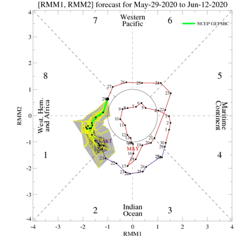
To be fair, I see this MJO forecast...
ensplume_full.gif
But that's just one small, proxy piece of information that has yet to bear any fruit. Also, that's at a pretty long range, so things could change.

So, yes, I have hit my breaking point and lost faith. I'll be the whiner to cry it out explicitly (although Warren basically said it, too, last week): "the 2020 season is over...known before Memorial Day"

I invite everyone to join me by listening to the first episode of my new podcast* "You Know it's Gonna be a Bad Year When..." where chasers lament modern chase season quality and reminisce about the days of old when synoptically evident setups presented themselves in the NWP guidance 3-5 days out and the dryline reliably produced pretty supercells every few days of May. Each episode** will discuss one aspect of how chase seasons suck; the first one will be called "It's after 2011"***.

*Given my blunt and plainspoken tone, I understand not everyone will get that I'm not actually doing this.

**Again, not actually doing this.

***Seriously. This is not real. Don't look for this podcast. Instead, look for a thread about this.
 
Last edited:
I've been watching the models like a hawk, and looks like there has been some consistency for some action in the Central and Northern plains around 6/5 - 6/6 and a stronger wave coming in after that. ( I know I know) Of course wish casting, but heck, Im here in California just itching to see some great storms! I backed out of the last round because the 500mb winds were looking lackluster but at least we got our tickets completely refunded which is cool and unheard of.We had round trip tickets from LA to Dallas for $48 round trip! Insane!! So, I am hopeful for a mid June Jaunt to the pains. I have never Chased in ND or Montana or Iowa or Minnesota, so, this may be the year for that. Anyway, just a glimmer of hope that's all!
 
Yes a northern Rockies to northern Plains trough remains forecast starting next Saturday (give or take) June 6th. Set-ups may be hard to forecast until a day out. Could be anywhere from Cheyenne Ridge to western Minn. Also lots of moving around and repositioning, or sitting out a day, which occasionally can mean sacrifice a set-up.

For terrain help it's not just the Palmer Divide and Cheyenne Ridge. Bighorn and Sawtooth Mountains can also help farther north in upslope conditions. Then over in the Northern Plains it sometimes likes to go earlier than it would central/south, another challenge for positioning the night before.

I probably won't participate, but will virtually target. One of these years I'm going to wait and go far North in June.
 
Hmm...MJO forecasts showing we have arrived at the beginning of phase 8, with a transect through phases 8 and 1, and possibly getting to 2. Could signify a temporary increase in conditions favorable for severe weather soon, although I don't know how well this methodology applies at this time of year. Also, the forecasts suggest we may not see phase 2, which might reduce the degree of support for severe convection.
 

Attachments

  • ensplume_full.gif
    ensplume_full.gif
    32.7 KB · Views: 0
Still a fair amount of convection in the IO as well per the loop. This would appear to be good news for June but you never know until it gets closer. What does it mean when the MJO forecast is dinking around in the middle of the circle in the graph @Jeff Duda? I recall many a chase day in the central high plains during the latter half of June and into July in past years. Not everyday type of chasing but decent chances to make or break a season. The monsoon moisture tends to create another moisture source during the summer so hopefully we’ll have a chance to put last Saturday behind us if it all works out!
 
Still a fair amount of convection in the IO as well per the loop. This would appear to be good news for June but you never know until it gets closer. What does it mean when the MJO forecast is dinking around in the middle of the circle in the graph @Jeff Duda? I recall many a chase day in the central high plains during the latter half of June and into July in past years. Not everyday type of chasing but decent chances to make or break a season.

In the MJO phase diagrams I have been posting, the inner circle has a radius of "1" for the measurement of the components of the MJO. Anything inside that circle means the signal is too weak to be classified as an MJO cycle. So if the data falls in there, then the MJO signal is neutral as to its effects on North American convective coverage modification.
 
Status
Not open for further replies.
Back
Top