State of the chase season 2020

Status
Not open for further replies.
The monsoon moisture tends to create another moisture source during the summer so hopefully we’ll have a chance to put last Saturday behind us if it all works out!

Moisture has been a huge problem outside of the southern Plains this year. Due to the highly amplified pattern leading to Oprah-style cutoff lows, large-scale moisture return has been absent, which has led to pitiful moisture west of I-35/US-281 outside of the southern Plains. Until that situation is ameliorated, it almost doesn't matter if we get a decent trough to cross the Plains because storms will be muted.
 
Hmm...MJO forecasts showing we have arrived at the beginning of phase 8, with a transect through phases 8 and 1, and possibly getting to 2. Could signify a temporary increase in conditions favorable for severe weather soon, although I don't know how well this methodology applies at this time of year. Also, the forecasts suggest we may not see phase 2, which might reduce the degree of support for severe convection.
Thanks for posting this event though I have no idea at all what this little graph is I am looking at? Can you please take a few moments and explain what I am looking at or share a link with more info? Thank you!
 
Here is one link describing the MJO. Another good website with several model charts is here. It's very interesting to learn about the MJO and the effects it has on the mid latitudes of the CONUS. I cut my teeth on this phenomenon when I was a member at WeatherBell.com and read what Joe Bastardi had to say about it. Enjoy!
 
Here is one link describing the MJO. Another good website with several model charts is here. It's very interesting to learn about the MJO and the effects it has on the mid latitudes of the CONUS. I cut my teeth on this phenomenon when I was a member at WeatherBell.com and read what Joe Bastardi had to say about it. Enjoy!
Thank you @Mark Blue! Appreciate it!
 
Well Saturday definitely looks to be in play across the central & high Plains (mainly NE, but probably some part of WY/CO/KS/SD will also end up seeing some kind of threat as well). Trough appears to finally make it far enough east and spread some good flow far enough south to get into some great quality moisture. It has been showing consistency on the deterministic GFS.

The GFS is also consistent with a period of increased troughiness through the medium range, and especially from next weekend and the following week. I even see a trough with 60+-kt h5 flow going across OK roughly the 10th! It appears to be associated with a strong cold front for June, though. Very strange.
 
Last edited:
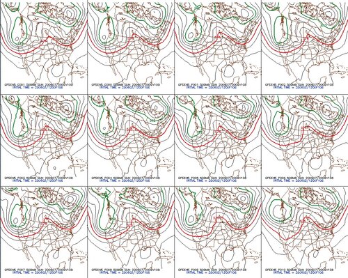
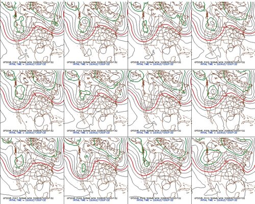
It’s still early but yes, not only does Saturday look to have potential so does Sunday as well. The deterministic GFS has been consistent over the last couple days and GFS ensembles have been in general agreement on trough placement as well. Cherry picked forecast soundings each day are off the charts and while I don’t put much into them it appears the forecast in general shows high enough potential to plan a trip.

GFS Ensembles for 20060607/00z & 20060608/00z:

GFSE 0606.jpg


GFSE 0607.jpg

I’m already blocking off Saturday through Monday for the first 2020 plains trip, crossing fingers it actually happens.
 
Yes Saturday appears to kick off a muli-day chase from the High Plains to the Midwest by early next week. SPC is on it and deterministic models depict it.

As I write today, Thursday, this could be that famous day or two before the day. Moisture is a little light, but trying to recover. MCS outflow could promote an isolated tornado Thursday.

Saturday looks more substantial with a true trough, good wind shear, and adequate moisture. Sunday should be an encore still in good terrain thanks to the slow moving main trough.

Next week action shifts to the Mississippi Valley. Upper trough will be on the move. Merging with Cristobal remnants complicates things. However Cristobal will bring some extra low level shear.

That's a huge region but it is a multi-day event. Perhaps one could use Monday as a repositioning day for the Midwest. Skip the Deep South.
 
Likely going to cancel both the tornado season and the Cristobal offerings and focus on the Monsoon and August / September Hurricane Season. Saturday looks like a first-class chase day and the northern Plains can produce some spectacular tornadoes. Just too far for a 1-2 day chase, in addition to poor road networks in the region and COVID risks, which everyone seems to have forgotten about.
 
I really want to chase the setup this weekend in the Dakotas, but I would like someone to chase with/caravan with for a chase of that length. I recently tested negative and have all the PPE (mask, gloves, etc...) I have a car and no time commitments, so just let me know if this interests anyone.
 
We successfully navigated through two different reservations yesterday here in SD. There are closed roads, but the nice people did let us go through. One guy really was being a jerk for no reason at al. Just flexing. We were patient, and told him we were chasing, so he went to get his supervisor and I heard the supervisor say, “of course they can drive through. They are chasing and reporting storms. They are essential” storm chasers deemed essential! BOOM!
 
Last edited:
This weekend looks like it will have very high bust potential. 700 mb temps are very warm (14-16C common). In general, H7 temps of more than 12C means the cap will be very tough to break. Once you get into the 14C range that is almost unbreakable, barring a really strong cold front or some other type of help. Both days offer this kind of cap, and this capping inversion is quite visible on forecast soundings with a strongly stable layer just above the surface. Keep in mind, when you start seeing maxed out parameters (supercell composite, sig tor, etc) it is usually a sign that the parcel is capped off.
 
This weekend looks like it will have very high bust potential. 700 mb temps are very warm (14-16C common). In general, H7 temps of more than 12C means the cap will be very tough to break. Once you get into the 14C range that is almost unbreakable, barring a really strong cold front or some other type of help. Both days offer this kind of cap, and this capping inversion is quite visible on forecast soundings with a strongly stable layer just above the surface. Keep in mind, when you start seeing maxed out parameters (supercell composite, sig tor, etc) it is usually a sign that the parcel is capped off.

That rule of thumb generally only applies east of -100 W longitude, where terrain heights are lower. On the high Plains 12-14 C isn't really unbreakable. Something closer to 15-17 becomes pretty hard to break, though.

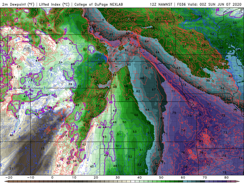
I think the bigger problem with bust potential for this weekend's setups is the drought and subsequent poor moisture over the Plains. In a better year, we wouldn't be seeing such moisture starved systems with narrow moisture tongues, and everything east of the dryline would have 60+ dews. See the forecast for Saturday as an example:

NAMNSTCGP_sfc_dewp_036.png

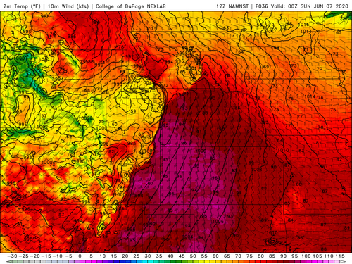
If you compare the dewpoint map to the temperature map, the surface wind pattern suggests there is a classic SGP "dryline" extending from W NE through E CO and down into NM, but the good moisture is 100-300 miles east of that line in the dewpoint field. Imagine filling all that green shaded area of SW NE/W KS/PHs with the blues and maybe some purples in a better year.

NAMNSTCGP_sfc_temp_036.png

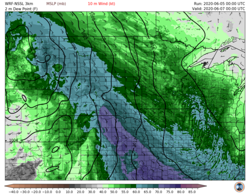
That, to me, is the bigger reason these events could bust. We have to hope for Saturday that the moisture tongue ends up being a bit further west (as is shown in the NSSL-WRF below)...

sfctd.spc_np.f04800.png

...so that existing storms in NC NE can access that better moisture before weakening with diurnal stabilization (or the storm mode becoming completely linear).

I apologize for this post trending towards belonging in a forecast thread. I may end up moving it.
 
Yeah, I mean June and we're having moisture problems? C'mon.
It's 2020. EVERYTHING has problems.

Nothing about this weekend really looks all that appealing. A lot of forcing over meager/narrow moisture and messy storm mode over tough terrain. Then Sunday looks like it has more storm mode issues. Currently looking at the possible trough next weekend that I'm sure will disappoint as well, as it looks like it may be more of an omega block than a trough that will eject over the plains.

At least we still have booze.
 
Status
Not open for further replies.
Back
Top