State of the chase season 2020

Status
Not open for further replies.
Even if May 22-25 is good, it'll be four of about six days this year. Oklahoma had a couple gems in April. Everybody who grew up in the Plains remembers it's more active 20-30 years ago. Hell Kansas used to get wedged in March, Hesston. Now a birdfart in May?

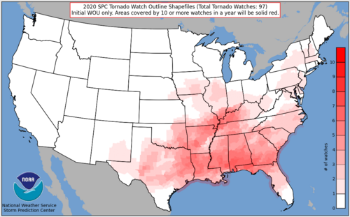
All I have to show so far from 2020 is almost getting hit at Midnight by the Chattanooga tornado. It was 2 miles to my northwest, but I never even looked. Nighttime, rain-wrapped, Dixie; and, I didn't believe it until it happened. Guess that's my 2020 tornado. Sad!

At any rate it seems a very late May early June pattern is already shaping up after the Tennessee Valley cut-off low stops grinding through the East. Modest flow looks off and on vs a constant out of the Southwest. LLJ is shown each night, which is one positive. Moisture is also shown better than progged a couple days ago. We'll see.

DDC's afternoon discussion highlighted Memorial Weekend. Models would seem to support some type of higher-ended event over the holiday weekend in Central Kansas.
 
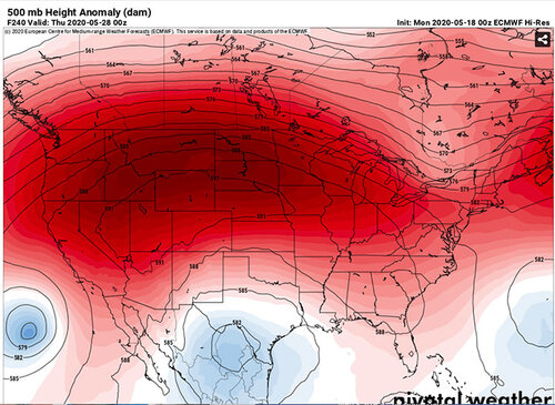
The main takeaway for me from today’s 12Z runs, SPC, and various AFDs is the crux of the energy and upper flow will be displaced too far north. It’s still four days out (mid-week) but I’m picking up on a trend for the trough and its low to dilly dally in the Pacific NW, before arriving as a closed low by the time it finally makes it east of the continental divide. A low in the SE has been known to screw up deep moisture return in years past, so it has to move out so the blocking ridge can break down more effectively. It could end up being the first northern plains chase in 2020 but it does sound like the west TX dryline will also be in play offering at least a look at convection each day beyond Wednesday. Timing of the ingredients coming together is crucial with this setup. Hopefully the flies in the ointment will fall away one by one and we’ll have at least two or three good chase days to work with by Memorial Day.
 
This was discussed a week or two ago with reference to the MJO teleconnection and the 8-1-2 pattern. It appears the
Indian Ocean convection has gone hog wild. I’m not sure how long it takes to translate across the globe, but better late than never. Two day loop

A family of cyclones is always a good thing. I’m looking forward to the one up in the Bering Sea island chain, which should be a major player if a trough can carve out and make it to our latitude before shearing out.

View attachment 20512

I believe it was Lance Bosart who presented a colloquium seminar at OU when I was a PhD student there. He talked about teleconnection patterns and highlighted that the Kamchatka-Okhotsk Sea area is one of Earth's synoptic scale "erogenous zones" - areas that when perturbed even slighly, tend to cause a Rossby wave train to form that spans the Pacific and North America, usually causing a string of big troughs to traverse the continent. What you're showing almost looks like that. But...that is largely a cold season phenomenon. So I'm not necessarily expecting something quite that dramatic. I do see a Pacific jet extension in the longer-range GFS, but the predictability on that is nil.

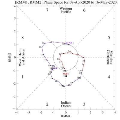
I lost hope after seeing the MJO die off in phase 6 about 10 days ago and become forecast to be stuck there. But, indeed, it has sprung back to life:
obs_phase40_small.gif

Unfortunately, the GEFS forecasts another phase-3-4-5(-6?) wave progression from here, which is generally pretty unfavorable for promoting severe weather in the US. Let's hope the local pattern can overcome that added forcing (i.e., mesoscale driven setups may be key, as we may not get much help on the synoptic scale).

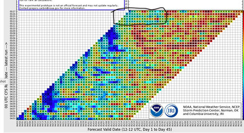
FWIW, the GEFS SCP chiclet diagram shows a 2-3 day period of above active in the US late next week, before a forecast of another quiet period after that. Let's hope something emerges during that time. The actual 18Z GEFS from this afternoon does seem to continue to like that same period (basically Thursday and Friday), but the uncertainty becomes pretty high starting next Saturday.
 
Spent a fair amount of time going over the various models tonight including the 12z GFS. The models paint a very active period in good chase territory beginning Thursday, running through Sunday. (Wednesday could be a sleeper). I'm not as concerned about RH as I was earlier, as both the GFS (and more-so) the ECMWF-Hi-Res. maintains 60+ DP's in the Texas Panhandle or vicinity though peak heating for multiple days. Obviously there will be the usual monkey wrenches, but that's chasing. The ECMWF extends some level of risk though at least the 26th, which is full blown sorcery, but what the hell, it's the end of May. One more peak at the 12z tomorrow and it's game on.
 
GEFS continues to be pretty bullish for Friday and Saturday. The deterministic continues to look pretty mediocre with moisture problems, high LCLs, capping issues, instability displacement, and overall lack of shear. I can wait until tomorrow morning before I have to make the call on whether or not to take Friday off, but right now I'm not real confident. It'll be interesting to see what it looks like once it's in range of the NAM.
 
GEFS continues to be pretty bullish for Friday and Saturday. The deterministic continues to look pretty mediocre with moisture problems, high LCLs, capping issues, instability displacement, and overall lack of shear. I can wait until tomorrow morning before I have to make the call on whether or not to take Friday off, but right now I'm not real confident. It'll be interesting to see what it looks like once it's in range of the NAM.
Thursday and Saturday appear pretty favorable.
 
Thursday and Saturday appear pretty favorable.

My general rule of thumb is I don’t get too excited until the models start painting supercell composites of more than 7 over a decent area. Not saying lower numbers can’t get it done but there are reasons the numbers aren’t higher for the end of the week
 
Friday is in range of the NAM now and it favors an area in southern OK right now for decent severe potential. It is tough to tell if the NAM is doing its usual thing and overplaying moisture return with mid 70's dewpoints. Mid level flow is still pretty weak but perhaps a bit better on the NAM than the GFS. Based on the NAM I pulled the trigger and requested Friday off from work.

Edit: Looks like the dryline in KS on Saturday could be decent based off the 12z GFS now too. Hopefully a couple of days of chasing before things shut back down
 
Last edited:
Keeping in mind Jeff Duda's caveat that we're all susceptible to warped perceptions when "everything looks like shit" for awhile...

I'm becoming cautiously optimistic that we'll luck out later this week, despite a woeful hemispheric pattern. In particular, most NWP guidance has trended toward every day from Thu-Sat (5/21-5/23), and potentially even Sun (5/24), offering opportunities. None of those opportunities currently looks like anything near a guaranteed quality chase setup. By late May, however, the quantity of days with opportunities counts for more than it gets credit for (see: Bennington, Campo, the same period in May 2016, etc.).

Thursday and Saturday both offer setups that seem to have some classic synoptic elements and a relatively high ceiling, but in my estimation, there are complications that make it seem unwise to start hyping just yet. Specifically, any slowing of the incoming shortwave Thursday could have a substantial negative impact, while Saturday appears susceptible to early convection and messiness. Friday looks fairly interesting in less desirable terrain, pending antecedent convective evolution. By Sunday, a surging cold front may undercut most of the decent flow aloft, but perhaps areas like E KS or IA can squeak out a fourth day worth watching.

After that, at least several more down days lacking any opportunity appear likely, and we're left to hope June can outperform the reputation it's earned over the last decade. Thus, a whole lot rides on this upcoming series of low- to moderate-probability chase days, and anything from elation to heartbreak is on the table.

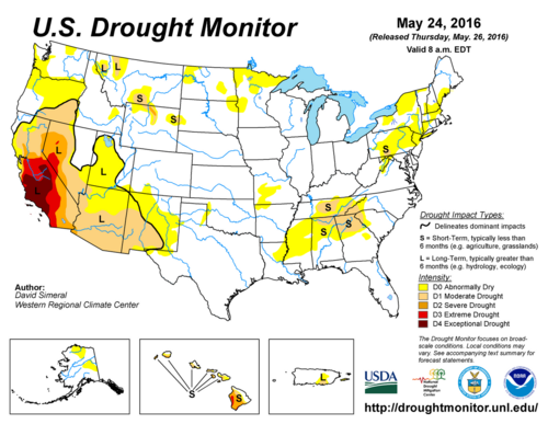
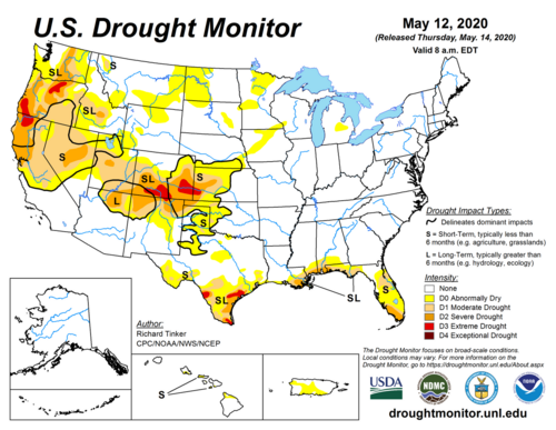
In the spirit of hard realism, I have to say the drought situation on the High Plains tempers my hopes for this week's finesse-type setups some. In 2016, when five consecutive days produced photogenic storms and/or tornadoes in that region with fairly modest WSW flow aloft, vegetation was clearly in better shape in terms of transpiration to tamp down on afternoon PBL mixing.

20160524_usdm.pngcurrent_usdm.png
 
Status
Not open for further replies.
Back
Top