State of the Chase Season: 2019

Brett Nickeson said:
we all bake under a cloud of mosquitos.
Those little vampires are fairly uncommon where I live .lol. I saw less than a dozen of them for the whole summer last year.

Marc R. O'Leary said:
I'm ready for June in Colorado. Bring it on.
(plus I cant go camping at my usual spot because theres several feet of snow still on the ground.)
So am I. Its time for some good warm/hot weather.... Need to get my garden planted - its finally warm enough at nights for that.
(no idea if/how much snow is left where I go camping, but its still getting kinda cold up there)
 
I, too, would be interested to hear any updated thoughts from subseasonal experts on the mid-late June time period. While a short break is typical following a stretch like we saw in mid-late May, the duration of generally extremely unfavorable tornado conditions stretching from late last week into at least early next week is frustrating. It takes very little in June to produce at least localized favorable/targetable conditions, particularly with the upslope regime in CO/WY. Only a complete lack of upper flow, or an unseasonably strong northerly component to the flow (i.e., major eastern troughing), can really shut down the Plains this time of year. Of course, we're now in the midst of a 10-14+ day stretch featuring periods of both.

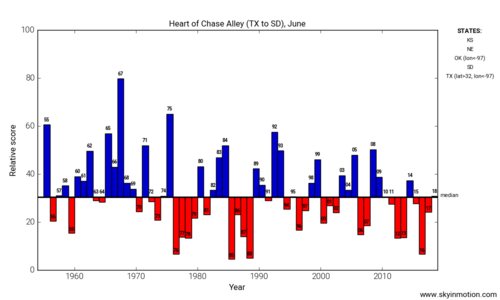
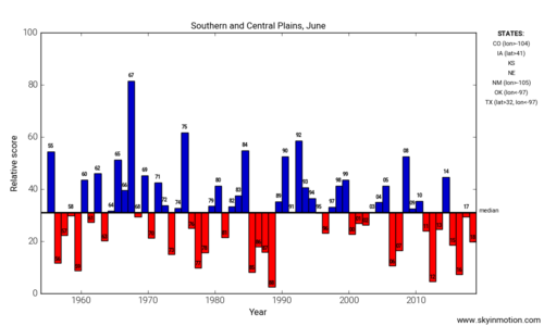
The frequency of quiet Junes this decade has to be concerning for chasers who long for the high CAPE/low shear, northern biased, less crowded, endless string of opportunities this period of the spring traditionally offers. It's really a shame, because this is when we often see all the conditions that maximize chasers' wishes while minimizing the attendant risk to public safety. I decided to re-run my chase season scoring script with data through 2018 to get one perspective on how June has performed from a tornado-day-focused perspective.
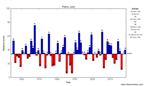
plains_jun.png

For the entire Plains, Junes in the 2010s have not been especially terrible; though certainly not great.
heartalley_jun.pngscplains_jun.png

When focusing east of the upslope regime ("Heart of Chase Alley") or from NE/IA southward, it has been pretty bad, with only the late 70s-late 80s being comparably bad. 2010 and 2014 have really been the only memorable Junes where the span from KS to ND/MN saw numerous good days. It would be interesting to hear from more seasonal/climate-focused researchers and mets whether any oscillations on the decadal timescale could plausibly explain why the late season has generally been subpar recently.

All that said, June 2019 still has time for recovery starting in 7-10 days, though I wouldn't call the ensemble signal at that range right now especially exciting. All we really need is 30-40 kt of zonal flow at 500 mb cutting across the Plains somewhere, though, so we're likely to manage that sooner or later. Even in the meantime, there could no doubt be some needles in the haystack in the coming days -- and anyone willing to drive more than a few hours for these setups will have earned their prize, that's for sure!
 
Those little vampires are fairly uncommon where I live .lol. I saw less than a dozen of them for the whole summer last year.

So am I. Its time for some good warm/hot weather.... Need to get my garden planted - its finally warm enough at nights for that.
(no idea if/how much snow is left where I go camping, but its still getting kinda cold up there)
I JUST got my garden planted.

Last time i camped was October....i had to clear 6in of snow from my favorite spot. I called Park County yesterday and the road to my camp area isnt even open...i guess its fall camping again for me.
 
Brett, great post, I have to agree that it has been quite disappointing since Tuesday, May 28 (we elected not to chase in the trees of northeastern TX or anywhere near DFW on the 29th). My chase partner and I couldn’t start our chase vacation until the 23rd, so we missed the 17th (McCook NE) and 20th (Mangum OK). We did have six good chase days in a row from the 23rd through 28th - without much success in the tornado department, but we have only ourselves to blame for that. Still, as others have said, the overall pattern did not quite live up to the high expectations for the period.

Regardless, at the end of that stretch, I still had another 10 or 11 days left on my chase vacation, potentially my longest trip ever. Never did I expect (although I always feared) that it would already be pretty much over for me after just one week. Some good moisture in NM went to waste in recent days, that’s for sure. It’s a shame 500mb flow was so weak, you really don’t even need much for some magic to happen on the High Plains given sufficient moisture/instability but there was little more than a light breeze in the mid-levels up.

We actually ended our trip early; I flew home from Denver to Philadelphia yesterday after migrating back toward Denver on the previous two days. I do regret not sticking around long enough to chase NM on Monday 6/3 or Tuesday 6/4, especially after being down there already on Sunday. On Monday, SPC did not even include NM in a 2% tornado risk, and for Tuesday the models were showing mid-level flow to be even weaker. So we blew off both days, figuring we would target southeast CO (which actually did have a 2% tornado risk) on Monday and then just continue on to DEN on Tuesday. But while heading north on Monday I tortured myself watching several TOR-warnings west of Roswell; there were no confirmed tornados, but I’m sure the supercells looked pretty good structurally (not sure if these were separate and successive storms, or the same one, I wasn’t monitoring radar all that closely). Then on Tuesday, SPC corrborated the weaker flow yet still put up a 2% TOR probability in NM despite not having one the day before, and there was a confirmed TOR, again west of Roswell. Ugh.

But it’s always too easy to second-guess yourself with the benefit of hindsight; that’s one of the most frustrating things about this hobby. Fact is, for me there comes a time on a long chase trip when work and family responsibilities begin to pull you back home... If some true possible tornado days were likely, I would have stuck around and dealt with the consequences later, but when I feel like I’m just jerking around with obligatory chases on marginal days, staying out becomes harder to justify. And as much as I love chasing, there comes a point when I lose my motivation to even make the effort on such marginal days.
 
Models are in agreement on sending a moisture-scouring front to the Gulf next week. The upper pattern also doesn't look encouraging through the end of the medium range. I hesitate to call the season just yet, but it sure doesn't look good for anything more than the typical post-spring mesoscale/2% days.
 
Last edited:
Models are in agreement on sending a moisture-souring front to the Gulf next week. The upper pattern also doesn't look encouraging through the end of the medium range. I hesitate to call the season just yet, but it sure doesn't look good for anything more than the typical post-spring mesoscale/2% days.

In...bloody...JUNE.

No disparagement meant to those who scored in May, but from where I stand, 2019 still hasn't been that great. Better than 2018 and 2017, yes, but that's a pretty low bar to clear.
 
Last edited:
The overall pattern looks unusually quiet across the Plains through about next weekend, or the day 7-10 range. This is reflected well by the CFS severe weather guidance dashboard, which has blue boxes in the coming days, something that is very unusual for early to mid-June.

Some spotty severe thunderstorm activity will be possible from the Northern Plains into the Upper Midwest this weekend, as a trough ejects eastward. What happens with that trough next week is the glaring issue. Medium-range guidance and ensembles are fairly consistent with broad troughing across the Missouri Valley/Midwest/Great Lakes vicinity through much of next week. In uncharacteristic form for the time of year, instability appears limited through at least the middle of next week and possibly the end of the week as well. Northwest flow events are not totally uncommon in mid-June, but with modest instability, at best, that does not bode well for severe thunderstorm prospects.

There have been signs that the pattern shuffles around next weekend and that there could be a return to at least near average severe thunderstorm activity for the third week of June. European ensemble data and the weeklies, to a lesser degree, show a more zonal flow-type pattern across the northern tier of states by next weekend or early in week 3. (roughly the June 15-18 window) The potential may exist for one or a few shortwaves to impinge on the northern High Plains/Northern Plains vicinity with an uptick in severe potential there. This is also highlighted by the CFS dashboard, although it does not take much in the way of wind shear to throw blanket regions of elevated SCP values in June when there is seasonably-typical instability in place.

With that said, the latest Euro weekly data seems to imply that any pattern shift is temporary and that more Upper Midwest/Great Lakes troughing could set up by the middle or end of June week 3.

As we go deeper into the season, troughing in the Great Lakes/Midwest vicinity could result in northwest flow severe threats from the Missouri Valley region into the Corn Belt, but that type of pattern needs instability in place. The trends suggest that moisture is going to be scoured south and east (quite a feat for June), even when there is appreciable upper level flow in the northern states. Who knows, maybe that could result in an unusual late season threat across the Mid-South, but that's speculation on a conditional presupposition.

Any way you slice it, it's hard to be excited for Plains chase prospects. Sure, you can get some High Plains magic here or there, but that's to be expected, even in the quietest months of June. I'd be cautiously optimistic about prospects for June week 3. On the bright side, that period (June 16-22) has featured some significant events over the past decade. Almost each year seems to have at least one noteworthy event in that window, but we'll see.
 
In...bloody...JUNE.

No disparagement meant to those who scored in May, but from where I stand, 2019 still hasn't been that great. Better than 2018 and 2017, yes, but that's a pretty low bar to clear.

Agreed. Seems a lot like 2013, with all the activity condensed into a relatively short portion of the overall season, actually even fewer days: 5/17-5/29 in 2019, 5/15-5/31 in 2013.

In 2013 I was fortunate that my chase trip was exactly during that most active period, whereas this year I couldn’t get out until 5/23, missing McCook 5/17 and Mangum 5/20.

During the time I was out this year, the only real tornado days in traditional chase territory (ignoring IA/IL and the trees of northeast TX / southeast OK) were 5/23 (Canadian TX) and 5/28 (Tipton and Lawrence KS). Even in 2018, one could have had three consecutive great tornado days (Wyoming, the multiple CO landspouts, and Dodge City).

There are other posts above that talk about the deficiency of many of this year’s setups, especially relative to the overall synoptic pattern that was in place.
 
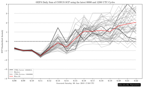
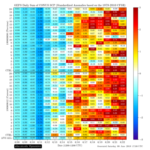
Seems to be a decent signal amongst the operational guidance for a couple of subtle disturbances to move through the Plains and amplify the low level flow and moisture return towards the end of next week (generally 6/14 onwards). This follows the amplification of the eastern trough during the early/mid section of next week. This has been reflected in the GEFS members for quite some time regarding the period that Quincy was mentioning.

Raw SCP is biased by CAPE this time of year, but standardized anomalies of the field are a bit more representative of potential upticks in activity (via Dr. Gensini's page). A similar, albeit stronger, signal proceeded the active period in the latter half of May.

gefs_std_anom_scp.png
gefs_scp_stda_chiclet.png

Kind of looks like the type of pattern that has yielded some slow moving monsters in the past. Worth also noting that we've had a difficult time getting cap busts this year, which may actually work in favour in subtle forcing events as opposed to the stronger forcing we saw in the May sequence, given that background thermodynamic conditions haven't changed markedly from May.

Another point to make is how often early June (specifically, the first 10 days) has been a dud recently. Aside from the flukey Laramie tornado last year, since 2010, I cannot recall an early June period that has been especially memorable.
 
Last edited:
As Andy pointed out above, there could be a couple of discreet gems coming up starting late next week. There’s nothing screaming that there’s an outbreak coming up, but that’s OK. There’s a pretty stiff cap forecast for late next week through the week end in the Kansas, OK and Northern Texas where a low looks to be stalled out while the gulf starts returning moisture. The better winds seem to be separated from the top notch moisture and forcing, but there looks to be enough to crank out a couple of isolated supercells a few days late next week and weekend. At the very least there should be some nice structure and maybe a couple of quality tornadoes. It’s a ways off, but it looks like the kind of setup where a slight day pays off big time for those who look for the discreet details.
 
Another point to make is how often early June (specifically, the first 10 days) has been a dud recently. Aside from the flukey Laramie tornado last year, since 2010, I cannot recall an early June period that has been especially memorable.

Yeah...taking my vacation from June 8-16 in 2015 and May 30-June 7 in 2016 worked out so well for me. Almost historically dull stretches for that timeframe based on climo, 2016 stung with DDC/Chapman having been the week before.
 
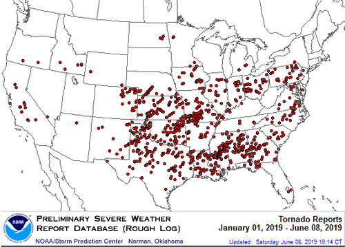
I'm starting to wonder if the Northern Plains will even have a chase season. Typically by mid June the region (WY, MT, SD, ND) will have seen around 30 tornadoes. So far there have only been 5 this year. Also, while Colorado has seen some brief touchdowns, none of them have been quality tornadoes that I'm aware of. The GFS isn't showing anything coming up, although the CFS is a bit more optimistic. I haven't lived here long enough to compare 2019 to previous years. Will there be more storms in July to make up for this quiet period?
 

Attachments

  • 2019_annual_map_torn.gif
    2019_annual_map_torn.gif
    19.1 KB · Views: 0
Back
Top