Best photos of 09 chase season

  • Thread starter Thread starter Jason Boggs
  • Start date Start date
Rotating updraft on the northeast part of a storm in north central Nebraska- May 20th:
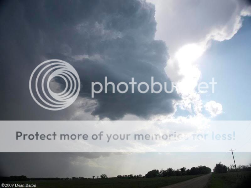
5-20-09554.jpg


Incredible structure on a tornado warned storm west of Waseca, MN- June 17th
_6170848.jpg


July 13th- Tornado warned storm in central South Dakota, this is the storm that would go on to be the Valentine storm, had to bail on it due to zero road options south.
_7130956.jpg


July 13th again, the severe warned supercell north of the storm in the previous pic, definately different looking but still a very cool storm.

_7130982.jpg
 
We didn't have a great year for tornadoes but we got a few decent pics along the way. Here are just a few.

3763733221_94aa62c9d9.jpg

Lightning from July 27.

Apr25011.jpg

A high based supercell near Corn, OK on April 25.

3645836608_dee52db113.jpg

Incredible LP supercell just 30 miles from home on a surprise chase that bagged me a small tornado.

3512326333_da7893fc95.jpg

Just a random shot at a developing supercell near St. Joseph, MO on May 7.
 
Here are a few for me....had a handful of incredibly unspectacular and unphotogenic Tornadoes this year (minus the two on April 26)...but quite a few decent days mixed in. I'll post five non tornado pics since my pics from the 26th aren't near as good as many since I didn't have a good vantage point for either. Facebook quality I'm using here sucks...but I'll post five from there since I'm retooling my website.

3191_688891094657_9618123_39734505_6347227_n.jpg

March 23 near Crescent, OK

3191_688891099647_9618123_39734506_3280149_n.jpg

April 25 near Willow, OK

3191_688891189467_9618123_39734520_5857280_n.jpg

May 1 near Seymour, TX

6612_718880615417_9618123_41089005_1796139_n.jpg

August 17 near Geary, OK

6612_718880630387_9618123_41089007_1429884_n.jpg

August 17 near Geary, OK
 
This wasn't one of my best years, but it was still enjoyable.

#1
Arnold%20NE%2009-3.jpg

23 June 2009 near Stapleton, NE Supercell


#2
Arapahoe%20County%20Tornado.jpg


7 June 2009 Tornado South of Byers, CO.


#3
LaGrange%20Tornado%2009-1.jpg


5 June 2009 LaGrange, WY Tornado rope out.


There are ALOT of really great photos posted here. My favorite 3 would be Mike Hollingheads Truckstop Meso/Lightning, Scott Weberpals June 7 CG Shot, and Jeff Snyders June 9 Meso shot near Dodge City. Another that is one of my favorites that isn't posted here is Mike Umscheids "Between The Ears" CG shot taken a couple of weeks ago. Amazing shot!
 
Last edited by a moderator:
April 26, 2009 near Crawford Oklahoma tornado was by far the best tornado image I've had to date. I have not seen a similar picturesque tornado since near Edson Kansas in 2007. You would not believe how hard it is to get a tube to pose in good contrast. LOL

crawfordOK4_26_09.jpg


Next image is near Roll Oklahoma on the same date. April 26, 2009

rollOK4_26_09.jpg


June 5,2009 Goshen County, Wyoming

goshencountyWY6_05_09.jpg
 
I posted a couple months ago in this thread, but have gotten a few more since then:

chase72809-7.JPG

Above: Watrous, NM, July 28.

lightning81609.jpg

Above: Edwardsville, IL, August 16.

chase81909-4.jpg

Above: From 1 mile north of Roodhouse, IL, August 19.

The tornado picture is nothing special from a technical standpoint, as it is just a video capture, taken through a closed window due to very close CG, but what a beautiful tornado it was!
 
Ok, my year was a bust, too, but I did get some pretty cool non-tornadic pics.

A nice little backyard cold-air funnel.
funnel cloud 2.jpg

A rare terrestrial visit by the Starship Enterprise.
anvil 5-29_2.jpg

Rotating meso preceded by a massive hailshaft. (Ignore the date, I forgot to reset the camera.)
100_1788.jpg

And this last one I didn't mean to add, but I can't figure out how to remove it, so oh well.

The cool part is they were all taken within 25 miles of home. Cheap fun.
 

Attachments

  • storm 6-19_1.jpg
    storm 6-19_1.jpg
    10.2 KB · Views: 163
June 20 - Rantoul, KS:
632854888_VS3pY-L-0.jpg


May 29 - Somewhere in Texas, about 100 yards north of Mexico:
548298632_LMMrf-L.jpg


June 20 - Rantoul, KS:
632861734_EvgUZ-L-0.jpg


May 13 - Southwest of Kirksville, MO
632367757_X5zun-L-0.jpg


May 15 - Leawood, KS:
632325127_qXrjA-L.jpg


May 27 - Western OK:
548310352_ymEmz-L.jpg


June 17 - Sabetha, KS:
632838928_db42w-L.jpg
 
Last edited by a moderator:
One of my more disappointing years, but I'll throw in a couple shots.

May 29 2009 - Minisupercell near Champaign, IL.

3577246073_c6f23571f6.jpg


April 23 2009 - Near the wind farm in southwest McLean County, IL

3469489763_bd9fe27b79.jpg


March 23 2009 - Herrington KS early supercell.

3381574866_a5db84133e.jpg


August 19 2009 - My girlfriend Tia navigating us towards a tornado warned supercell. Not a storm, but there is something beautiful about the girl I love eye balling the radar as we approach a storm and enjoying herself. :)

3838127583_64c1c9dacc.jpg
 
Not a storm, but there is something beautiful about the girl I love eye balling the radar as we approach a storm and enjoying herself. :)

3838127583_64c1c9dacc.jpg


You're lucky to have a girl like her to enjoy storms with. Don't let her get away!!!
 
Judging by what all of you have posted thus far, if I didn't know any better I would think that 2009 was the best season yet. I won't lie in saying that I have been hesitant on adding to this thread. My year though colorful has IMO been one giant meso fail since I am unable to travel far. So as for the following pics, the first three had not been seen until I posted them on Facebook a few weeks back. Since they were well received over there, I figured it would be safe to do so here.

June 18th, Decatur IL - from outside of my work a little after 6AM looking SW on a tornado warned cell wherefore the meso/WC (out of frame to the right) just missed us by about a mile. As mentioned on FB, disregarded for the awning but came back for the activity being expressed.
IMG_7124a.jpg


June 19th, Atwood IL - Just a shelf out ahead of a svr warned squall line but I like where the angles are all going.
IMG_7190a.jpg


June 19th, Forsyth IL - Another shelf but this time along the CF after dusk. Despite no warnings, liked how the various lighting works in this shot.
IMG_7284.jpg


Rare shots..?

March 11 - Ice spike on patio furniture forming as result of overnight flash freeze behind passing weather system. Can't say I've seen too many of these. It was only about 1.5 inches long, used the 58mm macro attachment. Vinyl chair slat was only about an inch as well.
IMG_2807.jpg


May 7 - Unusual swordfish looking wall cloud over Assumption IL. Got a really good time lapse of this feature at the end of this video.
IMG_5288a.jpg


September 8 - Double flyby of the ISS and Shuttle Discovery. Get those shuttle shots in while you still can!
IMG_0559.jpg
 
Last edited by a moderator:
Back
Top