Dissipated Barry Discussion Thread

Keep in mind, for those who aren't used to it. The euro image I showed above has winds at 850. You have to extrapolate down, so surface winds will be lower.
 
Looks like we have recon flights scheduled tomorrow.

WEATHER RECONNAISSANCE FLIGHTS
CARCAH, NATIONAL HURRICANE CENTER, MIAMI, FL.
1230 PM EDT TUE 09 JULY 2019
SUBJECT: TROPICAL CYCLONE PLAN OF THE DAY (TCPOD)
VALID 10/1100Z TO 11/1100Z JULY 2019
TCPOD NUMBER.....19-042

I. ATLANTIC REQUIREMENTS
1. SUSPECT SYSTEM (GULF OF MEXICO)
FLIGHT ONE - TEAL 72 FLIGHT TWO - NOAA 42
A. 10/1800Z A. 11/0000Z
B. AFXXX 01BBA INVEST B. AFXXX 02BBA AL92
C. 10/1700Z C. 10/2000Z
D. 28.3N 86.2W D. NA
E. 10/1730Z TO 10/2300Z E. NA
F. SFC TO 10,000 FT F. 15,000 TO 25,000 FT

FLIGHT THREE - TEAL 75 FLIGHT FOUR - NOAA 42
A. 11/0530Z A. 11/1000Z
B. AFXXX 0302A CYCLONE B. AFXXX 0402A CYCLONE
C. 11/0415Z C. 11/0800Z
D. 27.9N 87.8W D. 27.8N 88.3W
E. 11/0500Z TO 11/0830Z E. 11/1030Z TO 11/1500Z
F. SFC TO 10,000 FT F. SFC TO 15,000 FT

FLIGHT FIVE - TEAL 76
A. 11/1130Z,1730Z
B. AFXXX 0502A CYCLONE
C. 11/1000Z
D. 27.7N 88.5W
E. 11/1100Z TO 11/1730Z
F. SFC TO 15,000 FT

2. OUTLOOK FOR SUCCEEDING DAY:
A. CONTINUE 6-HRLY FIXES IF SYSTEM DEVELOPS AND REMAINS
A THREAT.
B. NOAA 42 P-3 TDR MISSIONS DEPARTING KLAL AT 11/2000Z AND
12/0800Z.

II. PACIFIC REQUIREMENTS
 
Per NWS New Orleans:

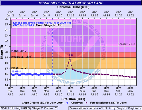
The Mississippi River forecast at the New Orleans Carrollton gage was updated this afternoon to a crest of 19 feet on Friday into Saturday to account for potential storm surge impacts on the lower Mississippi River. The forecast was closely coordinated with the U.S. Army Corps of Engineers & the National Hurricane Center Storm Surge Unit.

The city is protected to a project height of 20 feet. There is still a great deal of uncertainty regarding potential impacts, so please continue to monitor the forecast over the next several days for the latest information.
19054
 
Tropical Weather Outlook
NWS National Hurricane Center Miami FL
800 PM EDT Tue Jul 9 2019

For the North Atlantic...Caribbean Sea and the Gulf of Mexico:

1. A broad low pressure area located over the Florida Panhandle and
the far northeastern Gulf of Mexico is producing widespread but
disorganized showers and thunderstorms. Environmental conditions
are conducive for development, and a tropical depression is expected
to form late Wednesday or Thursday while the low moves slowly
westward across the northern Gulf of Mexico. Tropical Storm,
Hurricane and Storm Surge Watches could be required for a portion of
the northern Gulf Coast on Wednesday.
An Air Force Reserve Unit
reconnaissance aircraft is scheduled to investigate the disturbance
tomorrow afternoon. In addition, this disturbance has the potential
to produce heavy rainfall from the Upper Texas Coast to the Florida
Panhandle during the next several days, and interests in those areas
should continue to monitor the progress of this system. For more
information, please see products issued by your local weather
forecast office and the NOAA Weather Prediction Center.
* Formation chance through 48 hours...high...90 percent.
* Formation chance through 5 days...high...90 percent.

Forecaster Cangialosi
 
HREF members this morning coming in hot. Many of them showing a hurricane strength TC by 12Z Friday morning. The NMMB-based HREF members (3 km NAM and HRW-NMMB) are especially hot, and also unrealistic, progging a nearly cat 5 hurricane by that time! The 3 km NAM has minimum pressures << 900 mb, which is a pretty good sign that it is overdoing the development of the system. However, HRRRv3 and HRRRX also suggest sustained winds > 50 kts within 36 hours, so there does seem to be some signal in a somewhat rapidly developing TC this week. Could end up being a bigger story than initially anticipated.
 
233159_5day_cone_no_line_and_wind.png
 
The forecast landfall location of this storm is marshy lowland, devoid of infrastructure. Looks risky with any surge, even for a Cat 1. Nearby Cameron was moonscaped by Rita in 2005. Morgan City is a miniature version of New Orleans, kept dry by a ring of levees/floodwalls and always at risk for flooding from the Atchafalaya even on a good day. That being said, Morgan City is probably a decent option in this case, though flooding may be an issue for getting out afterward.
 
Last edited:
Back
Top