6/16 TALK: Panhandles/Kansas/Colorado

Joined
Mar 23, 2004
Messages
188
Location
NYC
New talk thread for todays moderate risk. It appears the moderate is for the damaging winds tonight after the supercells congeal into a large MCS, similar to last night. Oklahoma panhandle looks like a great target today. May be a dryline bulge through the area initiating convection later today if the cap doesn't hold strong.
 
Re: 6/16 TALK: Panhandles/ W Kansas

New talk thread for todays moderate risk. It appears the moderate is for the damaging winds tonight after the supercells congeal into a large MCS, similar to last night. Oklahoma panhandle looks like a great target today. May be a dryline bulge through the area initiating convection later today if the cap doesn't hold strong.

I see too much strong temperatures at 850hpa, Adam: but it never knows..

http://weather.cod.edu/forecast/RUC/SP/ruc...850_temp_12.gif
 
I made a change to reflect the potential severe in Colorado this afternoon. While hail and winds are possible in Eastern Colorado today, very heavy rains and flooding concerns are the main threat today. Storm motion expected to be less than 10kts will make for storms sitting over one area for a long time dumping copious amounts of rain. Denver's morning AFD mentions this as a threat mainly from a line from Denver to Greeley eastward, however, storms/terrain interaction could lead to some serious issues in mountain canyons and mountain towns. Also, if a slowe moving, heavy rain producing storm moves over the Urban Corridor, we could see some extreme problems in various metro areas today.

I'm not sure I'd be chasing Colorado today for chasable weather (slow storm motion is nice, but severe may be hard to find), but I would definately try my luck in the Panhandles, maybe as far north as Southern Kansas for tornadoes.
 
My boys and I are going to pile in the car and start heading out east. Our target will be Goodland, KS for today but always keeping a watchful eye back to the west at the Palmer Divide area. :D
 
6/16

Rather quiet in the target area...maybe people are satsified for 2005 finally after Sunday's cyclic supercell. Red box out for N OK, S KS, strange orientation along an old outflow boundary and pseudo-dryline towards the NW or the watch. First radar echoes returning from the TCu in NW OK. Shear profiles are good for rotating storms but I don't see a great amount of low level speed shear, maybe a storm on the boundary can come up with enough storm relative helicity for a tornado. I'm staying put today.
 
Current activity looks rather multicellular at this point. We'll see if any supercells can get organized. I'm waiting here to see if anything tries to go up in the developing cumulus field in west central OK, otherwise I doubt I'll be chasing today.
 
Severe warned cell east of Denver dumping crazy amounts of rain and probably some small hail. Storms will follow this slow moving trend all day and into the evening around here.
 
Looking WDSS here at the lab and it seems the Meade Co storm appears to be going supercellular. Overhang starting to develop and reflectivities are increasing in the low mid levels...waiting to see what happens :)
 
6/16

I'd have to disagree with the multicellular observation considering all of these storms are developing V-notches on radar and mid-level rotation. I don't like how the storms are close together at this point, but it seems they all will be riding that NW-SE oriented boundary with lower LCL's and backed low level flow.
 
Adam, not sure why so little interest - certainly looks like a few tornadoes will be likely later this evening. Morning concerns of the quality of low-level moisture were, as suspected, unjustified. Maybe last week did raise the bar too high. Cells are looking quite good on sw KS to nw OK already - and with high vorticity along the boundary, storm motions which would favor tracking along the boundary, and significant instability, certainly looks quite good to me.

Glen
 
I'd have to disagree with the multicellular observation considering all of these storms are developing V-notches on radar and mid-level rotation. I don't like how the storms are close together at this point, but it seems they all will be riding that NW-SE oriented boundary with lower LCL's and backed low level flow.

Yeah, I would agree now, but at the time of my post, they were mostly multicellular. Several of the cells are showing supercell characteristics now, as you stated :)
 
Storm in SW Clark Co/SE Meade Co, KS showing a hook there at the far west end. Weak overhang starting to show signs of forming a BWER. However, main core is vertically stacked and the lack of shear and strong winds I wouldn't surprised to see it go HP rather quickly....and as I type I see the LL structure disappear on wdss.
 
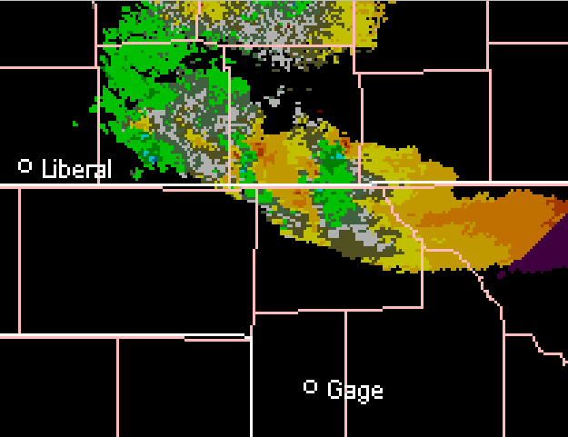
Wow, strong mesocyclone/anticyclone couplets showing up in mid-levels on the splitting cells. Very impressive :). Is it ok to post a single Weathertap image on here?

Edit: guess so, here is a pic of SRV tilt 3:

splitting_storms.png
 
There are six well defined outflow boundaries showing up on nws radar out of Shreveport. I have never seen so many in such a small area. Should be interesting to see what happens in the next few minutes.
 
I like the splitting supercells along the ks/ok border. Most impressive to me is the storm in sw KS. Current VIL max at 87 (!!!!!) with upper-60 dbz at 20,000 feet and 3.25" hail indicated. Good meso signature as well with that storm along the grant/kearny/haskell/finney county quad-border.

CAPE remains very high in the region, and the presence of the boundary may make for some very interesting storms, particularly if the storm in extreme nw OK can begin to slide southeastward along the boundary. Looking at SPC mesoanaly, the strong low-level shear (200-250 0-3km srh and resultant high SCP and Siggy Tor) lie south of the border in nw/nc OK.
 
Back
Top