cdcollura
EF5
Good day all, this is my reports for May 28, 2023 in Oklahoma and Texas...
Summary: May 28 was a seemingly marginal chase day with low expectations, however, turned out to be an extremely busy and productive day, with supercells and at least 4 tornadoes observed in the Texas / Oklahoma Panhandles! I looked at data in the morning and saw a marginal chance of supercells, with the best chances of storms near a general area in triangle from Stratford, Texas to Perryton and Guymon, Oklahoma. Winds aloft were quite light (6km bulk shear of 25 knots max), so low level dynamics and terrain were the main influences of the setup. The SPC also had this area in a slight risk, with 5% wind and 15% hail probabilities. Tornado probability was near zero (less than 2%). I headed north on Highway 287 out of Amarillo during the late morning, stopping in Dumas for lunch, then east on SR 152 to Stinnett, then northeast on SR 207 to Perryton, taking Highway 83 north out of there. A supercell was encountered early in the afternoon near Turpin and Balko in Beaver County. This storm produced large hail and funnel clods before weakening during the late afternoon. I left the storm, targeting another supercell back southwest, heading back down via NS 130 road off Highway 412 to SR 207 in Texas to head southwest. The SPC also had mesoscale discussion 890 in effect. No watch was issued. I headed down SR 207 to Spearman, then west on FM 520 / 1573 (large hail was encountered in FM 520 as the right-split dissipated there), eventually targeting a powerful left-split supercell, that moved to the northwest (extremely deviant motion), and produced significant tornadoes in Sherman County southeast of Stratford, Texas and FM 119. I wrapped up this great chase day at sunset, heading west to Highway 287, punching through an MCS that overtook the supercell storm, and fueled up in Stratford. From there, I took Highway 54 northeastward across Oklahoma, through Guymon, and into Liberal, Kansas for the night. What a day.
Full online chase log for 2023 (including this one) can be found here: www.sky-chaser.com/mwcl2023.htm
Details (on May 28)...
1). May 28, 3:00 PM - Interception and indirect penetration of a very severe and possibly tornadic thunderstorm in Beaver County, Oklahoma, north of Highway 412 and east of Highway 83 near Turpin and Balko. The storm was a classic supercell storm. A strong area of rotation was noted on the rear-flank of the storm, with rapidly rotating wall clouds, and funnels observed. The storm core was not directly penetrated, but hail to 1", 60 MPH winds, occasional lightning, and moderate to heavy rain was encountered near the core of the storm southeast of Turpin. The storm evolved to HP and weakened via down-scaling after that. Conditions causing the storms were surface heating, a weak low pressure trough, boundary interactions, and a negligible upper trough. Documentation was digital stills and HD video (with time-lapse). A 2022 Jeep Renegade was used to chase the storm.
2). May 28, 7:00 PM - Interception and observation of an extremely severe and tornadic thunderstorm in Sherman County, Texas, southeast of Stratford and near FM 1573 and 119. The storm was a classic to HP cyclic supercell storm. One interesting aspect of this storm was that it was a left-split, with the right-split completely dissipating. This highly deviant left-split moved to the northwest, and produced multiple (at least 4) tornadoes, one a large stove-pipe / elephant trunk, another a rope, and even multi-vortex. This storm had a very impressive visual appearance as well, with incredible inflow / rotor feeding into it (stream-wise vorticity current), RFD cut, and striated "multi-tiered" updraft. The storm core was not penetrated, but isolated 1" hail was noted falling out of the storm anvil south of the storm. Larger hail from the right-split was observed along the side of the road, from golf-ball sized to 2". Other conditions observed were 60 MPH inflow winds and frequent lightning. The storm merged with a powerful MCS, which had 60 to 70 MPH winds, torrential rains, and marble sized hail southeast of Statford along Highway 287. No major damage was observed, as these storms occurred over rural areas. Conditions causing the storms were surface heating, a weak low pressure trough, boundary interactions, and a negligible upper trough. Documentation was digital stills and HD video (with time-lapse). A 2022 Jeep Renegade was used to chase the storm.
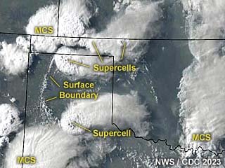
Above: This an annotated visible satellite image at roughly 0z (evening) on May 28, 2023 showing the synoptic environment. Supercell storms are occurring over the Texas and Oklahoma Panhandles. Note the distinct surface boundary pushing slowly west as well. Upper air support for storms was negligable.
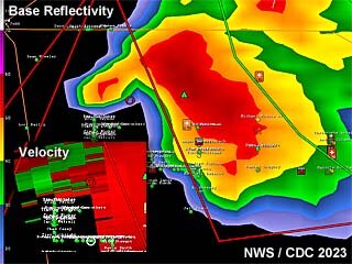
Above: This is a radar image (base reflectivity) of a powerful tornadic supercell storm southeast of Stratford, Texas at roughly 7 PM CDT. This is when the storm was producing tornadoes, with a highly unusual (deviant left-split) motion to the northwest. The velocity is in the lower-left inset.
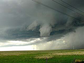
Above: Funnel cloud rotating on the rear-flank / southern side of the Beaver County, Oklahoma supercell. The view is to the northwest.
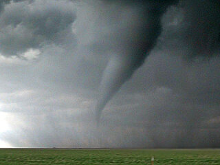
Above: Beautiful tornado southeast of Stratford, Texas. The view is to the west and northwest.
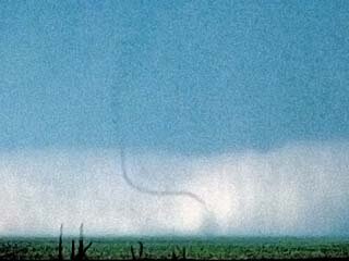
Above: Another rope tornado southeast of Stratford. The view is to the west.
Summary: May 28 was a seemingly marginal chase day with low expectations, however, turned out to be an extremely busy and productive day, with supercells and at least 4 tornadoes observed in the Texas / Oklahoma Panhandles! I looked at data in the morning and saw a marginal chance of supercells, with the best chances of storms near a general area in triangle from Stratford, Texas to Perryton and Guymon, Oklahoma. Winds aloft were quite light (6km bulk shear of 25 knots max), so low level dynamics and terrain were the main influences of the setup. The SPC also had this area in a slight risk, with 5% wind and 15% hail probabilities. Tornado probability was near zero (less than 2%). I headed north on Highway 287 out of Amarillo during the late morning, stopping in Dumas for lunch, then east on SR 152 to Stinnett, then northeast on SR 207 to Perryton, taking Highway 83 north out of there. A supercell was encountered early in the afternoon near Turpin and Balko in Beaver County. This storm produced large hail and funnel clods before weakening during the late afternoon. I left the storm, targeting another supercell back southwest, heading back down via NS 130 road off Highway 412 to SR 207 in Texas to head southwest. The SPC also had mesoscale discussion 890 in effect. No watch was issued. I headed down SR 207 to Spearman, then west on FM 520 / 1573 (large hail was encountered in FM 520 as the right-split dissipated there), eventually targeting a powerful left-split supercell, that moved to the northwest (extremely deviant motion), and produced significant tornadoes in Sherman County southeast of Stratford, Texas and FM 119. I wrapped up this great chase day at sunset, heading west to Highway 287, punching through an MCS that overtook the supercell storm, and fueled up in Stratford. From there, I took Highway 54 northeastward across Oklahoma, through Guymon, and into Liberal, Kansas for the night. What a day.
Full online chase log for 2023 (including this one) can be found here: www.sky-chaser.com/mwcl2023.htm
Details (on May 28)...
1). May 28, 3:00 PM - Interception and indirect penetration of a very severe and possibly tornadic thunderstorm in Beaver County, Oklahoma, north of Highway 412 and east of Highway 83 near Turpin and Balko. The storm was a classic supercell storm. A strong area of rotation was noted on the rear-flank of the storm, with rapidly rotating wall clouds, and funnels observed. The storm core was not directly penetrated, but hail to 1", 60 MPH winds, occasional lightning, and moderate to heavy rain was encountered near the core of the storm southeast of Turpin. The storm evolved to HP and weakened via down-scaling after that. Conditions causing the storms were surface heating, a weak low pressure trough, boundary interactions, and a negligible upper trough. Documentation was digital stills and HD video (with time-lapse). A 2022 Jeep Renegade was used to chase the storm.
2). May 28, 7:00 PM - Interception and observation of an extremely severe and tornadic thunderstorm in Sherman County, Texas, southeast of Stratford and near FM 1573 and 119. The storm was a classic to HP cyclic supercell storm. One interesting aspect of this storm was that it was a left-split, with the right-split completely dissipating. This highly deviant left-split moved to the northwest, and produced multiple (at least 4) tornadoes, one a large stove-pipe / elephant trunk, another a rope, and even multi-vortex. This storm had a very impressive visual appearance as well, with incredible inflow / rotor feeding into it (stream-wise vorticity current), RFD cut, and striated "multi-tiered" updraft. The storm core was not penetrated, but isolated 1" hail was noted falling out of the storm anvil south of the storm. Larger hail from the right-split was observed along the side of the road, from golf-ball sized to 2". Other conditions observed were 60 MPH inflow winds and frequent lightning. The storm merged with a powerful MCS, which had 60 to 70 MPH winds, torrential rains, and marble sized hail southeast of Statford along Highway 287. No major damage was observed, as these storms occurred over rural areas. Conditions causing the storms were surface heating, a weak low pressure trough, boundary interactions, and a negligible upper trough. Documentation was digital stills and HD video (with time-lapse). A 2022 Jeep Renegade was used to chase the storm.

Above: This an annotated visible satellite image at roughly 0z (evening) on May 28, 2023 showing the synoptic environment. Supercell storms are occurring over the Texas and Oklahoma Panhandles. Note the distinct surface boundary pushing slowly west as well. Upper air support for storms was negligable.

Above: This is a radar image (base reflectivity) of a powerful tornadic supercell storm southeast of Stratford, Texas at roughly 7 PM CDT. This is when the storm was producing tornadoes, with a highly unusual (deviant left-split) motion to the northwest. The velocity is in the lower-left inset.

Above: Funnel cloud rotating on the rear-flank / southern side of the Beaver County, Oklahoma supercell. The view is to the northwest.

Above: Beautiful tornado southeast of Stratford, Texas. The view is to the west and northwest.

Above: Another rope tornado southeast of Stratford. The view is to the west.
