Who woke up thinking today was going to be like this, raise your hands... just what I thought...
Okay, to be fair, massive CAPE and near 70s dews at 3000' with a nearly stationary boundary in play. I suppose one could argue that you figured the potential would be there. But I don't think any of us ending the day thought it would go down quite like this.
I departed my northern Colorado home mid-afternoon on Wednesday to make the short, four hour drive to Lamar, Colorado. I had two targets in mind; the southern TX Panhandle and the southeast CO/southwest KS area. I deliberately made left the day before to allow me the opportunity to keep that southern play in mind. I got to Lamar with a minor detour to look at some landspout potential storms southeast of Denver, but they ultimately did nothing and simply delayed my Lamar arrival by 90 minutes.
I woke up about 8am in Lamar and gave everything a look. I was still somewhat undecided, definitely leaning toward the longer drive south, but a couple things kept me honest. First, I KNEW the southern target was going to be a chaser-fest... I had absolutely no doubt in my mind it was going to be nuts down there. The northern play was easily the secondary target, road-friendly, and was going to keep me largely in the area I assumed would be the target the following day. Secondly, it was an easier, shorter (lazier) drive to the northern target. Hell, I was practically already there; could've had a super chill morning. And that idea worked to a 'T' on May 18 when the 'less chaser crowd' secondary target (also in western Kansas) paid off immensely.
But that was the reason I made the drive the night before... and I was going to stick with it. BUT... I didn't want to completely blow off the area. So I opted to give myself til Boise City to make the final call. I figured I can make a body break stop there, take a final look, and pull the trigger either way. If I decided to stay with the northern play, I had an easy, short backtrack. If I decided southern, I was enroute with a 3pm arrival to Lubbock. I got to Boise City Love's and had a 15 minute stop and made the final call. GO SOUTH...
So the rest of the drive commenced... nothing crazy. I had a couple early afternoon live hits to account for (3pm and 4pm); hoping to make north side of Lubbock by 3pm CT so I could gas up, food up, bladder break, and do my hit all in one stop. Unfortunately I was about 15 minutes slower, stopping in New Deal for the first hit and food, then mowing through that food to get to the Love's on the north side of Lubbock where I took care of the vehicle setup and windshield cleaning and fueling up. With about 20 minutes left til the second hit, I decided to hold there and do that second hit. Meanwhile, as is customary for me, I bought a scratch ticket (I try to do so before every chase)... typically when I win on the scratcher, I bust on the chase. So needless to say, I was busting for sure...

I cashed that in, did my second hit from the truck stop, and immediately west I went out of Lubbock via TX-114. The supercells (two of them) had already gone up and were severe by Causey at this point. I knew I was running a bit behind, but I had no panic in me, even as the storm began to produce tornadoes as it approached the border. I recall thinking to myself as I approached that this was only the beginning, and to sit tight, you'll there.
Morton was my intercept point, and I did a drive live hit at 5pm approaching the town. That hit over with, I got west of Morton and while distant, was already adding tickmarks to the count as I saw the end of one tornado and a brief second tornado on my approach.

At this point, I was introduced to the chaser congo line... As much as I wanted to be pointed AT the approaching storm, I forced myself on the eastbound facing shoulder to allow me quicker access back onto the road as I would wait literal minutes for an opening in the endless line of cars coming east. After a couple stops, and TX-114 turning slightly southeast away from the currently eastward-moving storm, I knew it was time to find a new road.
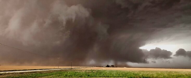
While eastbound, the new meso took over, basically putting me due south of the new area. I had a camera pointed north out of my window as I was soloing the congo line, ensuring I was driving safe as opposed to trying to stare at the storm. I had no desire to be the bad guy and rear-end someone. Fortunately, while insanely packed, I ran into ZERO issues at this point; everyone well-behaved and not having to worry too much. Meanwhile, the new circulation was overtaking the entire sky, and it was becoming clear that a monster was looming.

My plan was to get on CR-109 to eastbound CR-64. But I screwed up and turned on the road before that one, CR-105. I quickly realized my mistake, cursed myself ever so slightly because the road was too narrow to make a quick U-turn, but alas, I had an unimpeded view of the incredible tornado to my north, so quickly scanning for eastbound options, I opted to go ahead and stick with this choice, being about 2 miles further north than intended as there was a good stretch of eastbound road, and despite the dirt, was in solid enough condition to stick with.

Somewhere just north of CR-44, I flipped around when my east view was blocked by wind-breaker trees, got back to a pull out with a clean view to the east and sat, snapping away at the wedge as it was beautifully lit, filling my entire point of view. The dusty wedge beneath the bright white clouds, everything spinning as one unit. A satellite, which I didn't even realize at the time, developed and fully condensed. I decided because the structure was so insane to go 14mm on my Nikon and snap away.
This was a bucketlist tornado. I knew it in the moment; I set the video cameras to run on their own so I could ensure I got the photos I wanted out of this. The shot above, again, me completely unaware, includes the fully condensed satellite tornado on the left side of the tornado.

I stuck around here for a few minutes, and got a little antsy as I wanted to keep up with the storm, so I probably took off a little earlier than I absolutely needed to, sacrificing a minute or so more of viewing as the tornado was beginning to disappear to my east within the rain and dust. I jumped east on CR-44 (I think) over to TX-214, then back east on FM-597.
It was on the eastbound approach where I got a view of the tornado again, still a wedge. Now I've recently had a string of thinking I was observing the same tornado much later, but I have also heard this may have been a new tornado? As of now, I will keep the assumption it was the same one and let the damage survey decide.

I didn't have this view long as the roads were becoming a little more questionable. My goal was to hit US-385 and decide from there what to do next. By this point, the hook was starting to extend south and I did not want to get taken over by intense precip and hail, particularly on the dirt roads. I decided I would get back south to TX-114 via Country Road out of Whitharral. Racing south to beat the hook, I got smothered in the strong RFD, but fortunately made it south to pavement with no issues.
At this point, it was now all about Lubbock. When I got to TX-114, it was packed as you can imagine. I for some odd reason, thought the storm was moving slightly faster than it was (and I probably had bad perception of exactly how far from Lubbock I was), so I actually was like, lets get on the east side of the city and watching as it approaches from there. When I got to the TX-289 Loop, originally I was going to go north, but there was an ever-so-slightly southerly vector to the storm, so I decided on the southern part of the loop instead. I was listening to live broadcasts as another tornado was reported, and when the location (Smyer) was mentioned, I knew I was getting way too antsy, so I flipped back around and retraced my steps, taking TX-114 back west of town. I had an incredible wide view of the approaching supercell as I was westbound on the loop.

I set up near Reese Center, catching a view up into the notch of a large tornado to my northwest. I proceeded north for a better look and had two tornadoes on the ground at the same time.

I didn't get great imagery where as the contrast was low, it was getting closer to sunset, and rain and dust were just a constant between me and the tornadoes. I backed out of this area, crossed TX-114, and headed south. By this point, the storm looked like it was transitioning to an outflow dominate mode. A large hail core and intense winds were of great concern, and I did not want to get stuck in Lubbock traffic should something really bad start happening. With no view into the tornadic area of the storm and a HUEG mix of locals and chasers around, I decided it was time to flee.
My objective at this point was to get on the south side of the expanding hook/RFD region, then cut west over to US-62 near Wolfforth, and circle in behind the storm. I cleared the south edge of the hook, turned west, then did exactly that, arriving into Lubbock right behind the storm to see tons of flash flooding all across the city.

After documenting the flooding, I got back over to I-27 and rolled up to Plainview for the night. After I got settled, had a very late iHop dinner, I reclused into my hotel for editing and to get some shuteye, only to be rudely sent outside in my PJs when a severe storm was making its way in. It was warned for tennisballs and 60mph winds; fortunately did not have the tennisballs, but did have the winds. For about 20 minutes, it reminded me of a hurricane, and during that Cat-1 cane, the ceiling in my hotel room began leaking, and I was moved to the jacuzzi suite to sleep a few hours ahead of what will likely be a round 2 in the same area.
I don't care at all that a million people got the same shots... oddly enough in the peak moments of the Morton intercept, I felt pretty much all by myself; only a few chaser vehicles in my visual vicinity. Taking the off-roads paid off well, and allowed me the opportunity to capture a handful of images I have waited an entire career to get. This was truly a bucketlist tornado for me, and I was so happy in the moment and very deliberate in making sure I got the shots I wanted. More so thankful this monster did NOT go into Lubbock. They should be waking up today just so grateful that the worst did not happen in their city.
This was a day for the ages; and when combined with the incredible stretch in May, is running 2025 further up the list of my best chasing season, so certainly one of the highest for quality-tornado intercepts. It's gonna give 2023 a run for its money, and after it soaks in a bit (after the next couple days try to add to it), it may have consideration for the #1 spot.