Jason N
EF5
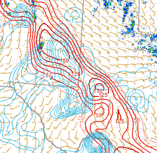
Those of you who are stuck with your trip days and are playing SW TX tomorrow... good luck, I'm getting the feeling it will be a lot of post sunset convection with the timing of the mid-level Vort/shrtwv and surface low kick out. left over cloud debris, cooler temps as well.. but forcing should prevail over time (but what time has been a matter of question) it's lower end risk overall but there could be spots closer to the surface low that might bring the best potential.
From what I saw this evening, subject to change of course tomorrow, the models do bring in some showers and clouds further east from San Antonio to Abilene cutting off or possibly limiting some boundary layer moisture feed and lapse rate support the further east you go, so the area will remain tight geographically.
I saw Snyder or Brownfield or LaMesa as a potential staging area and a possible real boom/bust further south around Ft. Stockton, which you could set up in McCamey, Rankin or Big Lake, to get the best North run to Midland if it doesn't pan out, but that's a crap shoot depending on what model handles things tomorrow the best. Winds are backed better further north, but the air seems cleaner the further south from Odessa to Ft. Stockton and below you go.. but on the Skew-T's there's a decent Cap, and terrain issues increase to so, again.. boom bust.. hopefully the CAMS and Meso-analysis feels this out tomorrow during the day, the skies clear an the SFC temps go up a bit.
good luck everyone.