• After witnessing the continued decrease of involvement in the SpotterNetwork staff in serving SN members with troubleshooting issues recently, I have unilaterally decided to terminate the relationship between SpotterNetwork's support and Stormtrack. I have witnessed multiple users unable to receive support weeks after initiating help threads on the forum. I find this lack of response from SpotterNetwork officials disappointing and a failure to hold up their end of the agreement that was made years ago, before I took over management of this site. In my opinion, having Stormtrack users sit and wait for so long to receive help on SpotterNetwork issues on the Stormtrack forums reflects poorly not only on SpotterNetwork, but on Stormtrack and (by association) me as well. Since the issue has not been satisfactorily addressed, I no longer wish for the Stormtrack forum to be associated with SpotterNetwork.

    I apologize to those who continue to have issues with the service and continue to see their issues left unaddressed. Please understand that the connection between ST and SN was put in place long before I had any say over it. But now that I am the "captain of this ship," it is within my right (nay, duty) to make adjustments as I see necessary. Ending this relationship is such an adjustment.

    For those who continue to need help, I recommend navigating a web browswer to SpotterNetwork's About page, and seeking the individuals listed on that page for all further inquiries about SpotterNetwork.

    From this moment forward, the SpotterNetwork sub-forum has been hidden/deleted and there will be no assurance that any SpotterNetwork issues brought up in any of Stormtrack's other sub-forums will be addressed. Do not rely on Stormtrack for help with SpotterNetwork issues.

    Sincerely, Jeff D.

2025-03-15 EVENT: AL/MS/AL/FL/GA/TN

Warren Faidley

Supporter
Joined
May 7, 2006
Messages
2,593
Location
Mos Isley Space Port
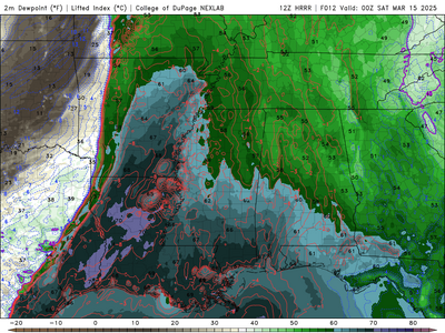
Social media is going bonkers over Saturday's (3-15-25) set-up.

Lot's of PDS and TOR soundings in the region. Some 0-3km SRH's in the 400-800 range with CAPEs in the 2k -3k range. There is a fail mode if convection late Friday and/or Saturday AM mucks up the warm sector on Saturday. Big fire risks on Friday in Texas, regardless of what happens to the east.

Storm movement at 50+kts should make chasing fun in the trees.

Lot's more to come when additional models kick-in tomorrow.
 
Last edited:
Saturday could be a North Alabama chase day, or MCS rainout. Euro shows a distinct possibility of the latter. Euro is also the one with the most backed 850/925 mb. What giveth can taketh away - or MCS away.

GFS has greater instability and plenty of turning with height. Morning breaks of sun are why it gets more unstable. NAM seems to split the difference, if anyone really cares about the 84 hr. NAM. Canadian also has the morning break in the action.

Yeah one does not chase anything on Saturday. The only workable and safe strategy is to get ahead and wait. Chance of following anything for a significant distance is low.

Flatter fewer trees Agricultural part of the Tennessee Valley in North Alabama would be a convenient place for an outflow boundary. Alas surface details are TBD pending Friday night precip.
 
Dewpoints Saturday at least look better than Friday, so maybe not a total waste of a strong, negative-tilt mid-March upper level trough? The barely in-range CAMs seem a bit more bullish on moisture return than the global models. I'm still seeing minimal capping during the day Saturday with storm motions approximately parallel to the forcing gradient, so I would anticipate a messy mode or at least limited window for discrete mode.

It seems the predecessor event shunting moisture back into the Gulf is fortunate for the millions living in the area, though less fortunate for the small subset that visit this forum.

My gut says there will be a TEC in a narrow but relatively pristine area of the warm sector, but it will likely be in the forests and moving fast.
 
18z models suggest a morning speed max breaking out storms in the northern half of the deeper moisture plume through noon. That's the only big potential negative. Despite the departing speed max, the rest of the warm sector remains prime. As already mentioned, if the morning activity is less robust, the spatial extent of the high-end environment will be maximized. Plenty of high-end/extreme analogs for this system, including 4/27/2011.

Without a drone, I'm not sure I would attempt this one. A drone lets you get a perfect view anywhere (given clear airspace). The caveat is that the ambient surface+inflow winds in this environment will be a challenge for smaller drones to hold a stable position.
 
Last edited:
Image.jpg
When I looked at the mid-level heights last night for Saturday evening on the GFS,
I was reminded of the impressive horizontal extent of this trough across the US.
I'm trying to think back to when I've seen something so all-encompassing.
These huge waves are associated with significant, severe outbreaks.
 
Last edited:
Back
Top