-
While Stormtrack has discontinued its hosting of SpotterNetwork support on the forums, keep in mind that support for SpotterNetwork issues is available by emailing [email protected].
You are using an out of date browser. It may not display this or other websites correctly.
You should upgrade or use an alternative browser.
You should upgrade or use an alternative browser.
2025-03-15 EVENT: AL/MS/AL/FL/GA/TN
- Thread starter Warren Faidley
- Start date
Jason N
EF5
Warren Faidley
Supporter
Will be interesting to see if things become more "high risk / long track" once the evening LLJ kicks in. Really a messy-mode type day with too much forcing and maybe not enough cap? All the damage I've seen so far looks low ended, which is a very good thing.
Dan Robinson
EF5
I woke up at 5am this morning in preparation to head down there, but just looking at the radar even that early it was apparent it wouldn't be worth that 8 hour haul. I can't say I was sure it was going to bust like this (from a chaseability standpoint), but with the prospect of that long of a drive through that much precip after a short night's sleep, I didn't need much dissuading influence.
JamesCaruso
Staff member
High Risk days so often disappoint from a chasing perspective. Any day with such strong dynamics makes it likely storms are going to go up all over the place, posing issues for storm mode, interference and visibility. The strong 500mb winds that are a key feature of such outbreaks also means 50-60 mph storm motions. Add in the terrain issues in MS/AL and it’s hard to justify a chase trip. The ceiling on such events is by definition already high, meaning there is generally more downside than upside. It’s like in my finance role, if I forecast best-case scenario profits I know we can only underperform.
Having said that, I still regret not chasing Iowa May 24 2024 because of pessimistic expectations like this (of course, driving distance before and after the “big day”, and the related cost/benefit analysis, also enter the decision-making on days like that…) On days like yesterday, there is some sense of drama and excitement just being near the action, even if the visuals are underwhelming and you’re flittering around impenetrable HP storms like moths around a flame.
Having said that, I still regret not chasing Iowa May 24 2024 because of pessimistic expectations like this (of course, driving distance before and after the “big day”, and the related cost/benefit analysis, also enter the decision-making on days like that…) On days like yesterday, there is some sense of drama and excitement just being near the action, even if the visuals are underwhelming and you’re flittering around impenetrable HP storms like moths around a flame.
Sean Ramsey
EF5
Chaseability in the southeast is why I most always forego these events, but I always have a bit of pessimism when it comes to Dixie Alley chases because the available moisture almost always seems to produce rainy messes, with notable exceptions. The potential is always there, but it's rare that it's actually realized.
As far as chaseability, these set ups are usually good for streamers/media chasers simply by being there, or those with drones, who have the best chance of seeing anything out of anyone, but only with perfect conditions. I've always struggled with driving 10+ hours one-way to see a tornado for at best 5 seconds (I don't own a drone) between trees, with a 95% chance of driving in blinding rain at least half the time. The chances of capturing a quality still image may be less than 1%.
Logic and sensibility are sometimes at odds with being a good and/or relevant chaser and I have too much of the former (probably to my detriment) to be anything close to the latter.
Warren Faidley
Supporter
Never had a burning desire to chase Dixie Alley mega-days unless the perfect set-up occurred, which is generally not known until the AM of the event day. This forecast never quite had that "oh-shit" factor for me. Deciding to chase by tightly-spaced helicity track forecasts is not my thing. Give me a 30% chance of a cap bust and I'll take a chance. A lot of social media chasers were noting failure modes with EML and storm mode until the High Risk was issued. Forecasting a High Risk is not the same as forecasting a good chase day, especially this early in the season. As others have noted, devoting the time and expense to see a ground hugging, vaporous wedge is not really worth it.
Brett Roberts
EF5
I have to say after two decades of chasing, and therefore usually enduring peak SDS-fueled temptation during Dixie's climo max in March-April: to this day, the only event I actually wish I'd gone out there for is 27 April 2011. This is especially true if I only consider "obvious" high-end setups with, say, a >=MDT risk and PDS watches (of which that region gets plenty, and more reliably year-to-year than the Plains).
As someone who's usually an armchair Dixie observer, it's curious how often "it's the insolation, stupid" has started rattling around in my head as a pretty good discriminator of widespread, high-end, visible tornadoes. Everyone knows and accepts that thermodynamics are critical and non-negotiable in the Plains. I think where people can get into trouble is that Dixie often has extreme low-level wind shear that can spin up strong tornadoes even in thermodynamically and therefore visually awful environments, e.g. the stuff around Birmingham yesterday evening... and a bunch of those spin-ups can verify high-end outlooks and watches. But for chaseability, that is such a far cry from a prolific, classic supercell outbreak like 27 April 2011.
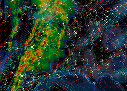
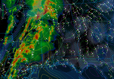
It's easy to get on the hype train and envision something like a "poor man's 27 April 2011" leading up to an event like yesterday's. And, to be fair, that couldn't be ruled out a couple days in advance... even though global models and ensembles showed a consistent signal for widespread precip and very limited CAPE by 21z-00z. By yesterday morning at 10am, IMO, visible satellite all but ruled out the "poor man's 27 April" scenario... and people like Dan made the correct decision.
I think one key difference between the median Plains hype day vs. the median Dixie hype day is that if the Plains setup starts unraveling, it usually unravels hard... to the point it's really obvious that expectations won't be met and it may not be worth chasing from long distance. Whereas in Dixie, it's common for setups to shift from the "maybe this is the once in 5 years classic supercell outbreak where I can see Tuscaloosa Pt. 2" category to the "HP grunge near the Gulf and a bunch of embedded spinups north of that" category without any loss of hype, since the latter is still dangerous to the public. Which makes it extra important to evaluate chaseability as a completely independent factor from official forecasts or UH tracks... even if your standard for chaseability is pretty low. (Unless your motivation for chasing is basically just to position yourself under the brightest possible national spotlight where you can stream pine trees and pick up more followers, but that's for another thread).
William Monfredo
EF4
The uptick in chasing the Southeast appeared April 1999, Easter, IMO. That truly surprised me, because I lived in Mississippi for three years and Louisiana for four, and chasing can be particularly frustrating & dangerous in those states due to all the HP cells, haze, or trees as mentioned....is still dangerous to the public.
Yesterday afternoon, a veritable "squadron" of supercells presented much danger to the people of southern MS. Numerous PDS tornado warnings kept people in Bassfield and Taylorsville from venturing too far. Tornadoes hit the Tylertown area twice for example, killing three people.
Oops, I sound like the news...
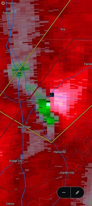
Below shows purple-blue correlation coefficient at 12:38 p.m. CST from Hammond, LA (KHDC) when Tylertown, MS was under the gun.
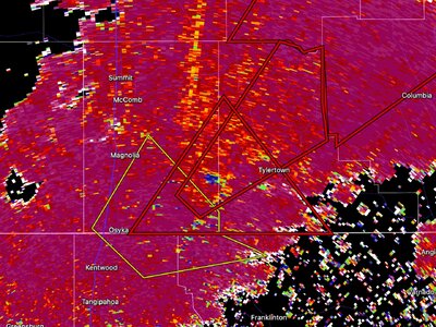
What's good about the trees? They act as "fuel" for the correlation coefficient w/ all the air-borne leaves/branches when a tornado occurs.
Last edited:
Randy Zipser
EF4
This "Big March Outbreak" has just passed through my area of the Gulf Coast of FL, and is pretty much over without so much as a whimper...a dud is more like it. The hype about the existing tornado watches and occasional quick spin-ups along the coast in counties to my south is still being spouted by local media, but does not match the "break-in-overcast, occasional light-rain" reality, at least here.
During the very active and prolonged tornado season in 2024, related to a waning, but still noticeable, ENSO pattern over Florida, the tornado events were very obvious but seemed to be much less messy than this one and had a whole different "feel" to the way the events unfolded. Last year, many of these events were nocturnal or in early morning hours, not so much dependent on daytime heating and/or arrival of frontal boundaries associated with strong, dynamic mid-latitude systems.
It will be interesting to see how the Dixie Alley season transitions to Tornado Alley in the next few weeks with the neutral ENSO pattern in place now. The bullseye may be further SE than usual if the annual trend toward the Lower Mississippi Valley continues, except, of course, for TX Panhandle dryline setups.
Randy Zipser
EF4
This thing is not quite ready to give up yet in west-central FL. Earlier this evening a confirmed waterspout came ashore in extreme SE Hillsborough County near the Manatee County line [not far from the Ruskin NWS (TBW)]. Within the past 45 minutes, local TV showed a cell with a pronounced appendage and strong radar-indicated shear velocity to the SE of Zephyrhills, FL, in the NE corner of Hillsborough County, moving NE at 25mph. This is over a swampy area with few inhabitants, so likely no funnel was observed. The point being: despite being ahead of a weakening front in a modified air mass with no surface heating and removed from upper-level support, storms will still rotate enough to cause waterspouts and/or weak tornadoes over the Florida peninsula following the previous day's Dixie outbreak.
Jason N
EF5
I generally will not chase dixie period (for me specifically). After 2011, I have that upper/mid level wind/jet orientation from that day burned into memory, it is key to the expected moisture returns at the surface. The cross over orientation of the 200 to 500 winds, despite all of the strong kinematics/shear I felt was too SWrly when it should have been a little more Wrly, so it was going to be messy modes and probably underperform (a good thing as it turned out), and it was pretty apparent in the cloud/radar presentation in the morning all the way through 1pm. the points about the EML were also clutch I think as well.
I've mentioned this before in previous threads about the chase dynamics in how I rationalize the "go vs. no-go" and it comes down to a few simple things for me:
- Regardless of model forecasts, what does that days environment look like. (all aspect meso-analysis data.)
- The nature of the geography / roadways / escape routing / visibility / population density. (the SE is just not inherently built for safe chasing when storm motions exceed 40-50kts.)
- Storm motion forecasts, anything over 40kts and I am adjusting how I chase it, (depending on where I am in the country) anything over 50kts.. stay down stream and wait.. cause I am only doing this once or not chasing at all. it's not worth it.
- I do not chase QLCS or segments, it's boring. I've chased after a few embedded MCV's and caught a few spin ups but its draining when coupled with navigating and being safe. cockpit management is important when you are also managing risk.
is it restricting me to void out areas of the country that do possess regional outbreak/chase possibilities? yes. but it's worth it in my opinion for most setups barring a 2011, which this was not.
Last edited:
William Monfredo
EF4
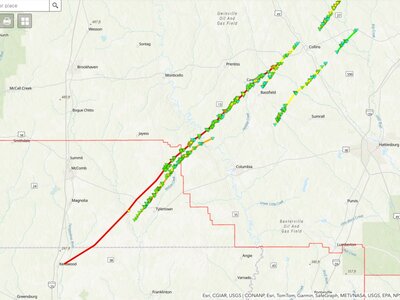
Damage Assessment Toolkit shows the location of a third EF-4, stretching from extreme northern LA into Southern, MS near Bassfield.
The long-tracked storm produced estimated winds up to 170 mph & travelled on ground for over 65 miles on Saturday afternoon.
My previous posts of radar in this thread show the remotely-sensed images from this deadly storm, 12:38 & 12:41 p.m. CST.
No small potatoes, this tornado killed 5 people, injured almost 30 individuals, and churned along for well over an hour.
Last edited:
Jason N
EF5
I watched an interesting YouTube video, forget the channel name, but the person was talking about how EF5's may be gone forever because of the nature of how damage reporting has taken over as opposed to wind speed velocities measured from radar, and thats why El Reno was dropped to EF3 status even though it was clearly EF5 winds being measured.. I think it's worth a real good debate in my mind, but may have been addressed elsewhere hereView attachment 26877
Damage Assessment Toolkit shows location of a third EF-4, deadly, stretching from extreme northern LA into Southern, MS near Bassfield.
William Monfredo
EF4
Rating by damage remains the status quo, but amazing to think how few human-constructed damage-indicators exist in Mississippi....EF-5s...nature of how damage reporting...
In fact, the total population of MS amounts to less than two Philadelphia, PAs, even though MS measures ~ 341 times larger in area.
In other words, who knows what goes on with respect to intensity in an outbreak like this? But, radar images certainly provided hints.
Similar threads
- Replies
- 7
- Views
- 2K

