• After witnessing the continued decrease of involvement in the SpotterNetwork staff in serving SN members with troubleshooting issues recently, I have unilaterally decided to terminate the relationship between SpotterNetwork's support and Stormtrack. I have witnessed multiple users unable to receive support weeks after initiating help threads on the forum. I find this lack of response from SpotterNetwork officials disappointing and a failure to hold up their end of the agreement that was made years ago, before I took over management of this site. In my opinion, having Stormtrack users sit and wait for so long to receive help on SpotterNetwork issues on the Stormtrack forums reflects poorly not only on SpotterNetwork, but on Stormtrack and (by association) me as well. Since the issue has not been satisfactorily addressed, I no longer wish for the Stormtrack forum to be associated with SpotterNetwork.

    I apologize to those who continue to have issues with the service and continue to see their issues left unaddressed. Please understand that the connection between ST and SN was put in place long before I had any say over it. But now that I am the "captain of this ship," it is within my right (nay, duty) to make adjustments as I see necessary. Ending this relationship is such an adjustment.

    For those who continue to need help, I recommend navigating a web browswer to SpotterNetwork's About page, and seeking the individuals listed on that page for all further inquiries about SpotterNetwork.

    From this moment forward, the SpotterNetwork sub-forum has been hidden/deleted and there will be no assurance that any SpotterNetwork issues brought up in any of Stormtrack's other sub-forums will be addressed. Do not rely on Stormtrack for help with SpotterNetwork issues.

    Sincerely, Jeff D.

2025-03-15 EVENT: AL/MS/AL/FL/GA/TN

Warren Faidley

Supporter
Joined
May 7, 2006
Messages
2,610
Location
Mos Isley Space Port
Social media is going bonkers over Saturday's (3-15-25) set-up.

Lot's of PDS and TOR soundings in the region. Some 0-3km SRH's in the 400-800 range with CAPEs in the 2k -3k range. There is a fail mode if convection late Friday and/or Saturday AM mucks up the warm sector on Saturday. Big fire risks on Friday in Texas, regardless of what happens to the east.

Storm movement at 50+kts should make chasing fun in the trees.

Lot's more to come when additional models kick-in tomorrow.
 
Last edited:
Saturday could be a North Alabama chase day, or MCS rainout. Euro shows a distinct possibility of the latter. Euro is also the one with the most backed 850/925 mb. What giveth can taketh away - or MCS away.

GFS has greater instability and plenty of turning with height. Morning breaks of sun are why it gets more unstable. NAM seems to split the difference, if anyone really cares about the 84 hr. NAM. Canadian also has the morning break in the action.

Yeah one does not chase anything on Saturday. The only workable and safe strategy is to get ahead and wait. Chance of following anything for a significant distance is low.

Flatter fewer trees Agricultural part of the Tennessee Valley in North Alabama would be a convenient place for an outflow boundary. Alas surface details are TBD pending Friday night precip.
 
Dewpoints Saturday at least look better than Friday, so maybe not a total waste of a strong, negative-tilt mid-March upper level trough? The barely in-range CAMs seem a bit more bullish on moisture return than the global models. I'm still seeing minimal capping during the day Saturday with storm motions approximately parallel to the forcing gradient, so I would anticipate a messy mode or at least limited window for discrete mode.

It seems the predecessor event shunting moisture back into the Gulf is fortunate for the millions living in the area, though less fortunate for the small subset that visit this forum.

My gut says there will be a TEC in a narrow but relatively pristine area of the warm sector, but it will likely be in the forests and moving fast.
 
18z models suggest a morning speed max breaking out storms in the northern half of the deeper moisture plume through noon. That's the only big potential negative. Despite the departing speed max, the rest of the warm sector remains prime. As already mentioned, if the morning activity is less robust, the spatial extent of the high-end environment will be maximized. Plenty of high-end/extreme analogs for this system, including 4/27/2011.

Without a drone, I'm not sure I would attempt this one. A drone lets you get a perfect view anywhere (given clear airspace). The caveat is that the ambient surface+inflow winds in this environment will be a challenge for smaller drones to hold a stable position.
 
Last edited:
...fun in the trees.
When I lived in Mississippi, I tried not to chase much there because of all the pine trees once you get away from the Delta.
But since we've got great speed & directional shear with such good difluence & instability forecast for Saturday, I can certainly see the appeal.
On the plus side, a lot of the rain and hail will therefore blow downstream and won't affect visibility as much if you play your positioning right.
Just beware for the trees falling across the roads which means driving a bit slower. Since I won't be there, get some good video and photos. :D
 
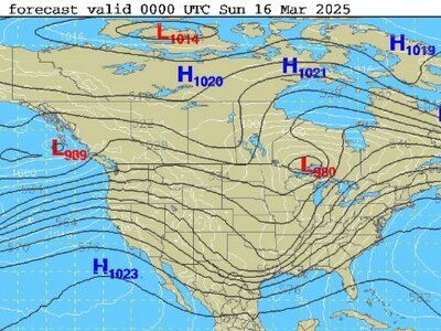
One thing I noticed about this set up as to what happens large-scale
does not happen very often. Right behind the main trough that
spawns the Midwest strong sfc low today, another sig trough comes in,
which results in another sfc low developing, but not nearly intense
as the Midwest low. However, the overall setup in terms of the
jet config and low-level moisture availability appears much better than
today, and this may lead to a high-end tornado outbreak

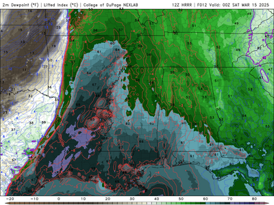
It has been noted that in virtually all of the biggest tornado outbreaks
-- deep low-level moisture is already in place 24 hr *before* the event,
and this true for at least part of the MDT risk area (see HRRR dew point
forecast 15/00z. Today's sfc low puts that moisture in place across the
South, then the second sfc low on Sat basically has a field day tapping this
moisture for a lot of CAPE combined w/ excellent jet dynamics, leading
to a high risk of a major tor outbreak.
 

Attachments

  • dp.png
    dp.png
    484.4 KB · Views: 4
Screenshot 2025-03-15 at 9.09.49 AM.jpg
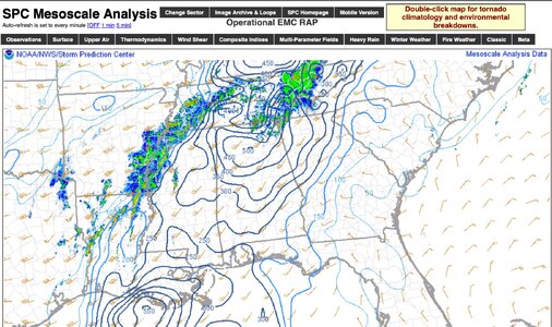
These 0-1 km Storm Relative Helicity values at 9 a.m. CST are 300-500 m2s2 in some areas of eastern MS and much of AL.
Wow, that's really high. All things considered, thunderstorms that form will rotate and produce tornadoes for chasers today.
 
The fact we have such widespread coverage of storms so early may preclude this event from being absolute high-end tornado event (numerous long-tracked, strong/violent tornadoes), but instead numerous weak tornadoes, such as what happened in this same area on Dec 28-29, 2024 (109 tornadoes, but only 3 EF2s and 3 EF3s)..

But we will have to see the extent of discrete cells that will/may fire later ahead of the squall line. One thing that is apparent with tornado outbreak days, it is often a fine line between a day with numerous weak tornadoes and many long-tracked, strong/violent tornadoes, and sometimes it is not apparent until it actually is happening!
 
As I noted earlier in this thread, lack of EML and storm motions close to parallel to the forcing are leading to downstream crapvection and messy storm mode overall. It feels like most of MS is essentially out of play for any high end outbreak. However, last night we saw fast storm motions outrun some of the storm interference and discrete mode emerged from a more QLCS beginning. I am still expecting soem of this to occur in AL later this afternoon and still my gut says there could be a long-track TEC on the southern periphery. The storms currently near Jackson, MS and near the MS/LA border appear to have potential to evolve into this over time.
 
Agreed that this does not have the look of a good chase day at the moment. High-end tornado threat for sure, but in mostly messy HP blobs with too much convection going up. Things may improve later, but I can't think of many days that looked this HP early and ended up more classic.
 
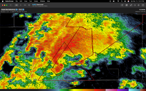
Southern MS supercell, a tornado-producer, w/ debris (indicated by correlation coefficient...)
Screenshot 2025-03-15 at 12.41.14 PM.png
Later edit...from MCD 204 at 12:51 p.m. CDT:
Data out of KHDC shows...radar derived rotation of 60+ knots (briefly over 90 knots) and a tornado debris signature over 25kft.
This suggests an intense to violent tornado. This storm is located in the centroid of the maximum STP of 6-8 from SPC Mesoanalysis.
 
Last edited:
I was asked to post this into todays room , I posted it in yesterdays lol.. oops.. and it appears my line of thought below isn't uncommon:

So no one is going to discount the intense amount of dynamics available today to produce some intense vortex generation and potentially long track cell potential however..... I for one, am going to say that despite this potential, I wonder if today might actually under perform a bit ?? (which would be a good thing!) at least in terms of discrete activity?

based on current satellite/radar presentation of excessive convective cloud debris at 1pm with no real large areas of clearing minus the area just out ahead of the SFC trough, the mesoscale analysis and models continuing depiction of upscale growth dryline/trough forcing, so to me, if there isn't an advanced area of discrete cell formation on a confluent line away from the main line, it could mean more destructive interference on what does form in association with the main line, and it seems that none of the cams really depict that. so its not to say that there wont be intense clustering and segments with embedded tornadoes, but the way things are lining up at least right now,

1742057268389.png
1742057377877.png


The Most recent HRRR, Fcst Valid 19Z: Radar valid at 1650Z ...

I am just wondering if by 19Z this area over Ern MS will coalesce on the AL border, none of the other models seem to want to show that, which is fine, they factor in different parameters. Either way, Birmingham north to Lawrenceville, TN definitely are the places to watch. but I do wonder if there is just a little too many interactions to disturb good inflows and vorticity at the microscale levels or with the mass amount of large scale forcing and kinematics make this irrelevant.
 
Back
Top