• A student is looking for help on tropical cyclone prediction. Please fill out the survey linked to this thread: https://stormtrack.org/threads/storm-and-hurricane-intensity-prediction-survey.32957
  • After witnessing the continued decrease of involvement in the SpotterNetwork staff in serving SN members with troubleshooting issues recently, I have unilaterally decided to terminate the relationship between SpotterNetwork's support and Stormtrack. I have witnessed multiple users unable to receive support weeks after initiating help threads on the forum. I find this lack of response from SpotterNetwork officials disappointing and a failure to hold up their end of the agreement that was made years ago, before I took over management of this site. In my opinion, having Stormtrack users sit and wait for so long to receive help on SpotterNetwork issues on the Stormtrack forums reflects poorly not only on SpotterNetwork, but on Stormtrack and (by association) me as well. Since the issue has not been satisfactorily addressed, I no longer wish for the Stormtrack forum to be associated with SpotterNetwork.

    I apologize to those who continue to have issues with the service and continue to see their issues left unaddressed. Please understand that the connection between ST and SN was put in place long before I had any say over it. But now that I am the "captain of this ship," it is within my right (nay, duty) to make adjustments as I see necessary. Ending this relationship is such an adjustment.

    For those who continue to need help, I recommend navigating a web browswer to SpotterNetwork's About page, and seeking the individuals listed on that page for all further inquiries about SpotterNetwork.

    From this moment forward, the SpotterNetwork sub-forum has been hidden/deleted and there will be no assurance that any SpotterNetwork issues brought up in any of Stormtrack's other sub-forums will be addressed. Do not rely on Stormtrack for help with SpotterNetwork issues.

    Sincerely, Jeff D.

2021-03-25 EVENT: AR/LA/MS/AL/TN/KY

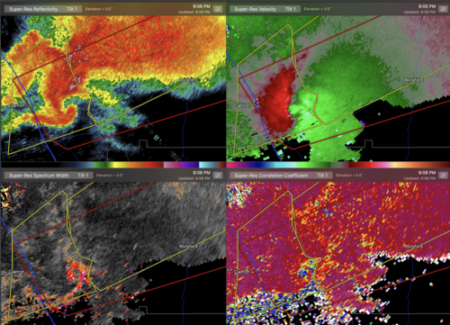
Josh Johnson at WSFA in Montgomery just posted on his Facebook that the tornado that lifted near Childersburg, AL may have been on the ground close to 100 miles. And the tornado that hit James Spann's home is reported to have been on the ground as the storm crossed into AL from MS, and may have still been on the ground when the storm crossed into GA. Now I'm inclined to think these were several different tornadoes originating from their respective storms, but if these numbers verify that is staggering. The one that allegedly crossed AL could end up making a run for the longest confirmed track on record if it verifies. Absolutely insane.

I think the earlier Spann-affecting storm was still tornadic into NW Georgia near Cave Spring. The dissipated circulation eventually passed perilously close to my family member's home in Floyd County, doing considerable tree damage in the area.
 
Turns out that the home itself had minor damage but trees were snapped and uprooted on his property. It is livable.
His wife was in shelter and is fine.

Ginger Zee is staying overnight and I believe she is doing to do a story on the irony of his home getting struck while he was on the air. My guess is it will be on GMA or, more likely, World News Tonight.


I'm not sure where in that tornado warning there's reference to hail being the main threat, as by definition, a tornado warning and any SWS on a tornado warning implies a tornado is the main threat.
 
Another supercell produced classic tornado signatures and damage in southeast Alabama around 9-9:15pm.
 

Attachments

  • Screen Shot 2021-03-25 at 9.49.03 PM.png
    Screen Shot 2021-03-25 at 9.49.03 PM.png
    2.3 MB · Views: 0
Better hope the storm weakens / dies or has a long benign cycle before it moves into the highly populated areas near Atlanta.

Update: Looks like Newnan, GA may have taken a direct hit from a massive tornado judging by radar signatures and debris aloft. This may be the most dangerous and destructive tornado of the day. Tornado Emergencies now being issued for this storm.
 
Last edited:
First thought is the the long-track tornadoes indeed followed outflow boundaries from morning rain. However it had to be south of the stable air. While deep layer parameters were lower down there, low-level parameters were maximized (SRH and low-level CAPE). Winds were backed on the boundary and the surface heated up at/south of it.

Second both ARW versions sniffed out the northeast Alabama mess again. HRRR was just crazy. NAM pushed for a big warm sector, but was not as robust as the HRRR. Felt like ARWs caught the evolution best though.

Finally I believe moderate to high parameters, but not pegged out, are best for chasers. How we got there could be debated. Anyway the long-trackers were south of the maxed out indices. Just the low-level details were quite important.
 
Back
Top