2021-03-25 EVENT: AR/LA/MS/AL/TN/KY

PDS Tornado watch out with >95/>95 tornado probabilities. I'm going to meander over towards Tupelo here shortly. Clearing per vis sat has been on most of this morning from Starkville to Columbus to Tupelo and West Point area. I feel like might be one of the biggest corridors for violent tornadoes later with HRRR and NAM soundings showing 0-1 SRH of 300.
 
LSI values are starting to cool, showing the erosion of CINH across much of the risk area, and latest RAP analysis shows that said trend will continue to occur ENE as the 500 mb perturbation approaches from the WSW and the pre-frontal trough starts to push east while the main surface pressure gradient tightens to the NNW, which will all help ignite the show relatively soon I suspect. Vis sat continues to show a nice area of clearing across the greatest threat areas, i.e., the golden triangle region.

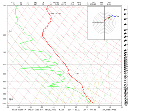
The 15Z JAN sounding already shows the environment well-primed then, with ample SRH and profiles supportive of rotating updrafts, and an environment for good vertical parcel acceleration too (see below). I'd expect a 20z special sounding or two as well.

1616692623357.png
 
I'm curious how those veered surface winds in MS will impact things today. Shear values are obviously impressive but a lot of that seems to be coming from the large amount of speed shear. I don't see a ton of directional shear, which is supported by the relatively straight line hodograph Jesse just posted. I could be wrong and the combination of strong instability and speed shear will be enough to get it done today. I just always get wary when surface winds aren't at least out of the due south.
 
On a side note, and apologies if this is inappropriate here, but the new NWS mosaic radar is terrible. Does anyone have a decent replacement? I found the College of Dupage site, which is nice, does anyone know of a better alternative?

You are completely right, the Mosaic is horrible. As for alternatives, Accu-weather has a national radar Mosaic that's a little better, mainly in the sense that it actually loads and doesn't stop mid way. However the site is advertisement heavy and annoying.
 
I'm curious how those veered surface winds in MS will impact things today. Shear values are obviously impressive but a lot of that seems to be coming from the large amount of speed shear. I don't see a ton of directional shear, which is supported by the relatively straight line hodograph Jesse just posted. I could be wrong and the combination of strong instability and speed shear will be enough to get it done today. I just always get wary when surface winds aren't at least out of the due south.

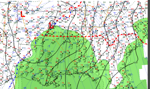
Just taking a closer look it appears winds are better backed further northeast in the golden triangle region, but it is a valid observation on the special JAN sounding. This looks to be a product of previous convective activity, frontal placement and deepening cyclogenesis relative to the position of the warm front as well, which was just south of JAN at 15z. The CI seems to be co-located with this pre-frontal wind shift axis moving ENE, where winds are more southeasterly from Oxford-Tupelo-Muscle Shoals-Savannah, TN, so that region east of the wind shift and proximal to the WF southeast of the main surface low will be a prime area to watch over the next few hours. You can definitely see the thermal gradient as the WF has peregrinated towards the US 78 corridor.

1616695339202.png
 
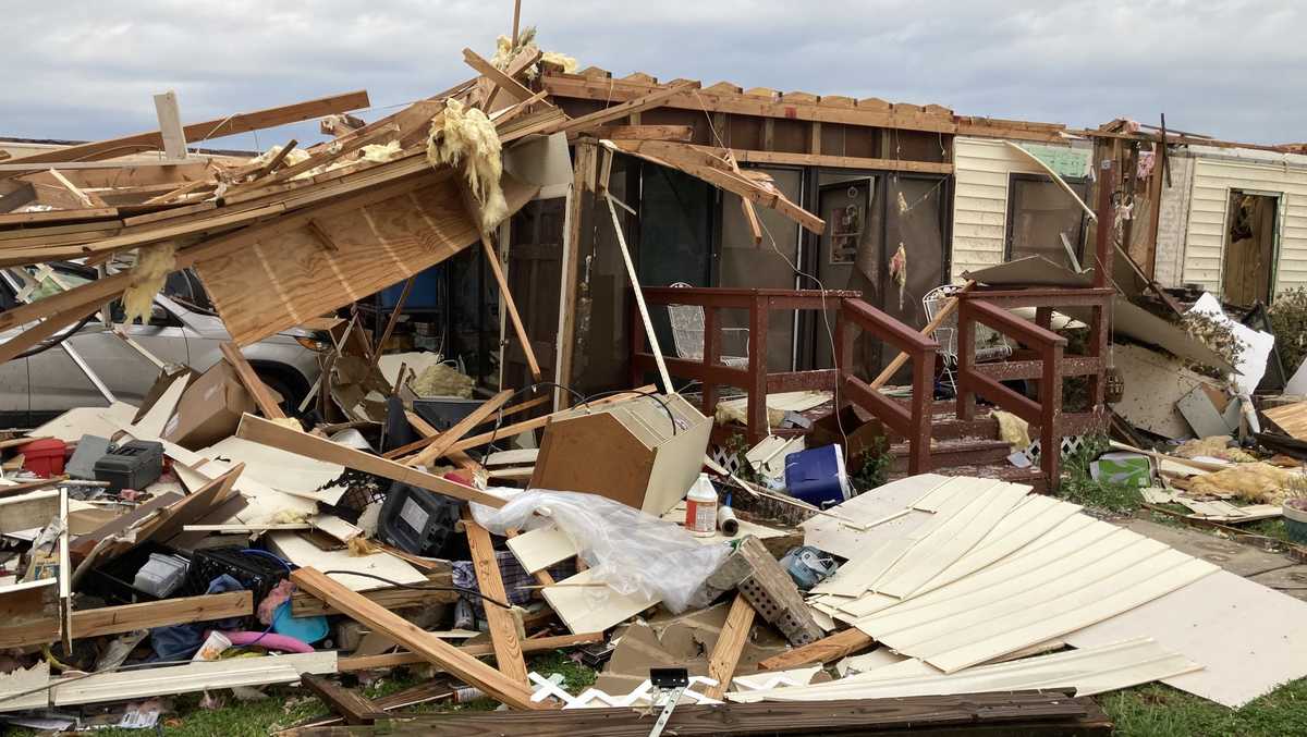
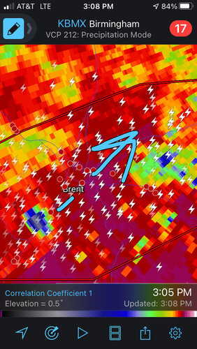
A cyclic supercell has produced damaging tornadoes south of the Birmingham, AL area with major damage in Helena and Pelham.. Terrain, HP nature and low LCLs are making it nearly impossible to see. I heard a chaser utter the "<expletive>, that was close" phrase on stream. Be careful out there!
 
A cyclic supercell has produced damaging tornadoes south of the Birmingham, AL area with major damage in Helena and Pelham.. Terrain, HP nature and low LCLs are making it nearly impossible to see. I heard a chaser utter the "<expletive>, that was close" phrase on stream. Be careful out there!

These cells are taking advantage of the more ambient 0-3km MLCAPE and surface vorticity in an environment of rich H85 Theta-e on the periphery of that better instability axis. That axis should continue to shift north and east with the 850 mb jet core over the next 3-4 hours.
 
A cyclic supercell has produced damaging tornadoes south of the Birmingham, AL area with major damage in Helena and Pelham.. Terrain, HP nature and low LCLs are making it nearly impossible to see. I heard a chaser utter the "<expletive>, that was close" phrase on stream. Be careful out there!
A little after 2 pm, James Spann reported on-air (ABC 33/40, Birmingham) that there had been "major damage" at his house. His wife was in shelter and was not injured.
 
Unconfirmed reports of a storm chaser taking a direct hit by a wedge and / or in an accident. This is UNCONFIRMED, but multiple reports on social media.
I don't know if these chasers were hit by the wedge, but I was watching their stream and saw a vehicle make a turn right in front of them just east of Centreville about 522pm cdt.
 
Josh Johnson at WSFA in Montgomery just posted on his Facebook that the tornado that lifted near Childersburg, AL may have been on the ground close to 100 miles. And the tornado that hit James Spann's home is reported to have been on the ground as the storm crossed into AL from MS, and may have still been on the ground when the storm crossed into GA. Now I'm inclined to think these were several different tornadoes originating from their respective storms, but if these numbers verify that is staggering. The one that allegedly crossed AL could end up making a run for the longest confirmed track on record if it verifies. Absolutely insane.
 
Back
Top