Jeff House
Supporter
Morning Rain Afternoon Pain is some of both correlation and causation. Typically a short-wave coming out of the main trough is responsible for the morning rain. Same main trough is responsible for the evening severe as another short-wave ejects.
Causation part is outflow boundaries. Morning rain will lay down the outflow boundaries we chasers seek. OFBs can have SRH similar to that of the warm front; and, the OFB may have greater instability farther south. These boundaries from morning rain are part of causation. Also other variables like rate of destabilization may be more impactful than just a snap shot of it.
I generally prefer to chase OFB over WF. They both have plenty of SRH. Tie goes to the OFB which can have greater instability with which to work. Especially when it's cool on the north side of the WF, I prefer the OFB. There are times the OFB may be capped; and, I might prefer the WF. If that's late in the season there's probably plenty of instability near the WF. Depends on the situation but I normally go for the OFB.
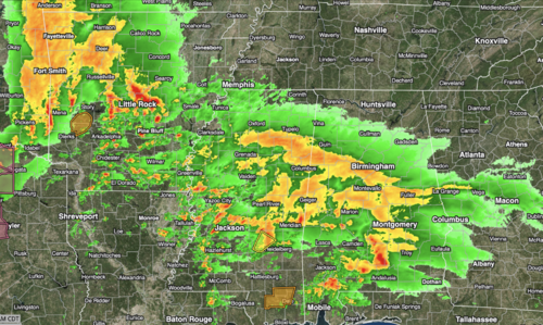
Alabama tornadoes on March 17 indeed favored the intersection of the outflow boundary and a pre-frontal trough approaching. South pre-frontal trough is to Plains dry line. Intersection with outflow boundary (and warm front) are areas of interest.
Big days they both go anyway. Just wanted to tie together a common chase strategy OFBs with the morning rain discussion.
Causation part is outflow boundaries. Morning rain will lay down the outflow boundaries we chasers seek. OFBs can have SRH similar to that of the warm front; and, the OFB may have greater instability farther south. These boundaries from morning rain are part of causation. Also other variables like rate of destabilization may be more impactful than just a snap shot of it.
I generally prefer to chase OFB over WF. They both have plenty of SRH. Tie goes to the OFB which can have greater instability with which to work. Especially when it's cool on the north side of the WF, I prefer the OFB. There are times the OFB may be capped; and, I might prefer the WF. If that's late in the season there's probably plenty of instability near the WF. Depends on the situation but I normally go for the OFB.
Alabama tornadoes on March 17 indeed favored the intersection of the outflow boundary and a pre-frontal trough approaching. South pre-frontal trough is to Plains dry line. Intersection with outflow boundary (and warm front) are areas of interest.
Big days they both go anyway. Just wanted to tie together a common chase strategy OFBs with the morning rain discussion.