2021-03-17 EVENT: AR/LA/MS/TN/AL/GA

One of the "good" things about yesterday was the lack of a major city being hit. I think if a highly-populated area had suffered a strike, we would be having a different conversation. Birmingham came very close twice, as did Selma. There were some really intense (albeit brief for a high risk day) velocity and debris scans yesterday, but they were over sparsely or non-populated areas.
 
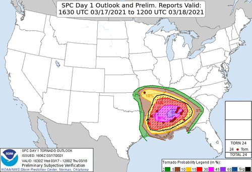
Based on preliminary SPC reports from yesterday after the 1630z 45% hatched was issued, I'd say the event underperformed by quite a bit! While there were several tornadoes in Central/Southwest Alabama and even a few in Southeast Mississippi, I'd say it fell short of what one would expect with a 45% hatched area (IE 5/24/11, 4/7/06, 4/27/11, 4/14/12 as just a few examples of other events of that same probabilistic category). Although from a locals standpoint, if you were impacted by any single tornado yesterday, it was a big deal and you will probably remember it for a long time (this is true with any weather event, people remember what impacts THEM).

From a chasing standpoint, I think the really poor low-mid level lapse rates later in the day hurt the potential along with weak surface flow in the warm sector. Back to the west there was veering at the surface over much of Mississippi and some VBV noted on the 18z Jackson, MS sounding. The best backing at the surface and 850mb was over Central/Southern Alabama during the afternoon hours (which I'd have expected looking at the upstream New Orleans LA sounding at 18z, noting this was advecting northeastward.

Much of the northern half of the state (AL/MS) had been convectively overturned by mid afternoon as repeated rounds of storms initiated as early as late morning (with a strong looking tornado SE of Laurel, MS). The late afternoon-evening supercells from Silas, AL over toward Montgomery, AL were definitely the main show for the chasers that were able to drop that far southeast in time to see them. Doesn't seem like much became of the second late round along the main front where the main forcing was, which was meant to be the main show. Thankfully I haven't heard of any big towns that have been hit so that is very good news! Overall it seemed like a tough chase day, I ended up sitting out as I had some concerns, so this is just me Monday morning quarterbacking lol. Always good news though when we don't wake up to a bunch of devastation, nobody likes that...

We will just have to wait on surveys and ratings now to see how strong the tornadoes that did occur were (notable ones near Laurel MS, Silas AL, Campbell AL, Brookwood AL, and Gardendale AL!

45 hatched verification.gif
 
I did not do all that much analysis for this event, beyond reading SPC products and looking at a little model output, and while it unfolded I was at work so did little more than check radar every now and then, and read a few MSDs. From what little I had seen leading up to the event, it looked like conditions were most favorable in MS, but reading the storm reports this morning shows almost all of the tornado reports were in AL. Not surprised by the number of TOR reports in AL, but surprised there weren’t more in MS. I assume this is mostly attributable to the factors @Ethan Schisler noted above? Any additional post-mortem thoughts?

I didn't do a huge amount of analysis either, but I did watch things unfold. The main reason for the shift from MS was simply a faster system, the line that was in central MS in 24 h forecasts ended up verifying in AL yesterday evening. MS was totally overworked by crapvection by that time. There were VBV issues as well but the main thing was just, as Jason said, too much convection and lousy storm modes. The 1500-2000 CAPE that sounding indicated was sufficient but hardly impressive,. Sufficient clearing and recovery simply did not happen. Watching the live streams all I saw as rain, rain and more rain, and a few chasers wowing at supposed wedges that were obviously just messy mesos. I agree with Warren above, although i'm skeptical whether even major population centers would have seen EF 3+ damage from any of the cells yesterday.
 
I wonder if lapse rates were a bit of an issue yesterday. I think it was mentioned yesterday that the lapse rates across at least part of the warm sector were a bit underwhelming. I had James Spann's stream going most of the afternoon while I was at work and a couple of the live streams they were showing had some very impressive rotation (especially considering I was seeing it on the stream and not in person) but there seemed to be a lack of upward motion. I wonder if the lower lapse rates hampered vertical motion, despite the impressive rotation in a lot of the storms.
 
Based on preliminary SPC reports from yesterday after the 1630z 45% hatched was issued, I'd say the event underperformed by quite a bit! While there were several tornadoes in Central/Southwest Alabama and even a few in Southeast Mississippi, I'd say it fell short of what one would expect with a 45% hatched area (IE 5/24/11, 4/7/06, 4/27/11, 4/14/12 as just a few examples of other events of that same probabilistic category). Although from a locals standpoint, if you were impacted by any single tornado yesterday, it was a big deal and you will probably remember it for a long time (this is true with any weather event, people remember what impacts THEM).

From a chasing standpoint, I think the really poor low-mid level lapse rates later in the day hurt the potential along with weak surface flow in the warm sector. Back to the west there was veering at the surface over much of Mississippi and some VBV noted on the 18z Jackson, MS sounding. The best backing at the surface and 850mb was over Central/Southern Alabama during the afternoon hours (which I'd have expected looking at the upstream New Orleans LA sounding at 18z, noting this was advecting northeastward.

Much of the northern half of the state (AL/MS) had been convectively overturned by mid afternoon as repeated rounds of storms initiated as early as late morning (with a strong looking tornado SE of Laurel, MS). The late afternoon-evening supercells from Silas, AL over toward Montgomery, AL were definitely the main show for the chasers that were able to drop that far southeast in time to see them. Doesn't seem like much became of the second late round along the main front where the main forcing was, which was meant to be the main show. Thankfully I haven't heard of any big towns that have been hit so that is very good news! Overall it seemed like a tough chase day, I ended up sitting out as I had some concerns, so this is just me Monday morning quarterbacking lol. Always good news though when we don't wake up to a bunch of devastation, nobody likes that...

We will just have to wait on surveys and ratings now to see how strong the tornadoes that did occur were (notable ones near Laurel MS, Silas AL, Campbell AL, Brookwood AL, and Gardendale AL!

View attachment 21280

This all localized itself into much of Alabama. You know, yesterday underperformed, but however, these tornadoes were significant and destructive. So it did not bust. It was actually more like a localized outbreak, which the bulk of it was in Alabama. The main issue was the overcrowding of the warm sector. The warm front did not move into Tennessee as forecasted, but instead it stayed in Birmingham. There's still a chance that this turns tornadic around midnight but thank goodness it wasn't much worse. For the people who have been affected by these tornadoes, my heart goes out to them and I hope they can gain the strength and resiliency to soldier on with the recovery efforts.
 
It looks like the strongest tornado surveyed so far has been a high end EF2 in Wayne County, MS. NWS Tallahassee has crews out today and I assume NWS Birmingham and NWS Mobile do as well, but no word on any surveys from those offices yet. I don't have Twitter, so it may be possible they have been posting updates there. Regardless, Dixie dodged what had the potential to be a very serious bullet.
 
Ethan mentioned about Mon morning quarter-backing, I don't think that's the case really. I see it as a opportunity so long as its not filled with "I told you so's", no body likes that. it's a lessons learned kind of thing and post analysis is as good as Pre. I would tend to agree that Lapse Rates, an over abundance of mixed modes, and especially coverage over a large area, messed around with some laminar flow in some spots, while in others it was probably overturning, lack of abundant insolation and atmospheric reset. Obviously in some locations, where those ingredients aforementioned were lessened, the better storms happened. Did the SPC over do it? well its probabilities driven so no initially, but by the morning of day 2? maybe a bit ( more to follow about chart evolution). All in all, I think the timing thing was one problem, another issue was the cold air damming and latent convective cloud cover that was still present on day 2 ( yesterday ), over much of SC and NC which because of the timing of the system the previous day, and slower clearing and over abundance of moisture cooled air, screwed up much of their Day 2 forecast and as you probably noticed they down trended the severities during their updates. it took til about 18-20Z before most of SC/NC cleared out and started to warm up enough for things to pop and when they did, it was almost exclusively on the retrograding warm front.

I was comparing Apr27th2011 to this system, just for S&G's, and I'll keep it short because we could dissect this to a much larger convo haha, but even just a quick look at the upper air, and radar analysis, you can see a vast difference, basically non-existent, in amount of convection present prior to the main event which I think in part was spurred on by the track of the 500mb low and probably a stronger CIN region ahead of the sfc boundary ovr MS/AL. Now, I didn't compare Skew-T's, but I am sure some parallels could be made as will all major systems. So yeah, poor Lapse rates, little to no CIN , timing fluctuations, multiple rounds of convection , no diurnal reset, were possibly the driving factors in quashing a SPC Probabilities driven forecast in this instance.

Apr27th 2011 SPC's Day 1 : SPC Severe Weather Event Review for Wednesday April 27, 2011
there is verification built in there as well.. some interesting stuff to go back in on and learn from.

Chart Evolution... I wonder 2 things( and I am also guessing here so Im not speaking from experience or personal knowledge)... SPC forecasters over the years, I got to the point where I knew the forecasters who always did the charts, they probably had been there doing the job for 20plus years and used to a certain way of doing things ( Thompson, Rogers, Cohen Daniels, Racy ) are just a few.. but I had wondered if maybe some changed or CAMS modeling is now more a part of the process to create operational products?.. in one instance recently.. this past week, Severe was forecasted for OK/AR/KS in a small area, but I was looking at the past charts forecasted for the same day, just to see what had changed or remained consistent. Over Iowa Minnesota, 2 days prior they were just inside a general area, on the day of, they were inside an enhanced area. now I'm not calling them out, things change as models do to, but it just made me think , about , but it seems like more so recently, there have been more instances of seeing things change a bit more drastically than in other times so it just made me wonder if new folks have replaced legacy older ones?, different methods of production are being done. some of you probably have a better idea than I.
 
Last edited:
Wednesday I did not chase, thank you NIT for keeping me from an early season mistake. However I watched closely for work, and then for personal interests. Here's my take on Wednesday.

My earlier post in this thread forecast that the pre-frontal trough moving from the Delta into Mississippi would be the main show, somewhat in line with SPC thinking. Instead free warm sector convection tempered CAPE just enough to avoid numerous Mississippi tornadoes. However there were some down below I-20. North Mississippi the issue was not VBV; that high up in the Hodo is either neutral or actually bullish for ventilation. However I believe the double warm nose might have cut down on production. One warm nose is a good EML. Two is, kind of noisy. On the other hand plenty of cells fired in North Mississippi; so, maybe it was plain old cell interference.

Outflow boundary was the key for Alabama. Synoptic warm front actually made it into North Alabama and finally crossed the Tennessee border. However a separate outflow boundary lurked down near Birmingham. Models had all of this. However I believed the Alabama convergence zone would be blob-fest. It was north of the outflow. Obviously along and just south of the said outflow produced plenty. Also discerned a second pre-frontal trough in Alabama. Those veering Mississippi winds, and still backed south of the Alabama outflow. The intersection of the two was a focal point around Tuscaloosa. Started south of TCL and went again later north of TCL. It's not a Dixie Day without Cullman, Alabama.

Action southeast of Birmingham actually happened earlier in the day than any of the above. All I can come up with there is lead short-wave and outflow. I could not discern another intersecting boundary, but it's harder in the morning. Boundaries usually become more apparent late morning both surface charts and visible satellite.

For work I made the mistake of comparing it to 4/28/14 or Easter 2020. Caught up in the Highpe. In hindsight that was silly. This was a March event and those are April days. Nashville last year and 3/2/12 might have been better. No surprise they are March! At the risk of being too frank, this never had a chance of being like 2011. That day 500/200 mb were much closer to straight out of the west; and, instability was much higher. That day was a Great Plains dry line smacking into Deep South moisture. LOL no way!
 
It is very difficult to get a genuine "high risk" day without two factors, one of which will surprise some readers...
  • Negatively tilted system. This was the case with April 27, 2011. With a closed low like we had last week? Almost no way.
  • Convection in the morning. After having done a synoptic climatology of numerous (I think it was something like 50) F-4 and F-5 tornadoes, more than 90% occur with convection earlier in the day. There seems to be something about thunderstorms/reload/supercells that produces "the big ones." Of course, a major squall line with QLCS tornadoes occurred the morning of 4-27-11.

Interesting observation about “convection in the morning,” but, correlation not being causation, couldn’t convection in the morning just be a byproduct of the parameter space that is in place on a big day? On the bigger days, moisture is already in place the day before, then you have the approaching strong dynamics (and/or a lifting warm front) and you get morning convection. Then the atmosphere is worked over, so you need a lull if the instability is to be reloaded. With the more powerful systems, you have multiple short waves coming through, so you get more lift coming in at the right time later in the day. So the morning storms may have nothing to do with *producing* “the big ones“ - after all, morning convection has ruined many otherwise promising chase days. Instead, the parameters of a big day are simply more likely to produce morning convection?
 
g causation, couldn’t convection in the morning just be a byproduct of the parameter space that is in place on a big day? On the bigger days, moisture is already in place the day before, then you have the approaching strong dynamics (and/or a lifting warm front) and you get morning convection. Then the atmosphere is worked over, so you need a lull if the instability is to be reloaded. With the more powerful systems, you have multiple short waves coming through, so you get more lift coming in at the right time later in the day. So the morning storms may have nothing to do with *prod

This was my thought too. EF4/EF5s generally require a very favorable environment, and morning convection can act in lieu of a cap by washing out instability and allowing it to rebuild for a more favorable time, for example with a shortwave out ahead of the main system. These potent systems often reload the atmosphere rather quickly with multiple rounds of tornadic storms, where I agree the earliest convection of the day is either non-tornadic or less tornadic, like with 4/27/11.

Morning convection can also produce a whole network of outflow boundaries which can in some cases increase severity of the storms that are able to latch on later in the day.

Of course, morning convection can also wash out the entire day and ruin instability. However, those days likely aren't high end EF4/5 producers anyway.
 
Interesting observation about “convection in the morning,” but, correlation not being causation, couldn’t convection in the morning just be a byproduct of the parameter space that is in place on a big day? On the bigger days, moisture is already in place the day before, then you have the approaching strong dynamics (and/or a lifting warm front) and you get morning convection. Then the atmosphere is worked over, so you need a lull if the instability is to be reloaded. With the more powerful systems, you have multiple short waves coming through, so you get more lift coming in at the right time later in the day. So the morning storms may have nothing to do with *producing* “the big ones“ - after all, morning convection has ruined many otherwise promising chase days. Instead, the parameters of a big day are simply more likely to produce morning convection?

Good morning, Jim and Patrick,

You may be correct. As stated, I was listing "two factors" not "two causes."

For example, it was foggy and rainy until mid-afternoon for both Great Plains (a/k/a "Woodward") Tri-State Tornado (1947) and the Topeka Tornado (1966). Then, it cleared up for a couple of hours. The supercell then developed and the rest is unfortunate history.

Mike
 
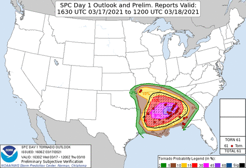
45 hatched verification 6.gif

With the latest surveys out now, it brings Alabama's 3/17/21 tornado count to 25 which makes it their 6th largest tornado outbreak on record. Most all tornadoes were less than EF2 with a few EF2 and one long track tornado from Southwest MS to Putnam, AL which was rated an EF2 (a few chasers got this one and it was fairly visible at times). I'd say from a high risk point of view, it probably verified over Alabama, but the Mississippi portion of the risk certainly did not. Shift that 45% hatched about 60 miles SE and you have perfect verification, but its not a perfect world we live in...so it comes down to perspective really. If you were living in Central/Southern AL and got hit by that train of tornadic supercells from mid day to evening, it probably felt like a long day to you and the forecast certainly panned out. If you were back west toward the Delta and was waiting on that second wave of tornadic storms in the afternoon/evening, you were probably like "what is all the fuss about?".

All about where you are and perspective....I should note that in my first post I never called it a "bust", but said it underwhelmed and I think from a strong-violent tornado perspective on what one would expect with such a risk caliber...it indeed did underwhelm quite a bit (many short tracked, brief, weaker tornadoes in that zone). That isn't always a bad thing though. Nobody wants to see EF3-EF5 tornadoes blasting through communities and homes, and destroying lives. Because to be frank, if you are getting an EF4 or 5 rating, that is what it probably took. So on that note, I'm thankful! Hopefully we get lucky on Thursday and its the same sort of deal, minimum amount of folks affected!
 
Back
Top