• A friendly and periodic reminder of the rules we use for fostering high SNR and quality conversation and interaction at Stormtrack: Forum rules

    P.S. - Nothing specific happened to prompt this message! No one is in trouble, there are no flame wars in effect, nor any inappropriate conversation ongoing. This is being posted sitewide as a casual refresher.

2021-03-17 EVENT: AR/LA/MS/TN/AL/GA

Patrick K

EF0
Joined
May 2, 2019
Messages
24
Location
Southeast USA
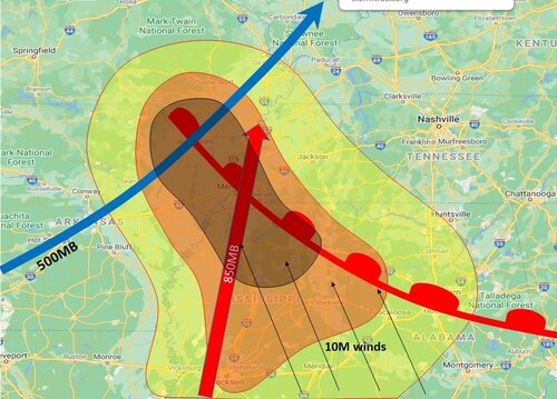
Global models are in reasonable agreement of an upper low moving from near the OK panhandle toward the lower MO valley during the day on Wednesday. A warm front will push northward from central MS/AL toward the TN border by 20Z. A broad area of upper-60s dewpoints seems likely with instability building through the afternoon hours, although the warm sector appears to be mostly uncapped, particularly out ahead of the low. Shear, both bulk and directional, appear favorable for supercells across a wide area.

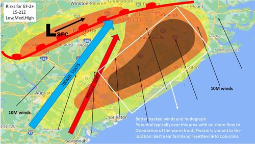
Given the lack of cap and strong instability, it looks like several rounds of initiation will occur, with the initial position of the warm front on Wednesday influenced by Tuesday night's storms across MS/AL/GA. The NAM3k depicts a round of storms moving from eastern AR into northwestern MS and into southwestern TN in the morning hours, crossing the warm front. A second round of initiation appears to follow in the wake of the early morning storms, along/invof the warm front in the early afternoon hours, around the Memphis area and MS/TN border, generally. The 20z-00z timeframe seems to be the real show, with supercells erupting in this timeframe across a broad swath of the warm sector into a highly destabilizing environment. Forecast soundings show long, clockwise veering hodographs with the LLJ ramping up out of the southeast into the evening hours, presumably maximizing the tornado risk around this time.

Question marks seem to be around warm front placement, cloud cover and ongoing precipitation affecting instability and storm timing, plus the lovely area that Dixie is for storm chasing. After chaser convergence on a narrow setup in the TX panhandle this weekend, it seems there will be much less chaser convergence for this broader setup, but also... trees, lot of trees.

I would target the Byhalia, MS area around lunch time and watch those presumed round of storms, with expectations to catch the early evening storms in that same area later in the day, keeping a close eye on the fine-scale details as they develop that afternoon.
 
One thing I like about Wednesday's setup as opposed to most Dixie alley setups is the presence of steep lapse rates on most of the soundings I've pulled up over Northeast AR/West TN/N MS. I feel like though it could be predominantly a nocturnal show though, however if you get any discrete supercells in that type of CAPE+shear combination being modeled, I would imagine a couple intense caliber tornadoes are certainly in the cards. Whether they are chaseable or visible is another question.

If I had to pick a target right now, I'd probably say somewhere in Northeast Arkansas and hope for a daytime initiation in decent terrain. Northern MS/AL/S TN for nocturnal tornadoes along the warm front seems to be a good bet, but that area is rough chasing and I don't think I wanna get into a situation where I'm looking down more fast moving wide tornadoes with limited visibility.

On the fence as to whether I will actually chase this though, it's only a 6 hour drive, but gas prices are soaring over $3 a gallon here...so gotta pick and choose this season wisely.

If it slows down though, there could be something further west on the actual low pressure itself. The overall synoptic setup gives me vibes of May 10, 2008 tornado outbreak in the Deep South.
 
A few things have changed with this setup, notably the timing. CAMs continue to show 3 rounds of initiation, the first lifting northward with the warm front in the morning, the second afternoon round is notable with storms spread across the open warm sector where there is little capping into MS/AL but also no clear forcing mechanism. Presumably, differential heating from broken clouds is driving this, and while Dixie seems to usually produce in similar situations, I am a bit skeptical here for the same reasons in my initial post. Instability could be limited with heavy cloud cover and/or ongoing crapvection. If you're skeptical like me, a triple point play on the 2nd round of storms in NE AR could be in order and besides the MS river issues, this would be a more ideal chase location.

The third round, driven by actual forcing, appears to have slowed down slightly in recent model guidance. So in addition to trees, darkness could become an issue for chasers. The ultimate position of the warm front appears placed more southerly now, so I think this 3rd round may be better chased from further south in south central MS into AL.
 
Just based on the lead in to this system, scouring over the short term CAMS and SREF and medium runs of the NAM, I get this feeling that the general synoptic setup really puts the highest risk box from Jonesboro, East thru Memphis and Jackson TN, and from Greenville MS, East to Tupelo. The southern end of that box seems slightly more conducive once warm frontal surge begins but its a big question as to how much clearing can happen to boost up temps. the northern end seems to get the stronger mid level dynamics. I think the wrinkle will be just how much clearing can occur or will there be a lot of elevated convection around to limit the insolation diurnal recharge. which may be the case closer to the warm front, but further south they may end up getting some clearing which could amplify the threat there later in the period... well because I am just slightly bored at the moment.. I made up a really quick visual. Just for fun, that's all .. Best Chances for EF-2+ in the darkest shade 20-02Z
 

Attachments

  • Tornado Risk.jpg
    Tornado Risk.jpg
    271 KB · Views: 0
Last edited:
My target area was, and still is, Memphis TN. It provides a great location to move into NE Arkansas or south into Mississippi for any "round 2" storms that can stay discreet and rotate.

I considered a chase tomorrow, but my concern about "round 1" convection polluting the area, cell speed, coupled with lack of desire to chase the wide area nocturnal show in the jungles of MS/AL, kept me at home.

Watch the Jonesboro to Pine Bluff, AR area for the afternoon show and try to get them before the nocturnal show lights off farther SE into MS and AL.
 
Likelihood of supercells initiating in the flat clear Delta makes Wednesday somewhat interesting. However the Delta is not that wide and storms will move quickly; so, the easy show may be brief.

Also appears two surface troughs will be in between the cold front CF and warm front WF, which sometimes happens in Dixie Alley. A quasi-dry-line like feature in central Arkansas (ahead of the CF) may go late afternoon, moving toward the Delta evening. This line could have some supercells.

The second pre-frontal trough will be east of that, a convergence zone still west of the warm front / southern Apps mess. Said pre-frontal trough should explode in the Delta late afternoon and through West Tennessee and Mississippi evening. I would probably chase this line, unless it's too sloppy. Line just to its west could be a backup plan.

I don't like anything too much farther east because of terrain. North Central Alabama is decent terrain again (relative terms here) but it'll be after dark then. However Alabama faces the real threat of a strengthening LLJ increasing low-level shear at night.

I also don't like the afternoon warm sector stuff near the warm front because it'll probably be sloppy. Delta seems like the only play, if one can keep up with the storms.
 
Jeff House QUOTE
I don't like anything too much farther east because of terrain. North Central Alabama is decent terrain again (relative terms here) but it'll be after dark then. However Alabama faces the real threat of a strengthening LLJ increasing low-level shear at night.

I also don't like the afternoon warm sector stuff near the warm front because it'll probably be sloppy. Delta seems like the only play, if one can keep up with the storms.
[/QUOTE]
I agree with your southern Alabama nocturnal LLJ increase past 00Z, could be a pretty intense QLCS - BKN line with embedded LEWP tornadoes over that area supported by deeper moisture field and real strong 60kt LLJ Theta-e region form the gulf coast up through I-85. With so Much PW , it's gonna be tough to chase anyway with any pre-frontal discrete cells being HP for sure, and the worst is the QLCS / frontal nocturnal embedded circulations. All moving at 50mph and faster? over rolling hills and heavy foliage areas? yeah no thanks, chasing in the south is definitely more complicated in some ways.

The best play IMO is the River Delta east of Pine Bluff , Tupelo west , Memphis region with passing Vort lobes, best 500mb diffluence - pre frontal trough interplaying the warm front. The complications over this are are outflows cold pool interactions from early morning convection, limited clearing, and not the healthiest Lapse Rates across the area. So I think one of the wrinkles is overall clearing for total instability, but I think even with a BKN skycon, the dynamics and Theta advection strength may offset a chunk of it but, it also may limit the discrete formation further south until it gets closer to the cold frontal passage, tough forecast there for sure.

After that, and as the front becomes more of a solid BKN to solid line with embedded structures, it's selected areas of better chase visibility over Cntrl MS to AL. but by then its way past dark and a chase nightmare.
 
Central Mississippi is experiencing solid insolation to start the day which will only add to the instability. Morning soundings show an EML advecting over the warm sector with steep lapse rates over a very moist boundary layer. Morning models show discrete/semi-discrete supercells across the risk area this afternoon and evening. All indications suggest a major tornado outbreak is on tap today.
 
This is shaping up to be a partly nocturnal, classic Dixie Alley tornado outbreak. Not good for those areas in Mississippi and Alabama, where people will be out celebrating St. Patrick's Day. Also notable: today is the first SPC high risk day in March since 2012, per Wikipedia.
 
I chose to sit today out on purpose, I didn't like the terrain, storm mode, and the fact that things could linger well after dark. However I have a couple chase partners that have ventured south for the day so I'm wishing them the best of luck and hoping for some good visibility for those guys. I think if I had to pick a target I'd be sitting in Columbus, Mississippi this afternoon waiting on open warm sector development. I've been watching this Columbus to Jackson, MS area for a while and as of 10am, I'm still liking what I'm seeing.

If I want a guarantee of getting on severe storms in good terrain, I'd probably hop northwest toward Batesville, MS. I've chased there a few times and its not awful. Although I have concerns about areas further west being more quasi-linear with convection (although this doesn't mean there won't be strong tornadoes, just very hard to spot and fast moving). I think the eastern target over Eastern MS/Western AL is a better bet for a sustained long tracked violent tornado (perhaps similar to what we saw last year on Easter). As with everything weather though, it just takes one or two ingredients to be slightly out of place to make for a total mess.

Right now though I'd stand at Columbus, MS around 20-21z, adjust from there. Long day ahead! Good luck to all chasing!
 
Based on the latest trends, I'd probably adjust my target southeast to Meridian/Hattiesburg, MS over toward Montgomery, AL. A lot of convection has gone up in the warm sector well ahead of the main front further to the west. The BMX 18z sounding showed an awesome wind profile with great hodograph, however limited instability/lapse rates. Jackson 18z sounding shows a bit of veer back veer around 700mb, although looking back to the S/SW near New Orleans, shows better soundings with less issues with regards to VBV and lapse rates.

I'd probably hope something comes out of that cluster that is moving from Louisiana/Arkansas into Mississippi and see if anything can remain discrete. Environment over much of Mississippi and Louisiana is still not quite overturned yet, although surface winds are veering a bit to the SW ahead of the front, this could back more toward 00z as the low pressure approaches. Certainly a messy chasing scenario as it stands now! Patience is key. There have already been several tornadoes reported in that corridor I mentioned including ones near Laurel, MS, Tuscaloosa, AL, and southeast of Birmingham as well. We will see what the rest of the afternoon holds.
 
After Watching today. There was so much going on with juvenile or crap-vection, that I think it some ways it was a blessing that more cells didn't produce large tornadoes. I think it was too moist, with too much in the way of total convection and not enough dry air clearing in the mid levels despite the major amount of shear instability. Where there were pockets of clean undisturbed air from near by convection, there were some small pockets with short duration breakouts, alot of the velocities I saw with the exception of a few cells were pretty low end and that's a good thing, the whole area got pretty lucky I think.

As this thing evolves over my area tomorrow, I kinda think the same, yes the area is warranted on general principle , yes the dynamics are there, but if its all tied to the main line of convection, it will be isolated and embedded mainly in local LEWP formations or embedded discrete.. The only place I see as of right now that seems plausible for more isolated discrete is Charlotte to Raleigh in association with a lee-side surface low that the models are picking up on; will certainly wait to see if that presents itself tomorrow with timing and location of the warm front interaction, but I've seen more than my fair share of tornado genesis from Greenville to Charlotte near and along I-85 due to this.

My second area is over the 95 Corridor from Charlotte to Florence, mainly from Raleigh/Fayetteville east to the near the coast and south from New Bern into Wilmington NC, with more backed winds coming off the water there and a bit more in the way of CAPE.

So again, just for my personal fun, I made a graphic.. and hopefully I will be out chasing to see how this pans out.
 

Attachments

  • TorSC-NC18Mar.jpg
    TorSC-NC18Mar.jpg
    236.2 KB · Views: 0
I did not do all that much analysis for this event, beyond reading SPC products and looking at a little model output, and while it unfolded I was at work so did little more than check radar every now and then, and read a few MSDs. From what little I had seen leading up to the event, it looked like conditions were most favorable in MS, but reading the storm reports this morning shows almost all of the tornado reports were in AL. Not surprised by the number of TOR reports in AL, but surprised there weren’t more in MS. I assume this is mostly attributable to the factors @Ethan Schisler noted above? Any additional post-mortem thoughts?
 
I kind of want to rescind my overnight post. with conditions as they are based on this mornings Obs , Low Cig/Vis all over the state and cooler SST's funneling moist but cooler conditions, the theta WAA transport while great, is not the best scenario today. the boundary layer is cool still and the satellite and Obs confirm that it will probably remain cloudy most of the day aloft, which will in turn keep temps tempered and the Vis slow to recover until winds and instability rapidly increase just prior to boundary passage. There is still plenty of kinematics, but I think our shot of seeing anything significant really ends up being where and if the sun can beat down on the ground in advance of the boundary which doesn't look all too likely until right now anyway. I am feeling pretty disappointed I didn't see this yesterday, but should have given the synoptic setup and timing. Mucho skeptical now.
 
One of the "good" things about yesterday was the lack of a major city being hit. I think if a highly-populated area had suffered a strike, we would be having a different conversation. Birmingham came very close twice, as did Selma. There were some really intense (albeit brief for a high risk day) velocity and debris scans yesterday, but they were over sparsely or non-populated areas.
 
Based on preliminary SPC reports from yesterday after the 1630z 45% hatched was issued, I'd say the event underperformed by quite a bit! While there were several tornadoes in Central/Southwest Alabama and even a few in Southeast Mississippi, I'd say it fell short of what one would expect with a 45% hatched area (IE 5/24/11, 4/7/06, 4/27/11, 4/14/12 as just a few examples of other events of that same probabilistic category). Although from a locals standpoint, if you were impacted by any single tornado yesterday, it was a big deal and you will probably remember it for a long time (this is true with any weather event, people remember what impacts THEM).

From a chasing standpoint, I think the really poor low-mid level lapse rates later in the day hurt the potential along with weak surface flow in the warm sector. Back to the west there was veering at the surface over much of Mississippi and some VBV noted on the 18z Jackson, MS sounding. The best backing at the surface and 850mb was over Central/Southern Alabama during the afternoon hours (which I'd have expected looking at the upstream New Orleans LA sounding at 18z, noting this was advecting northeastward.

Much of the northern half of the state (AL/MS) had been convectively overturned by mid afternoon as repeated rounds of storms initiated as early as late morning (with a strong looking tornado SE of Laurel, MS). The late afternoon-evening supercells from Silas, AL over toward Montgomery, AL were definitely the main show for the chasers that were able to drop that far southeast in time to see them. Doesn't seem like much became of the second late round along the main front where the main forcing was, which was meant to be the main show. Thankfully I haven't heard of any big towns that have been hit so that is very good news! Overall it seemed like a tough chase day, I ended up sitting out as I had some concerns, so this is just me Monday morning quarterbacking lol. Always good news though when we don't wake up to a bunch of devastation, nobody likes that...

We will just have to wait on surveys and ratings now to see how strong the tornadoes that did occur were (notable ones near Laurel MS, Silas AL, Campbell AL, Brookwood AL, and Gardendale AL!

45 hatched verification.gif
 
I did not do all that much analysis for this event, beyond reading SPC products and looking at a little model output, and while it unfolded I was at work so did little more than check radar every now and then, and read a few MSDs. From what little I had seen leading up to the event, it looked like conditions were most favorable in MS, but reading the storm reports this morning shows almost all of the tornado reports were in AL. Not surprised by the number of TOR reports in AL, but surprised there weren’t more in MS. I assume this is mostly attributable to the factors @Ethan Schisler noted above? Any additional post-mortem thoughts?

I didn't do a huge amount of analysis either, but I did watch things unfold. The main reason for the shift from MS was simply a faster system, the line that was in central MS in 24 h forecasts ended up verifying in AL yesterday evening. MS was totally overworked by crapvection by that time. There were VBV issues as well but the main thing was just, as Jason said, too much convection and lousy storm modes. The 1500-2000 CAPE that sounding indicated was sufficient but hardly impressive,. Sufficient clearing and recovery simply did not happen. Watching the live streams all I saw as rain, rain and more rain, and a few chasers wowing at supposed wedges that were obviously just messy mesos. I agree with Warren above, although i'm skeptical whether even major population centers would have seen EF 3+ damage from any of the cells yesterday.
 
I wonder if lapse rates were a bit of an issue yesterday. I think it was mentioned yesterday that the lapse rates across at least part of the warm sector were a bit underwhelming. I had James Spann's stream going most of the afternoon while I was at work and a couple of the live streams they were showing had some very impressive rotation (especially considering I was seeing it on the stream and not in person) but there seemed to be a lack of upward motion. I wonder if the lower lapse rates hampered vertical motion, despite the impressive rotation in a lot of the storms.
 
Based on preliminary SPC reports from yesterday after the 1630z 45% hatched was issued, I'd say the event underperformed by quite a bit! While there were several tornadoes in Central/Southwest Alabama and even a few in Southeast Mississippi, I'd say it fell short of what one would expect with a 45% hatched area (IE 5/24/11, 4/7/06, 4/27/11, 4/14/12 as just a few examples of other events of that same probabilistic category). Although from a locals standpoint, if you were impacted by any single tornado yesterday, it was a big deal and you will probably remember it for a long time (this is true with any weather event, people remember what impacts THEM).

From a chasing standpoint, I think the really poor low-mid level lapse rates later in the day hurt the potential along with weak surface flow in the warm sector. Back to the west there was veering at the surface over much of Mississippi and some VBV noted on the 18z Jackson, MS sounding. The best backing at the surface and 850mb was over Central/Southern Alabama during the afternoon hours (which I'd have expected looking at the upstream New Orleans LA sounding at 18z, noting this was advecting northeastward.

Much of the northern half of the state (AL/MS) had been convectively overturned by mid afternoon as repeated rounds of storms initiated as early as late morning (with a strong looking tornado SE of Laurel, MS). The late afternoon-evening supercells from Silas, AL over toward Montgomery, AL were definitely the main show for the chasers that were able to drop that far southeast in time to see them. Doesn't seem like much became of the second late round along the main front where the main forcing was, which was meant to be the main show. Thankfully I haven't heard of any big towns that have been hit so that is very good news! Overall it seemed like a tough chase day, I ended up sitting out as I had some concerns, so this is just me Monday morning quarterbacking lol. Always good news though when we don't wake up to a bunch of devastation, nobody likes that...

We will just have to wait on surveys and ratings now to see how strong the tornadoes that did occur were (notable ones near Laurel MS, Silas AL, Campbell AL, Brookwood AL, and Gardendale AL!

View attachment 21280

This all localized itself into much of Alabama. You know, yesterday underperformed, but however, these tornadoes were significant and destructive. So it did not bust. It was actually more like a localized outbreak, which the bulk of it was in Alabama. The main issue was the overcrowding of the warm sector. The warm front did not move into Tennessee as forecasted, but instead it stayed in Birmingham. There's still a chance that this turns tornadic around midnight but thank goodness it wasn't much worse. For the people who have been affected by these tornadoes, my heart goes out to them and I hope they can gain the strength and resiliency to soldier on with the recovery efforts.
 
It looks like the strongest tornado surveyed so far has been a high end EF2 in Wayne County, MS. NWS Tallahassee has crews out today and I assume NWS Birmingham and NWS Mobile do as well, but no word on any surveys from those offices yet. I don't have Twitter, so it may be possible they have been posting updates there. Regardless, Dixie dodged what had the potential to be a very serious bullet.
 
Ethan mentioned about Mon morning quarter-backing, I don't think that's the case really. I see it as a opportunity so long as its not filled with "I told you so's", no body likes that. it's a lessons learned kind of thing and post analysis is as good as Pre. I would tend to agree that Lapse Rates, an over abundance of mixed modes, and especially coverage over a large area, messed around with some laminar flow in some spots, while in others it was probably overturning, lack of abundant insolation and atmospheric reset. Obviously in some locations, where those ingredients aforementioned were lessened, the better storms happened. Did the SPC over do it? well its probabilities driven so no initially, but by the morning of day 2? maybe a bit ( more to follow about chart evolution). All in all, I think the timing thing was one problem, another issue was the cold air damming and latent convective cloud cover that was still present on day 2 ( yesterday ), over much of SC and NC which because of the timing of the system the previous day, and slower clearing and over abundance of moisture cooled air, screwed up much of their Day 2 forecast and as you probably noticed they down trended the severities during their updates. it took til about 18-20Z before most of SC/NC cleared out and started to warm up enough for things to pop and when they did, it was almost exclusively on the retrograding warm front.

I was comparing Apr27th2011 to this system, just for S&G's, and I'll keep it short because we could dissect this to a much larger convo haha, but even just a quick look at the upper air, and radar analysis, you can see a vast difference, basically non-existent, in amount of convection present prior to the main event which I think in part was spurred on by the track of the 500mb low and probably a stronger CIN region ahead of the sfc boundary ovr MS/AL. Now, I didn't compare Skew-T's, but I am sure some parallels could be made as will all major systems. So yeah, poor Lapse rates, little to no CIN , timing fluctuations, multiple rounds of convection , no diurnal reset, were possibly the driving factors in quashing a SPC Probabilities driven forecast in this instance.

Apr27th 2011 SPC's Day 1 : SPC Severe Weather Event Review for Wednesday April 27, 2011
there is verification built in there as well.. some interesting stuff to go back in on and learn from.

Chart Evolution... I wonder 2 things( and I am also guessing here so Im not speaking from experience or personal knowledge)... SPC forecasters over the years, I got to the point where I knew the forecasters who always did the charts, they probably had been there doing the job for 20plus years and used to a certain way of doing things ( Thompson, Rogers, Cohen Daniels, Racy ) are just a few.. but I had wondered if maybe some changed or CAMS modeling is now more a part of the process to create operational products?.. in one instance recently.. this past week, Severe was forecasted for OK/AR/KS in a small area, but I was looking at the past charts forecasted for the same day, just to see what had changed or remained consistent. Over Iowa Minnesota, 2 days prior they were just inside a general area, on the day of, they were inside an enhanced area. now I'm not calling them out, things change as models do to, but it just made me think , about , but it seems like more so recently, there have been more instances of seeing things change a bit more drastically than in other times so it just made me wonder if new folks have replaced legacy older ones?, different methods of production are being done. some of you probably have a better idea than I.
 
Last edited:
Wednesday I did not chase, thank you NIT for keeping me from an early season mistake. However I watched closely for work, and then for personal interests. Here's my take on Wednesday.

My earlier post in this thread forecast that the pre-frontal trough moving from the Delta into Mississippi would be the main show, somewhat in line with SPC thinking. Instead free warm sector convection tempered CAPE just enough to avoid numerous Mississippi tornadoes. However there were some down below I-20. North Mississippi the issue was not VBV; that high up in the Hodo is either neutral or actually bullish for ventilation. However I believe the double warm nose might have cut down on production. One warm nose is a good EML. Two is, kind of noisy. On the other hand plenty of cells fired in North Mississippi; so, maybe it was plain old cell interference.

Outflow boundary was the key for Alabama. Synoptic warm front actually made it into North Alabama and finally crossed the Tennessee border. However a separate outflow boundary lurked down near Birmingham. Models had all of this. However I believed the Alabama convergence zone would be blob-fest. It was north of the outflow. Obviously along and just south of the said outflow produced plenty. Also discerned a second pre-frontal trough in Alabama. Those veering Mississippi winds, and still backed south of the Alabama outflow. The intersection of the two was a focal point around Tuscaloosa. Started south of TCL and went again later north of TCL. It's not a Dixie Day without Cullman, Alabama.

Action southeast of Birmingham actually happened earlier in the day than any of the above. All I can come up with there is lead short-wave and outflow. I could not discern another intersecting boundary, but it's harder in the morning. Boundaries usually become more apparent late morning both surface charts and visible satellite.

For work I made the mistake of comparing it to 4/28/14 or Easter 2020. Caught up in the Highpe. In hindsight that was silly. This was a March event and those are April days. Nashville last year and 3/2/12 might have been better. No surprise they are March! At the risk of being too frank, this never had a chance of being like 2011. That day 500/200 mb were much closer to straight out of the west; and, instability was much higher. That day was a Great Plains dry line smacking into Deep South moisture. LOL no way!
 
It is very difficult to get a genuine "high risk" day without two factors, one of which will surprise some readers...
  • Negatively tilted system. This was the case with April 27, 2011. With a closed low like we had last week? Almost no way.
  • Convection in the morning. After having done a synoptic climatology of numerous (I think it was something like 50) F-4 and F-5 tornadoes, more than 90% occur with convection earlier in the day. There seems to be something about thunderstorms/reload/supercells that produces "the big ones." Of course, a major squall line with QLCS tornadoes occurred the morning of 4-27-11.
 
Back
Top