2021-03-17 EVENT: AR/LA/MS/TN/AL/GA

Morning Rain Afternoon Pain is some of both correlation and causation. Typically a short-wave coming out of the main trough is responsible for the morning rain. Same main trough is responsible for the evening severe as another short-wave ejects.

Causation part is outflow boundaries. Morning rain will lay down the outflow boundaries we chasers seek. OFBs can have SRH similar to that of the warm front; and, the OFB may have greater instability farther south. These boundaries from morning rain are part of causation. Also other variables like rate of destabilization may be more impactful than just a snap shot of it.

I generally prefer to chase OFB over WF. They both have plenty of SRH. Tie goes to the OFB which can have greater instability with which to work. Especially when it's cool on the north side of the WF, I prefer the OFB. There are times the OFB may be capped; and, I might prefer the WF. If that's late in the season there's probably plenty of instability near the WF. Depends on the situation but I normally go for the OFB.

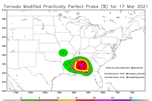
Alabama tornadoes on March 17 indeed favored the intersection of the outflow boundary and a pre-frontal trough approaching. South pre-frontal trough is to Plains dry line. Intersection with outflow boundary (and warm front) are areas of interest.

Big days they both go anyway. Just wanted to tie together a common chase strategy OFBs with the morning rain discussion.
 
other variables like rate of destabilization may be more impactful than just a snap shot of it.

That’s an interesting thought Jeff. Does this suggest that “scenario A” with rapid destabilization can be more favorable than a “scenario B” where the destabilization was in place for a longer time, even if scenarios A and B both have equivalent CAPE when the source of lift arrives?
 
Yes! There seems to be something about the rate of destabilization that is in play.

That’s an interesting thought Jeff. Does this suggest that “scenario A” with rapid destabilization can be more favorable than a “scenario B” where the destabilization was in place for a longer time, even if scenarios A and B both have equivalent CAPE when the source of lift arrives?
 
Mike, your second condition occurred in the early morning hours of April 26,1991 when a nocturnal MCS developed over south central Kansas and north central Oklahoma. This same general area was the focus for severe thunderstorm development later that afternoon that went on to produce four F4/5 tornadoes, with the most noteworthy the Andover storm. The winds seemed more backed in this area as the cold pool rapidly warmed during the afternoon and may have enhanced the low level hodographs with larger helicity values near this mesoscale boundary. I chased that day in north central Oklahoma and remember watching convection rapidly develop to my north in Kansas, but i stayed where I was as the storm movements that day were to the northeast at 30-35 mph and I felt I couldn't catch up to those northern storms. I eventually got situated to watch the Red Rock F4 tornado develop near Billings then move across I-35 and northeast from there. Back in those days, there was no mobil internet/radar displays or cell phones. You made your forecast/target area then watched the sky for clues. This year will be the 30th anniversary of this outbreak.
 
Mike, your second condition occurred in the early morning hours of April 26,1991 when a nocturnal MCS developed over south central Kansas and north central Oklahoma. This same general area was the focus for severe thunderstorm development later that afternoon that went on to produce four F4/5 tornadoes, with the most noteworthy the Andover storm. The winds seemed more backed in this area as the cold pool rapidly warmed during the afternoon and may have enhanced the low level hodographs with larger helicity values near this mesoscale boundary. I chased that day in north central Oklahoma and remember watching convection rapidly develop to my north in Kansas, but i stayed where I was as the storm movements that day were to the northeast at 30-35 mph and I felt I couldn't catch up to those northern storms. I eventually got situated to watch the Red Rock F4 tornado develop near Billings then move across I-35 and northeast from there. Back in those days, there was no mobil internet/radar displays or cell phones. You made your forecast/target area then watched the sky for clues. This year will be the 30th anniversary of this outbreak.

4/26/91 was one of the events that got me interested in severe weather although I didn't experience it firsthand; growing up in the '90s it was the focus of several Weather Channel documentaries such as Enemy Wind and got extensive discussion in Grazulis' The Tornado: Nature's Ultimate Windstorm as well as @Warren Faidley's Storm Chaser: In Pursuit of Untamed Skies (Red Rock was his first tornado if I recall correctly!), among others.
 
We had large hail at our home in northeast Wichita ~7 and the PNC area was under a tornado warning that Friday morning.

NSSFC did a great job that day! Not only did they issue forceful outlooks, they also issued only the second-ever PDS tornado watch. Yet, some local meteorologists seemed -- for a time -- to be mislead by the morning rain.

If memory serves, the sky was completely clear around 10am. The cumulus field didn't redevelop until about noon to 1pm along with a few cirrus.

There are violent tornadoes (Greensburg) that occur without morning rain in threat area but they seem to be a minority.


Mike, your second condition occurred in the early morning hours of April 26,1991 when a nocturnal MCS developed over south central Kansas and north central Oklahoma. This same general area was the focus for severe thunderstorm development later that afternoon that went on to produce four F4/5 tornadoes, with the most noteworthy the Andover storm. The winds seemed more backed in this area as the cold pool rapidly warmed during the afternoon and may have enhanced the low level hodographs with larger helicity values near this mesoscale boundary. I chased that day in north central Oklahoma and remember watching convection rapidly develop to my north in Kansas, but i stayed where I was as the storm movements that day were to the northeast at 30-35 mph and I felt I couldn't catch up to those northern storms. I eventually got situated to watch the Red Rock F4 tornado develop near Billings then move across I-35 and northeast from there. Back in those days, there was no mobil internet/radar displays or cell phones. You made your forecast/target area then watched the sky for clues. This year will be the 30th anniversary of this outbreak.
 
While we certainly have case studies (some peer reviewed) reflecting early day convection in regards to tornado outbreaks/events, I am not overly convinced that early morning convection is always (or even sometimes) truly representative of the possibility or severity of tornadoes. I have experienced both early day convection which preceded tornadoes and experienced many events that were not.
Obviously, I think we all would/could agree that rapid re-destabilization is key. A possible lesser known event that came on the heels post convection is the Tulsa, OK 30 March 2016 event. Early morning convection with severe lasted through much of the day prior to clearing towards central OK and ultimate the DL bulge. Less than roughly two hours after clearing, we had severe and tornado warnings for the Tulsa metro area with a strong tornado hitting the northern side of the metro and adjacent communities.

However, I have experienced/documented many tornadoes that did not have the same type of pre convection environments. I know I have read a few peer reviewed papers regarding the latter (apologies for not locating them and sharing prior to posting) might be interesting and give a little more insight if someone could locate and share accordingly.
-Lanny
 
[1:30am Thursday]

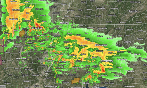
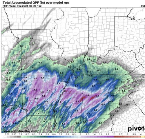
We will have the opportunity to check the observation that morning rain usually precedes violent tornadoes today.

As everyone, I'm sure, knows by now SPC is forecasting a high risk. Radar as of 1:22am shows showers and thunderstorms overspreading the the threatened region. The 05Z HRRR shows significant to heavy rain falling by 17Z over the entire high and moderate risk areas.

Will there be violent tornadoes as SPC is forecasting? If so, it will have rained during the morning hours.

If anyone is going to chase this situation, please be careful. These storms will likely move faster than last week's. The road network plus hills/trees will make it more difficult to chase today's storms.
 

Attachments

  • Screen Shot 2021-03-25 at 1.26.13 AM.png
    Screen Shot 2021-03-25 at 1.26.13 AM.png
    3.7 MB · Views: 0
  • Screen Shot 2021-03-25 at 1.28.19 AM.png
    Screen Shot 2021-03-25 at 1.28.19 AM.png
    1.2 MB · Views: 0
I guess it depends on how you define the coverage then. My understanding is that if, for example, there are 10 tornado reports within the same 40 km grid box, the grid box still only counts for 1.
 
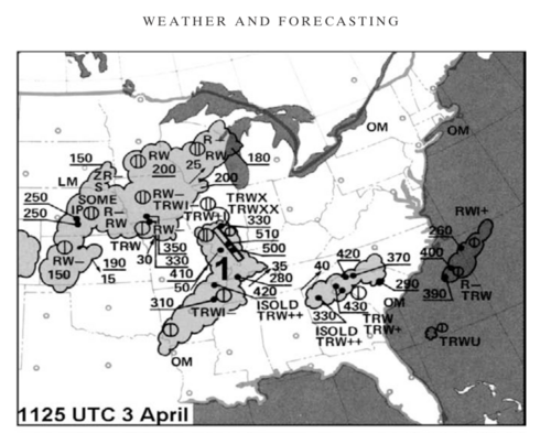
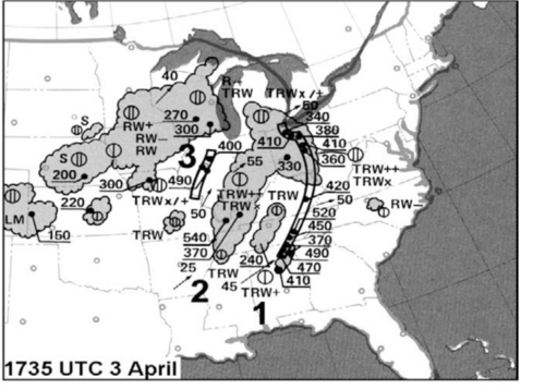
With today being the anniversary of the April 3 outbreak, I wondered if there had been "morning rain." Turns out there was.
 

Attachments

  • Screen Shot 2021-04-03 at 6.52.30 PM.png
    Screen Shot 2021-04-03 at 6.52.30 PM.png
    801.3 KB · Views: 0
  • Screen Shot 2021-04-03 at 6.52.48 PM.png
    Screen Shot 2021-04-03 at 6.52.48 PM.png
    784.6 KB · Views: 0
Back
Top