Paul Markowski at Penn State recently presented a seminar discussing the results of a new paper of his regarding the intrinsic predictability of tornadoes in supercells.
In weather forecasting science, two types of predictability are defined:
Paper link (currently restricted to open access until the 1-year mark has passed, so you'll probably have to check back later): What is the Intrinsic Predictability of Tornadic Supercell Thunderstorms?
Link to the video presentation:
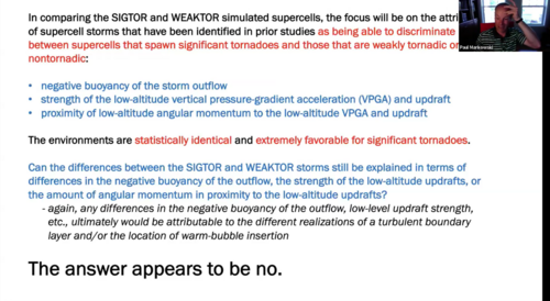
For the TL;DR crowd, this screen cap from late in the presentation kind of summarizes it:

In weather forecasting science, two types of predictability are defined:
- Practical predictability - how well an event can be forecast given the best available technology at the time (in terms of complexity and skill of NWP models, best quality DA system, and a good set of IC and LBCs)
- Intrinsic predictability - the theoretical maximum predictability level given a perfect forecast model and nearly perfect IC/LBCs ("nearly" defined as having errors/perturbations at least an order of magnitude smaller than the values of the meteorological fields themselves)
Paper link (currently restricted to open access until the 1-year mark has passed, so you'll probably have to check back later): What is the Intrinsic Predictability of Tornadic Supercell Thunderstorms?
Paper abstract said:A 25-member ensemble of relatively high-resolution (75-m horizontal grid spacing) numerical simulations of tornadic supercell storms is used to obtain insight on their intrinsic predictability. The storm environments contain large and directionally varying wind shear, particularly in the boundary layer, large convective available potential energy, and a low lifting condensation level. Thus, the environments are extremely favorable for tornadic supercells. Small random temperature perturbations present in the initial conditions trigger turbulence within the boundary layers. The turbulent boundary layers are given 12 h to evolve to a quasi–steady state before storms are initiated via the introduction of a warm bubble. The spatially averaged environments are identical within the ensemble; only the random number seed and/or warm bubble location is varied. All of the simulated storms are long-lived supercells with intense updrafts and strong mesocyclones extending to the lowest model level. Even the storms with the weakest near-surface rotation probably can be regarded as weakly tornadic. However, despite the statistically identical environments, there is considerable divergence in the finescale details of the simulated storms. The intensities of the tornado-like vortices that develop in the simulations range from EF0 to EF3, with large differences in formation time and duration also being exhibited. The simulation differences only can be explained by differences in how the initial warm bubbles and/or storms interact with turbulent boundary layer structures. The results suggest very limited intrinsic predictability with respect to predicting the formation time, duration, and intensity of tornadoes.
Link to the video presentation:
For the TL;DR crowd, this screen cap from late in the presentation kind of summarizes it:

