This will probably be my last post on this thread seeing as we're really getting into the full 2015 season now rather than just discussing the pre-season (although there is still much discussion to be had throughout the season). My outlook for the season is pretty much the same as it was the last time I made a long post on this thread. Little to nothing has changed to make me think this won't be another down year. Given the low numbers so far, I could even see total tornado counts this year being lower than they were in 2014.
The drought situation really has not improved across the southern plains region. In fact, over the last few weeks, more and more D3 is showing up across Oklahoma in particular. The amount of D3-D4 in Texas has also increased a little.

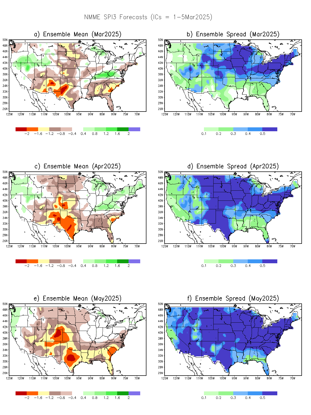
It's good to see there are still both short-term and long-term positive precipitation anomalies across SW TX and S NM, and likely into parts of northern Mexico as well. In fact, some longer-term forecasts call for a continuation of positive SPI values across much of the SW US through the chase season. That may still bode well for the capping situation for later events, but that remains to be seen.

There's been no change to the large positive SST anomalies across the eastern north Pacific. In fact, if anything, the anomalies may have strengthened (http://www.ncdc.noaa.gov/teleconnections/enso/indicators/sea-temp-anom.php). Thus I would expect to see a tendency for west coast ridging to stick around.
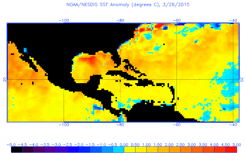
On the other hand, there are some strong positive SST anomalies across the Gulf of Mexico right now. I would think that would be greater potential for evaporation and perhaps the potential for juicier air masses for those periods during which the Gulf truly opens up.

Finally, the CFS is showing some confidence on increased activity starting a week from now. Greg Carbin's graphics page (http://wxvu.net/spc/cfs_scp/) shows several consecutive runs showing many "hot" days coming up early in the first full week of April. It seems most of the CFS forecasts are just noise up until the day 8-12 range, when some coherent signal starts to appear. I'll go out on a limb here and suggest it is picking up on a pattern change that will promote severe weather coming up after another week or so of relatively quiet conditions. After that of course, it's a crap shoot.
Good luck to everyone in their 2015 chases. I finally got to start my season this past Wednesday with the Oklahoma event. Sad that I had to have absolutely no expectations (other than storm formation), but the event actually slightly exceeded those expectations. Hopefully I won't have to hold those expectations down throughout April and May. I may start a sister thread "The Future of the 2015 Season" soon.
The drought situation really has not improved across the southern plains region. In fact, over the last few weeks, more and more D3 is showing up across Oklahoma in particular. The amount of D3-D4 in Texas has also increased a little.

It's good to see there are still both short-term and long-term positive precipitation anomalies across SW TX and S NM, and likely into parts of northern Mexico as well. In fact, some longer-term forecasts call for a continuation of positive SPI values across much of the SW US through the chase season. That may still bode well for the capping situation for later events, but that remains to be seen.

There's been no change to the large positive SST anomalies across the eastern north Pacific. In fact, if anything, the anomalies may have strengthened (http://www.ncdc.noaa.gov/teleconnections/enso/indicators/sea-temp-anom.php). Thus I would expect to see a tendency for west coast ridging to stick around.
On the other hand, there are some strong positive SST anomalies across the Gulf of Mexico right now. I would think that would be greater potential for evaporation and perhaps the potential for juicier air masses for those periods during which the Gulf truly opens up.

Finally, the CFS is showing some confidence on increased activity starting a week from now. Greg Carbin's graphics page (http://wxvu.net/spc/cfs_scp/) shows several consecutive runs showing many "hot" days coming up early in the first full week of April. It seems most of the CFS forecasts are just noise up until the day 8-12 range, when some coherent signal starts to appear. I'll go out on a limb here and suggest it is picking up on a pattern change that will promote severe weather coming up after another week or so of relatively quiet conditions. After that of course, it's a crap shoot.
Good luck to everyone in their 2015 chases. I finally got to start my season this past Wednesday with the Oklahoma event. Sad that I had to have absolutely no expectations (other than storm formation), but the event actually slightly exceeded those expectations. Hopefully I won't have to hold those expectations down throughout April and May. I may start a sister thread "The Future of the 2015 Season" soon.
