State of the chase season 2020

Status
Not open for further replies.
So, what happened?

PDO has finally gone negative which for a long time was chalked up as the big reason we couldn't get a proper central US tornado season for most of the 2010s. ENSO has been hovering cool neutral to weak La Nina although its influence on tornado potential is nebulous (some say La Nina is favorable and point to years like 2008, 2010 and 2011, others say it's unfavorable because it leads to drought).

For most years after 2011 (which wasn't spectacular in the Plains, either) large portions of the spring were wasted to a locked-in unfavorable longwave pattern (either lingering E CONUS trough/Polar Vortex/extended winter; or gigantic death ridge primarily in 2012). In 2019, we got the much-anticipated favorable longwave pattern in the second half of May, but the setups were consistently borked by subtle (unresolvable by models in the medium to long range) synoptic scale quirks that led to issues with initiation timing, storm mode, and capping.

What's it gonna take to get another year like a 1979, 1981, 1991, 1995, 1999, 2003-04, 2008 or 2010? With at least sporadic bursts of activity throughout A/M/J, spread throughout the Plains and Midwest?
 
Next spring the Plains needs a proper TNI Trans Nino Index. The TNI has been shown to correlate better than straight La Nina.

Proper ocean SSTs would be Nina lingers over most of the Tropical Pac. Little warming by South America, but keep the Basin overall Nina.
 
What's it gonna take to get another year like a 1979, 1981, 1991, 1995, 1999, 2003-04, 2008 or 2010? With at least sporadic bursts of activity throughout A/M/J, spread throughout the Plains and Midwest?

When I first read that sentence my thought was to look at when I started chasing (1996) and count the good years listed - and felt disgusted that there were only 5, out of 20+ years of chasing.

But the 20 year span from 1979-1999 also only has 5. So is it no worse than it's ever been, and it's only our collective impression based on recency bias? Or is it just that, yeah, there's always only 5 great years out of every 20, but the 1979-1999 span still had many more decent seasons than 2000-2020 span? I don't know enough about the 1979-1999 stretch to answer that.
 
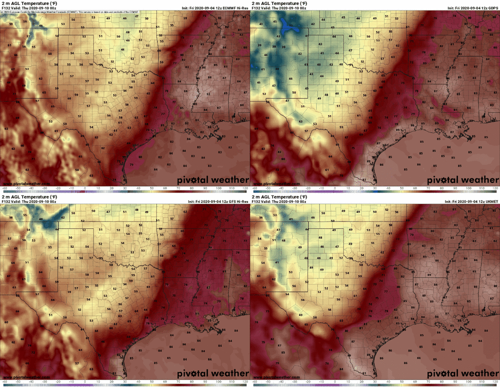
The consensus NWP forecast for OKC's temperature at 7pm next Wednesday is currently around 50 F, including a 48 F vote from the ECMWF.

models-2020090412-f132.sfct.us_sc.gif

Meanwhile, the record cold high for the date is 67 F, based on over 120 years of records. If it were occurring one day earlier, the record to beat would be 73 F. If the guidance is even in the right ballpark, this record will be shattered by a margin of 10-15 F.

While purely anecdotal, it is remarkable how often lately, despite the background of a warming global climate, we have seen truly anomalous cold during the warmer portions of the transition seasons in the central U.S. This has certainly been a common anecdotal complaint in our commiseration threads the past few years. I believe the CO contingent has been especially vocal about this, and they may be about to see a disruptive snowstorm at Denver's elevation before September 10.

It's so early in the fall that there's theoretically plenty of time for moisture recovery and a pattern change prior to the late September-mid October timeframe, the historical peak for second season setups in NE/KS/OK/TX. Regardless, it's depressingly stunning how easy it's been to come by big anomalies (whether synoptic or seasonal in time scale) that work against us.
 
While purely anecdotal, it is remarkable how often lately, despite the background of a warming global climate, we have seen truly anomalous cold during the warmer portions of the transition seasons in the central U.S. This has certainly been a common anecdotal complaint in our commiseration threads the past few years. I believe the CO contingent has been especially vocal about this, and they may be about to see a disruptive snowstorm at Denver's elevation before September 10.

I hope this is not too far off topic, but there are several research articles that conclude a warming earth, particularly the Arctic, leads to a "wavier" jet. I would conclude that based on those findings, we would experience more frequent, anomalous weather swings like one forecast this upcoming week, and I would also think that would generally be more favorable for severe setups over time, but that really hasn't been the case...

I know that it takes more than an active jet to produce an ideal setup, but you'd think things would fall into place more than they have been. Either it's just a streak of "bad luck", or there's something bigger afoot, as has been alluded to in other threads and earlier in this one, I think.
 
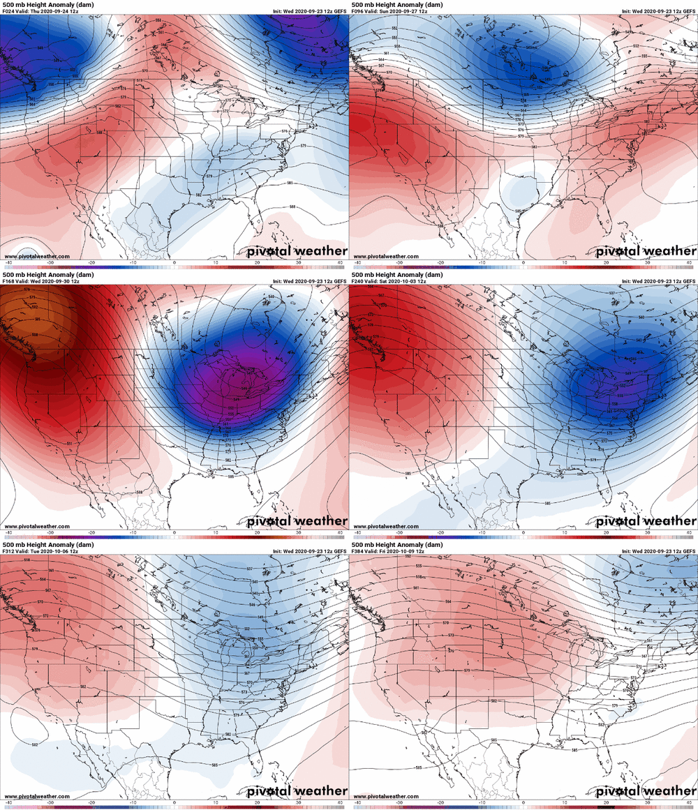
The broad consensus I have seen on various listservs and on social media is that this upcoming pattern shift is largely the result of Rossby wave amplification resulting from the extratropical transition of one or two Pacific tropical cyclones. As soon as their "energy" is "absorbed/used" the pattern appears to settle back down somewhat. In fact, I wouldn't be at all surprised to see a return to the existing dominant summertime pattern two weeks from now.

So this seems to be more of a chance event rather than a sense of a longer-term signal.
 
I believe the synoptic pattern that led to the November 2013 tornado outbreak was partly attributed to the recurvature of a WPAC typhoon (possibly the infamous Haiyan). Obviously this setup isn't expected to lead to anything like that. Haiyan also tracked much further south than Haishen is, striking the Philippines/Vietnam rather than Japan/Korea.
 
Not a whole lot to like about heading into winter with a spatially expansive western drought and enso drifting back into a weak nina, neither of which seem to bode well for the following plains season. Years that headed into the winter with these conditions were overwhelmingly poor(notable examples from the past decade include 2018, 2014, 2012, and 2017 to an extent) and do not have me optimistic for good plains activity in 2021. Weak ninas seem to favor BA plains activity in general, whether or not drought is present during the preceding winter. This is the earliest I think I've ever really talked about an upcoming season and as such, this is a very obtuse analysis that is barely scientific, but something I thought might be worth sharing regardless.

Those are the key features I'm watching over the winter. How the nina evolves(where I think a stronger nina probably ends up being better in general) and the extent of the drought. My guess is that due to the nina, no matter it's strength, the current expansive drought struggles to weaken and probably expands markedly, but who knows.
Agreed. There have been quite a few years with weakly to moderately cool ENSO during the winter-spring timeframe since 2000, and they have largely been bad news. Of course, some possibility of a stronger La Nina remains, which would probably be preferable. Unfortunately, I agree that drought is likely to persist and potentially expand across the southern and central Plains during the cool season, tipping the scales in favor of 2021 being an I-35 type of chase season on the Plains.
 
On top of this, the global models suggest this odd pattern will displace / weaken the Atlantic high and keep the current batch of waves (or eventually tropical storms) away from US coastlines for at least the next 10+ days. It's only a guess, but most of September could see a much lower tropical threat that originally forecast.
 
Later this week looked possible Mid South a couple days ago. That mid-latitude trough is pretty much DOA now. Maybe IA/IL but too far.

Following week to 10 days those in Dixie could hope for recurving TCs, but if they form that deep in the Atlantic, plenty of chances to get caught by a trough before approaching. After mid-September climo strongly drops Western Gulf, and Dixie TC remnants.

La Nina (alone) has a poor correlation with spring severe. However the TNI Trans Nino Index has shown promise. If the Central Tropical Pac stays cool but right near South America starts to warm, it is a +TNI and somewhat correlated with AN severe.

Given the current and forecast long-wave patterns I've become pretty bearish 2020 fall, until deep winter Deep South. That's junk, so yeah I'm desperately grasping for things like TNI next spring.

Sorry for the unusually bearish post. At least sports is back!
 
Status
Not open for further replies.
Back
Top