Matt Zumbrunn
EF2
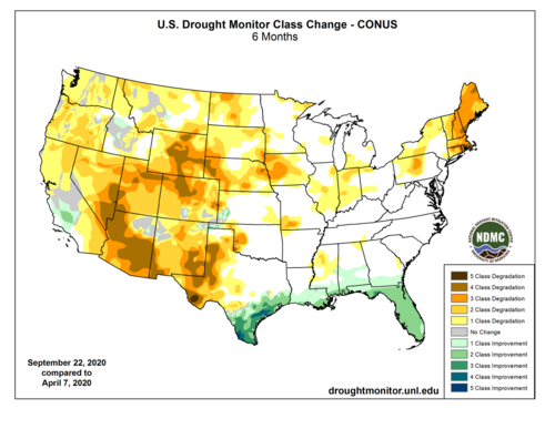
I thought about this thread today. Looking about 2 weeks out 70s and 80s with zero chances of rain. We are pretty dry for not being on the drought monotor.


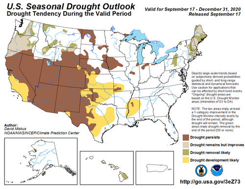
Well said, and I fully agree. It's hard to fathom how bad things are on all fronts every time I check back in. The new rule seems to be All Bad All The Time And Nothing Ever Gets Better Ever. With virtually no hope of even a passing 5% moisture-starved fall Plains setup this year, we careen into what will quite possibly rival 2011-2014 for cold season drought. Meanwhile, historic wildfires are charging through the Denver/Boulder area this evening and probably threatening a few chasers' homes -- and we're midway through October with La Nina upcoming. Suffocating smoke overspreading half the continent has become passé, and as you alluded to, skiing will probably suck south of the Canadian border area this winter (not to say it will be safe anyway for non-locals needing to fly in). I'm trying to imagine what a year as good as this one is bad would look like, but that's likely impossible.As a storm chaser, a skier, and a resident of southwest Colorado worried about drought and wildfires, I find this forecast scary on every front. Regarding chasing, although La Nina can sometimes be good, this much warmth and drought in the southern Rockies and southern Plains does not portend a good season next year, unless you live or can easily chase somewhere between Wyoming and Minnesota. Farther south, that much prolonged drought, after a dry late winter and mostly non-existent monsoon this year, will be hard to overcome. And in the Four Corners states and westward, it looks very bleak from a water supply, wildfire, and ski season standpoint. I am very worried about what next year's wildfire season will bring everywhere from California eastward to Colorado and New Mexico. And maybe the southern Plains, too.
From the Wichita NWS facebook page.
View attachment 21009
I was looking at this post, and, honestly not sure exactly where the 23 number came from (but, since they labeled it as prelimary, they met be using the unfiltered numbers from the SPC collection of LSRs from their clinic page.
However, the numbers for the Mount Holly CWA were not insignificant this year. Using Stormdata (i.e., the official numbers), I see thirteen 2020 tornadoes through 8/31/2020 (I think the official numbers are updated quarterly, right?). The first one occurred on 2/7/2020 in Cecil County, MD (and, the damage survey on 2/8 was done with light snow/flurries falling). Two tornadoes occurred in April (1 in MD, 1 in NJ). 8 occurred on August 4 associated with Isaias, affecting MD, DE, NJ, PA (Mount Holly covers all of DE, plus portions of MD, PA, NJ). Another tornado occurred on 8/7 near Wilmington, DE. And another tornado occurred on 8/19 in NJ.
Not yet in Stormdata are two EF0 tornadoes that occurred on 11/30 (one in PA and one in MD). There was a third, also in MD ... in Cecil County ... Cecil County was recently removed from the Mount Holly CWA and added to the Baltimore/Washington CWA.
The strongest tornadoes were EF2 during Isaias (one started in NE Philadelphia and tracked to Doylestown, doing damage to the Doylestown Hospital and an adjacent day care center).
The Isaias tornadoes and also the 11/30 tornadoes were moving at 50 mph or faster, so, chasing them in this area would have been quite a challenge. As is often the case, chasing in "lower slower" Delaware was probably the best chance of success.
