Andrea Griffa
EF5
If someone doesn't remember, June 4th 2005 was the day of the HIAWATHA tornado in Brown County KS.
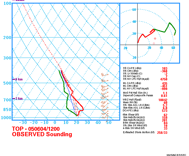
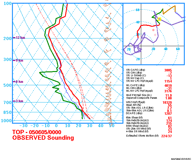
That day was characterized by an early convective development (21.30 Z) that didn't take to an isolated supercell development; if I remember right SPC outlook showed an high risk of severe thunderstorms for East KS, extreme SE part of NE and, NW MO, and SW Iowa.
Synoptic situation showed a short wave trough on W Nebraska with a strong mid level flow from S-SW on eastern part of Kansas.
http://www.spc.noaa.gov/exper/archive/even...4/500-oa-00.gif
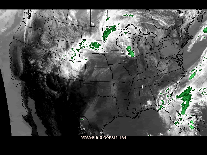
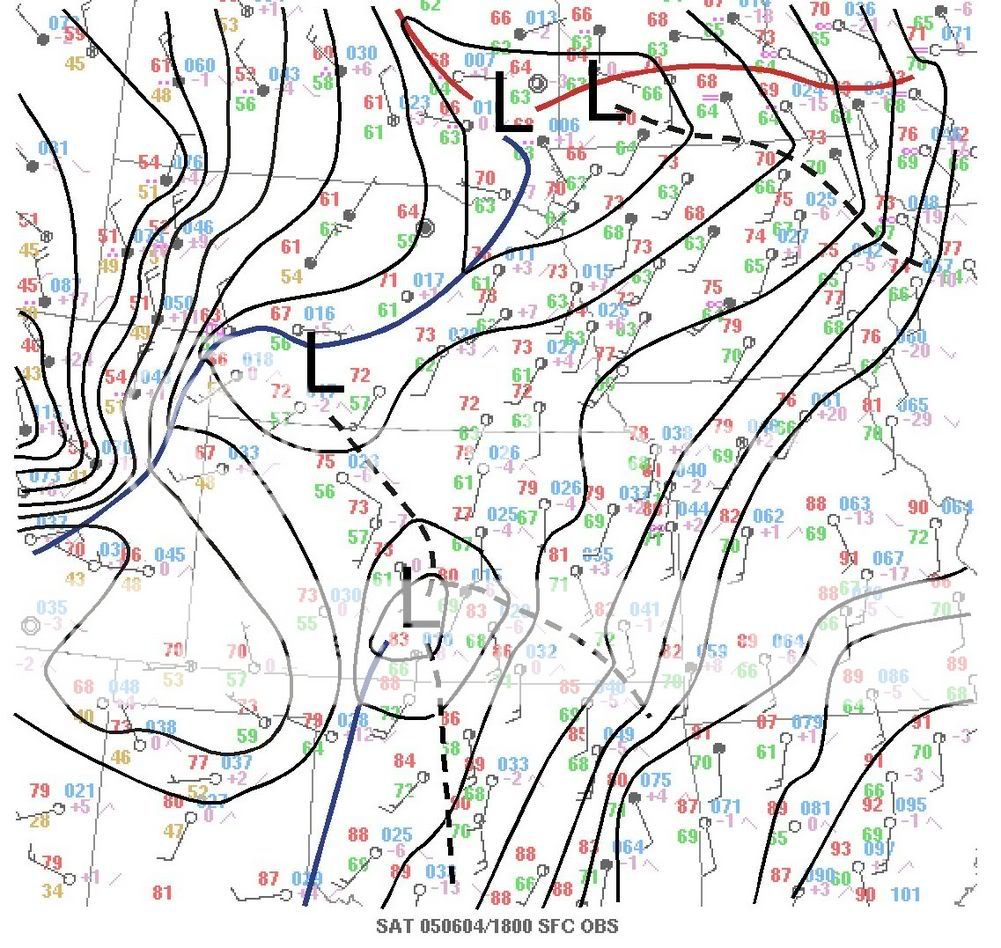
At the ground, there was a low pressure system with the low put down in central Nebraska associated with a cold front extending from S-central NE till central KS and Ok panhandle.
http://www.spc.noaa.gov/exper/archive/even.../hpc-sfc-00.gif
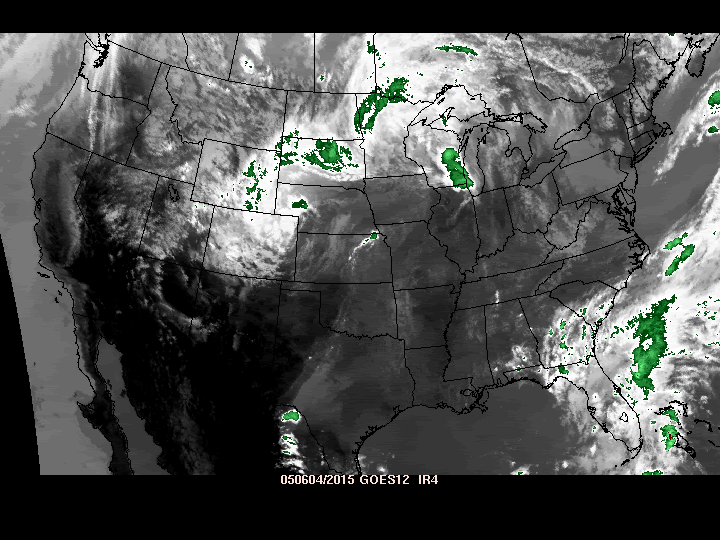
At 21Z convection started in NE Kansas and a tornadic supercell rapidly developed in Brown county and at 21.20 and 21.30 two tornado were in the ground in Hiawatha.
But as rapidly brown county supercell developed, the other supercells in the lines merged and didn't permit an isolated supercell development leading to a bow echo and lewp development.
http://www.spc.noaa.gov/exper/archive/even...50604/rad18.gif
http://www.spc.noaa.gov/exper/archive/even...50604/rad24.gif
So wich are the causes of the lack of the isolated supercell development? As to me they have to be researched in the wind shear and the orientation of the boundary. BL-6km vector is nearly parallel with the orientation of the cold front. Thermodynamic setup was very good for a tornadic outbreak so I don't consider that.
Anyone has got an idea? Let's discuss about the case.
That day was characterized by an early convective development (21.30 Z) that didn't take to an isolated supercell development; if I remember right SPC outlook showed an high risk of severe thunderstorms for East KS, extreme SE part of NE and, NW MO, and SW Iowa.
Synoptic situation showed a short wave trough on W Nebraska with a strong mid level flow from S-SW on eastern part of Kansas.
http://www.spc.noaa.gov/exper/archive/even...4/500-oa-00.gif
At the ground, there was a low pressure system with the low put down in central Nebraska associated with a cold front extending from S-central NE till central KS and Ok panhandle.
http://www.spc.noaa.gov/exper/archive/even.../hpc-sfc-00.gif
At 21Z convection started in NE Kansas and a tornadic supercell rapidly developed in Brown county and at 21.20 and 21.30 two tornado were in the ground in Hiawatha.
But as rapidly brown county supercell developed, the other supercells in the lines merged and didn't permit an isolated supercell development leading to a bow echo and lewp development.
http://www.spc.noaa.gov/exper/archive/even...50604/rad18.gif
http://www.spc.noaa.gov/exper/archive/even...50604/rad24.gif
So wich are the causes of the lack of the isolated supercell development? As to me they have to be researched in the wind shear and the orientation of the boundary. BL-6km vector is nearly parallel with the orientation of the cold front. Thermodynamic setup was very good for a tornadic outbreak so I don't consider that.
Anyone has got an idea? Let's discuss about the case.