Hurricane Beryl

Beryl has to be getting up there compared to other hurricanes in the number of tornadoes it produced. Now up to 29 in the Shreveport, LA CWA alone. And cumulatively many others in the Houston, Little Rock, Paducah, and Buffalo CWAs, among others. Not sure what the total is but I would be shocked if it is less than 40, probably more, and there are still surveys ongoing in some areas.
 
I'm curious to know the final count, too. Some tropical systems (and extratropical ones) rack up substantial tornado counts, and others just don't. And there's no simple or pat explanation as to why or why not. (Almost 20 years ago, Ivan set a rather high bar at 118 tornadoes.)
 
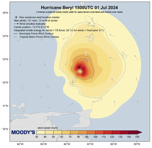
The image shows 1-minute, sustained-windspeed estimates of Beryl at landfall in the Windward Islands.
Essentially, we see Hurricane Beryl's "footprint" of maximum winds, and the areal distribution of both hurricane & tropical-storm winds.
The point being something that NHC also realizes...size of these fields matters for wind and surge damage potential, not merely cat-numbers.
From a chasing perspective, such a mindset matters when you're trying to get to the eye wall and get photos of the stadium effect inside. Image.jpg
 
Total for tornadoes from Beryl is now up to 65. Not final number yet. We have to wait about 3 months for the finalized reports from each WFO that get sent to NCEI.

Beryl is the 5th most prolific TC tornado producer on record, with the usual caveats about how detection and documentation of tornadoes in general have become much, much better in just the last 30 years alone.
 
...Beryl's EF-3 tornado in Mt Vernon, IN...
If getting an EF-3 from the remnants of a tropical cyclone seemed a bit surprising, strong, and sort of rare... it was.
From what I can tell, and depending on periods of record, the likelihood looks to be somewhere between < 1 % to about 4%.
NWS Paducah says it set the bar for the strongest, July tornado in their county warning area. A real attention-getter, I'd say.
 
Beryl earned a lot of superlatives. But, let's call this "looks can be deceiving," or "how was Beryl perhaps not so amazing?"
In the Norcross' book about Hurricane Andrew, he mentions 8 miles made huge differences as he assessed wind damages in greater Miami.
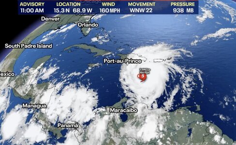
So on July 2, Fox posted a visible satellite image of top-ranked Beryl. And they pointed out some common facts, including...
* Hurricane-force winds extended outward 40 miles from the center.* I thought about that.
Look at the apparent size of this storm with winds likely over 150mph. Yet, just 40 miles out from the middle, the winds blew only half as fast.
Forty miles out, tropical-storm strength winds ruled, less than 74mph. (Still, I would have to call that one tightly-clenched fist!)

Screenshot 2024-07-22 at 2.17.42 PM.jpeg
 
Back
Top