Hurricane Irma 2017

I'm seeing pictures on Twitter right now of a reverse or "anti" storm surge of water rushing OUT to sea in Tampa and Naples.... it looks very similar to what happens right before a tsunami hits. Of course the water is going to come back with a vengeance at some point. How often does this happen ahead of a hurricane and how bad an omen is it for the strength of the eventual surge?
 
I'm seeing pictures on Twitter right now of a reverse or "anti" storm surge of water rushing OUT to sea in Tampa and Naples.... it looks very similar to what happens right before a tsunami hits. Of course the water is going to come back with a vengeance at some point. How often does this happen ahead of a hurricane and how bad an omen is it for the strength of the eventual surge?

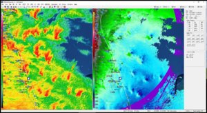
Yeah I wonder if the surge will just bring the water back to where it was, as opposed to exceeding the normal tidal zone... Also the surge was supposed to be the worst when the eye moved north and the wind shifted to onshore - but the southern side of the hurricane looks like it is weakening significantly, and judging from live coverage from Naples it doesn't look like there's much in that southern eyewall...


Sent from my iPad using Tapatalk
 
Real life and death, battle royal going on between the GFS and ECMWF over where Irma will end-up. From reading NHC discussions, I believe they are thinking strong high pressure will win out and Irma will keep moving west. The ECMWF has it pounding Key West then moving it into the Gulf a week from this Sunday.

On the other hand, the GFS and most tropical models are currently taking it into the Long Island region during the same time frame. There has been some westward adjustments over the last few GFS runs so it will be interesting when the models jell and emergency management can start planning.

No matter what the outcome, it appears that another major hurricane will impact the US coastline in the next 10-12 days. Oh, and another wave just came off the African coast!
Any thoughts on the Atlantic Nino(or Nina) that is spawning these storms ? How does the state of the Atlantic Nino mode correlate with these storms ? The public only knows and hears about ENSO and the Atlantic mode is hardly discussed and yet here we are two of the most destructive cyclones in history thanks to the current state of the Atlantic ocean(Ocean + Atmosphere)
 
Last edited by a moderator:
Hi everyone! First timer here!
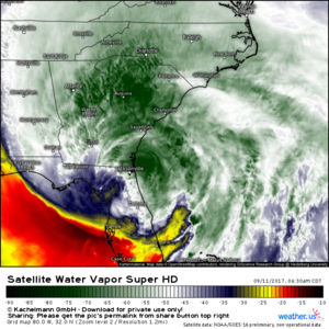
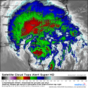
Been watching Irma for days and am SO glad this storm wobbled towards Cuba then wobbled to the east when making landfall. This could have been sooooo much worse! This morning, upper level outflow and dynamics associated with the jet streak to Irma's north (PRE) are now dominating the system as the inner core evaporates approaching Jacksonville. It's amazing to watch! Loop: https://weather.us/satellite/800-w-320-n/top-alert-superhd-15min.html#play
 

Attachments

  • us_sat-en-087-0_2017_09_11_08_45_5750_486.png
    us_sat-en-087-0_2017_09_11_08_45_5750_486.png
    801.4 KB · Views: 1
From news reports this morning it sounds like the southwest coast didn't get quite the level of surge expected. Is that because of the pre blowout tides / "reverse surge" from the offshore wind? And/or because the onshore winds in the southern eyewall weren't as strong? There didn't seem to be much left to the southern eyewall the whole day, and even just watching live coverage from Naples you never saw much wind return after the eye had passed.


Sent from my iPad using Tapatalk
SW coast didn't get the surge quite as bad due to the weaker nature of the storm as well as the track slightly to the east. If the center tracked offshore, those 130 mph offshore winds observed in Naples and at Marco would've been much more onshore and then you would've been in big trouble. Weakening due to Cuba also played a part.. Weakening Cat 3 =/= steady Cat 4/5. It was bad for many areas, but nowhere near as bad as it could've been!
 
Lower surge west was 100% due to the track. Saffir-Simpson scale is obsolete. Irma ACE number remained exceptional. East coast of Florida had impressive (a couple records) surge considering landfall was on another coast!
 
Lower surge west was 100% due to the track. Saffir-Simpson scale is obsolete. Irma ACE number remained exceptional. East coast of Florida had impressive (a couple records) surge considering landfall was on another coast!


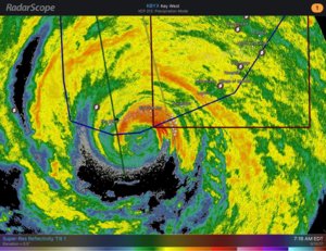
IDK, do you really think the lower surge on the west coast of FL was only due to the track? The track really wasn't all that different than forecast within the last 24 hours that it was affecting FL. The surge forecasts were high even when it was known the hurricane would be along the west coast, meaning it would have to be driven by the southern eyewall which would bring the onshore flow. But at least based on radar, the southern eyewall was already eroding at 7:15 in the morning while Irma was still in the Keys.

4dbf8088af9c9ba4fc0965fbe76c6997.jpg
 
IDK, do you really think the lower surge on the west coast of FL was only due to the track? The track really wasn't all that different than forecast within the last 24 hours that it was affecting FL. The surge forecasts were high even when it was known the hurricane would be along the west coast, meaning it would have to be driven by the southern eyewall which would bring the onshore flow. But at least based on radar, the southern eyewall was already eroding at 7:15 in the morning while Irma was still in the Keys.

View attachment 16374
Track was a significant player in the lack of surge in Tampa/Ft Meyers area. Onshore track to the east of those cities prevented RFQ surge and the earlier landfall helped accelerate weakening of southern eyewall. Furthermore, this would me a MUCH different conversation had it not been for the track wobble into Cuba. Was it 100% track? No, dry air and shear played a part, but it was probably >95% track :)
 
Track was a significant player in the lack of surge in Tampa/Ft Meyers area. Onshore track to the east of those cities prevented RFQ surge and the earlier landfall helped accelerate weakening of southern eyewall. Furthermore, this would me a MUCH different conversation had it not been for the track wobble into Cuba. Was it 100% track? No, dry air and shear played a part, but it was probably >95% track :)


I agree with respect to Tampa and Fort Meyers. But some of the highest surge was forecast on the southwestern coast, south of Naples. The hurricane was forecast to be offshore at that latitude, and it was in fact still offshore. Even the right front quadrant would have produced more of an offshore wind at that location, so it had to be the onshore flow in the southern eyewall that was expected to produce the surge, and I think that southern eyewall had weakened considerably.

Not trying to be argumentative, obviously there are a ton of variables in the mix. I am mainly trying to understand if my theory is correct and if the southern eyewall did in fact weaken, because I can only go on the weakened radar reflectivity image that I saved and posted above. I realize this doesn't necessarily mean that the winds had also weakened, so that's what I am trying to find out, how much of a factor was it. By the time the hurricane had passed north of the Keys, there were no more surface wind observations coming from that station so I don't know what the winds in the southern eyewall were like. But I did notice from live reporting from Naples that after the eye had passed there wasn't much wind blowing at all.


Sent from my iPhone using Tapatalk
 
Unless you have a death wish. Stay away from Key West if Irma's path or core heads that way. Highway 1 is a death trap. There are places where the ocean is literally lapping at the edges of the highway. I remember telling Jim Leonard that one of my worse fears was to be trapped on that highway -- and it's a very long road, about 160 miles from Miami. Just thought I'd throw this out in case someone was considering it.

Stay safe.


Warren, just wondering about the results of your chase, in an early post you said you were heading to someplace in FL, I can't remember where but I'm sure your initial target changed anyway.

Apparently there were chasers in Key West at some sturdy "concrete hotel of at 7 (?) stories built in 1926." I also learned that Key West has an 18 foot elevation but I'm not sure how much of the island is at that elevation. Would you have considered that scenario safe or do you think Key West turned out OK only because the right front quadrant missed the island? I might actually consider trying a Key West intercept in the future if there is an opportunity. There were also chasers in Big Pine Key, now THAT seems suicidal to me but then again I don't know too much about that particular island...


Sent from my iPhone using Tapatalk
 
Back
Top