09/26/2024 - Hurricane Helene

Surprised to see some business signage apparently still intact in Perry per chaser videos/photos. Those usually are some of the first things to go in a hurricane, most are blown out after the first eyewall pass in even a Cat 1/2. Highest gust on an ASOS/AWOS was 99mph at the Perry station.
I've noticed this in the past, too. A hurricane-hunter airplane flies around trying to get the highest windspeed they can most anywhere aloft in the storm. Assumptions are then made about what the winds might translate to at the surface, of course.
But, the reality of how the winds actually mix down in various conditions, how fast they blow at the surface at differing locations ends up another story. So yeh, a big difference often exists between land-based anemometer readings and the conversions from flight, unfortunately.
 
Last edited:
Now see this is why I always say hurricane chasing logistics perplex me. Obviously people do it, but it seems intractable to me.
And I can't imagine that I'm the only one unimpressed by night-time video of wind & rain nearby a hotel or on the road during Helene. 🤔
I've got my opinions, sure, but there was no daylight, no visible eyewall, and a whole lot of similar content that's....well, not so great.
 
Last edited:
And I can't imagine that I'm the only one unimpressed by night-time video of wind & rain nearby a hotel or on the road during Helene. 🤔
I've got my opinions, sure, but there was no daylight, no visible eyewall, and a whole lot of similar content that's....well, not so great.
Completely agree, in fact I logged on here just to see if I was not alone in my assessment of the storm. Even post storm drone footage was nothing like any Cat 4 or even Cat 3 storm damage I've seen. And Ive been in Cat 2s that looked a lot windier than the footage from Perry.
The eye was very wide and somewhat ragged coming in. Not surprisingly, the big story has been the flooding.
 
Unfortunately the flooding event is verifying in the southern Blue Ridge in historic fashion. Some absolutely crazy reports coming out of those areas:


I almost drove to Lexington, Kentucky today for the 70mph gusts models showed still present from the TD / gradient wind event. Decided to wait here at home as we should see close to TS conditions upwards of 50-60mph gusts just to our east tonight. A 4 hour tropical night chase sure beats a 3-4 day one! Night video of anything performs poorly on just about any outlet.
 
The only time I was ever able to even think about chasing a hurricane (aside from local east coast “brush-by’s”) was Ian in 2023. I called various hotels in Florida and they all told me that they were either in evacuation zones so I wouldn’t be able to make a reservation, or they were booked with people who apparently are able to make advanced arrangement to use the hotel as a shelter f their homes are evacuated.
 
The situation in western North Carolina is truly a mega-disaster on the scale we haven't seen in the US since Katrina. It's not hyperbolic to compare Asheville's plight right now to New Orleans in Katrina. The infrastructure of all types (housing, commercial, transportation, utilities) has been decimated and we're not even getting a fraction of a picture of all of the impacts and casualties. I chased many flash flood events in West Virginia. Just *2 to 3 inches* of rain causes serious flash flooding in that type of terrain.

James, I think that the typical trip planning might not yield good results for a hurricane chase. A hotel might accept an in-person check-in a couple of days before landfall but would likely turn away anyone trying to reserve a room via phone or online. When I stayed in hotels in Florida before Frances, there was only one person there at the desk, all of the other staff was gone. At the second one, there was a sign on the desk saying that there would be no staff soon and anyone staying there would be on their own. I feel like I probably would have been turned away if I'd have called them beforehand to reserve a room.
 
A few quick points. I thought the forecasts for heavy rains during Helene in the Appalachians were quite good. Also, whether you're in the tropical weather naturally by living there or coming from somewhere else to chase it, it's a lesson in inconvenience.
Just how willing is a person to sleep in their vehicle? And how much devastation and suffering can a person take before it affects them?
Post-traumatic stress is a real thing. One of my students came home after Katrina to to find his mother pinned behind a refrigerator. Unfortunately, FEMA had put a symbol on the door saying no deaths there, so he got badly surprised when that wasn't true.
We all can think about these things, and we do feel for the people and places after events like Helene, but it's hard to truly understand and grasp until you're in it or it happens to you or your town.
 
Completely agree, in fact I logged on here just to see if I was not alone in my assessment of the storm. Even post storm drone footage was nothing like any Cat 4 or even Cat 3 storm damage I've seen. And Ive been in Cat 2s that looked a lot windier than the footage from Perry.
The eye was very wide and somewhat ragged coming in. Not surprisingly, the big story has been the flooding.
A DOW in Perry FL record a peak gust of 104 mph on its mast. Its mast is 18 m high. Give how strong Helene was and how fast it was moving, I am surprised this was their peak gust, and it was above the standard 10 m level for wind measurements. Sustained winds drop off rapidly even a few miles inland, but gusts can easily still remain very high farther, as strong as what is experience at the coast.

The thing is 938 mb for a pressure is nothing to shake a stick at. That supports strong Cat 3 low/end Cat 4. Although Helene's eye did not have a closed ring on radar before landfall. It was the classic "half-moon" semi-circle we so so many times with hurricanes accelerating N due to strong baroclinic influence. Dry air wrapping around in from the S&W erodes the eyewall.

Also, has anyone seen any reports of the max storm surge in FL? Highest I have seen is about 10 ft, but where Helene made landfall, the coast is low population all the way to about 30 mi N of Tampa.
 
...reports of the max storm surge in FL? Highest I have seen is about 10 ft...
Storm surveys might reveal the reality of storm-surge heights says TWC. (Modeling showed ~ 15 ft.)
Image 2.jpeg
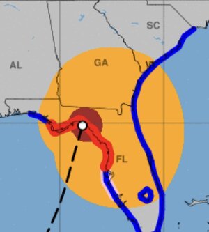
Also above, yellow shows tropical-storm force winds, red for hurricane strength on 9-26-'24 at 11 p.m. EDT for Helene (NHC).
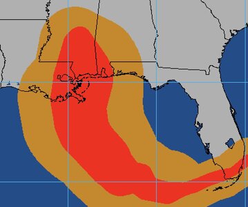
Just for rough comparison, Katrina's 2005 path in August for those two wind categories is shown in orange and red below.
Image 1.jpeg
 
Back
Top