-
While Stormtrack has discontinued its hosting of SpotterNetwork support on the forums, keep in mind that support for SpotterNetwork issues is available by emailing [email protected].
You are using an out of date browser. It may not display this or other websites correctly.
You should upgrade or use an alternative browser.
You should upgrade or use an alternative browser.
Hurricane Irma 2017
- Thread starter Warren Faidley
- Start date
Warren Faidley
Supporter
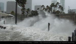
Wild chase considering the last few hours of drama over where Irma would go. Could write volumes about the last week. The eastern coast was still my target -- despite a lot of media people blasting off Friday night to head west. I surmised the accumulated surge momentum would still effect the east coast. The biggest surprise was wind. It will be interesting to study the wind reports in the Miami area. I could not stand for long periods of time as the wind was simply too strong to work in. Debris from skyscrapers was a constant threat. The was wind coming directly off the water, not compressed winds through structures. I saw at least two strong vortices move in from the east. The first struck me on the walkway next to the bay and nearly carried me into the water after forcing me to slide on the concrete for about 10 feet. It took out a fortified glass and brick partition behind me. I ended up with some cuts but overall, I was extremely lucky. Got some great footage, which I never expected after Irma kept heading west. I spend the rest of the evening and the next morning checking the area for victims. Fortunately, the only thing I found was a small puffer fish washed ashore and gasping for water. I put it in the water and it swam away. I figured I owed Neptune a favor.

Rob Wadsworth
EF5
Anyone have any useful/interesting links to the coastal erosion caused by the surge?
Warren Faidley
Supporter
FEMA always posts (open to the public) satellite images of post-storm surge and erosion damage for rescue and recovery operations. I saw images covering portions of western Florida and especially the keys. I don't have a link, but it's an easy Internet search.
Jeff Wright
EF4
- Joined
- Apr 23, 2010
- Messages
- 406
I thought I heard that Irma may wind up merging with Jose...
rdale
EF5
I thought I heard that Irma may wind up merging with Jose...
Irma died near St Louis Missouri.
Jeff Wright
EF4
- Joined
- Apr 23, 2010
- Messages
- 406
That's right...starting to lose track Maria and Jose then.
Alex Elmore
EF2
That's right...starting to lose track Maria and Jose then.
I don't think there's enough left of Jose to merge with now, let alone when Maria catches it.
cdcollura
EF5
Good day all,
This is my chase log for hurricane Irma in SW Florida. Details are below...
Summary: This area shows pictures taken from the interception and observation of powerful category-four hurricane Irma in southwestern Florida mainly during its landfall in Marco Island and into Naples (Collier County). Hurricane Irma was a deadly and powerful hurricane that made its way across the Atlantic from the Cape Verde Islands off Africa in the first days of September 2017. Reaching category 5 strength, with 185 MPH winds, the storm devastated the northern Virgin Islands, passing north of Puerto Rico, then into the southeastern Bahamas. On September 9, the storm scraped across the northern Cuban coast as a category 5 storm with 160 MPH winds, then turned north and passed east of Key West with 140 MPH winds early on September 10. Later that same day, the storm made its final landfall as a strong category 3 / minimal category 4 with 125 to 130 MPH sustained winds at Marco Island. Steadily weakening thereafter, Irma continued north through Naples and east of Fort Meyers, becoming a tropical storm early on September 11 in northern Florida and Georgia. Irma finally met its end to a destructive 13-day long route from west of Africa (around Aug 30) to the USA as it became a tropical depression and dissipated over the SE USA on September 12. Irma caused extensive damage (and even catastrophic) during its journey, with several landfalls (Barbuda and British Virgin Islands, Cuba, and Florida). This chase was a "local" chase in Florida, with chaser Derek Sibley joining me. We headed out of my area in Broward County and targeted the SW Florida coast for the September 10 landfall, which would be during mid-day and ideal. We stayed at storm chaser Mark Farmer's place in Naples, helping him with boarding up and such, and joined Brett Adair, Caleb Elliott, and many other chasers (who were also in TX in Harvey) at the American Sports Pub (only place open on Sept 9) for a pre-chase party. For the interception, we chose a parking garage at a beach-front resort early on September 10, on the southern tip of Marco Island (buildings there rated for category 5 winds). The eyewall and calm eye of Irma was experienced at this location. After the storm, we went back out and worked our way out of Marco Island, observing extreme flooding and some storm surge. After checking if Mark Farmer was OK (he stayed in Naples), we left Naples and headed back east to my place in Broward County. Power was out at my place for several days, and tree damage and some roofing tiles missing. The total mileage was 292 miles.
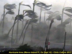
This is a picture taken from inside the inner eyewall of hurricane "Irma" as it was making landfall in Marco Island, Florida at roughly 3:15 PM EDT on September 11, 2017. The ferocious winds here are blowing with gusts exceeding 130 MPH, tearing apart palm trees, throwing debris across the area, and nearly tearing my shirt right off my body. This scene was lit by a brilliant flash of lightning and thunderclap barely audible over the roar of the wind. This was about 10 minutes before entering the calm eye of Irma (which had some sun peeking through).
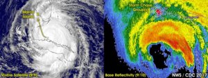
These are two annotated images showing hurricane Irma as it made its final approach and landfall in the Florida Keys and into southwest Florida. The left image is a visible satellite image as the hurricane moving along the northern Cuban coast as a borderline category 5 hurricane late on September 9. The yellow arrow shows how the storm was to turn north, cross the lower Florida Keys, and move into the southwest Florida coast. To the right is a radar image (reflectivity) as the hurricane core was approaching Marco Island with winds at least 130 MPH. The eyewall is slightly eroded on the south side due to some dry air drawn into the "moat" region between the concentric eyewalls. The northern eyewall is where there is violent rain and also contains all the wind dynamics. The convective "chimney" of the storms right-front eyewall is the red region. To the north of the calm eye and hurricane core, numerous chasers (from Spotter Network) appear in Marco Island as red dots. The cross-hairs is my GPS location at the time.
Full video of Hurricane Irma is below...
Pictures are below...
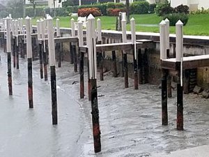
Above: During the morning of September 10, from Naples and into Marco Island, the powerful offshore flow is pusing the waters of the Gulf of Mexico OUT to sea, resulting in a "negative surge". Marinas and docks are left high and dry and at the Gulf beaches you could actually walk great distances out on the sea floor!
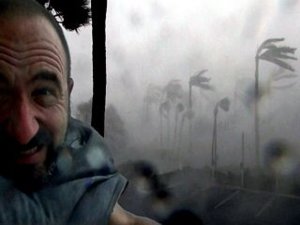
Above: Myself wedging myself between the side and a concrete pillar during the eyewall as the wind tries to rip my clothes right off my body.
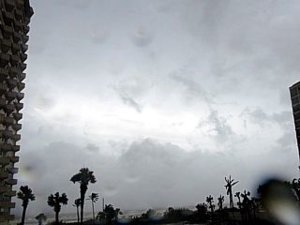
Above: View looking west inside the eye of Irma during nearly calm winds at about 3:30 PM. Winds became light and variable, and a minimum central pressure as low as 937 MB was measured inside the eye by Derek and I.
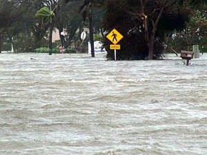
Above: Severe street flooding in the southern portions of Marco Island late in the day on September 10.
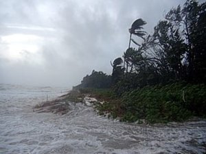
Above: View of Gulf of Mexico and storm surge pushing on shore in Naples, Florida at arund dusk on September 10. Winds here have decreased to 45 MPH or so, with tides 5 feet or so above normal (surge was less than the feared 10 to 15 feet predicted). This hurricane surf and surge here was pushing ashore and spilling into the residential streets, causing severe flooding. The view here is to the north-northwest.
This is my chase log for hurricane Irma in SW Florida. Details are below...
Summary: This area shows pictures taken from the interception and observation of powerful category-four hurricane Irma in southwestern Florida mainly during its landfall in Marco Island and into Naples (Collier County). Hurricane Irma was a deadly and powerful hurricane that made its way across the Atlantic from the Cape Verde Islands off Africa in the first days of September 2017. Reaching category 5 strength, with 185 MPH winds, the storm devastated the northern Virgin Islands, passing north of Puerto Rico, then into the southeastern Bahamas. On September 9, the storm scraped across the northern Cuban coast as a category 5 storm with 160 MPH winds, then turned north and passed east of Key West with 140 MPH winds early on September 10. Later that same day, the storm made its final landfall as a strong category 3 / minimal category 4 with 125 to 130 MPH sustained winds at Marco Island. Steadily weakening thereafter, Irma continued north through Naples and east of Fort Meyers, becoming a tropical storm early on September 11 in northern Florida and Georgia. Irma finally met its end to a destructive 13-day long route from west of Africa (around Aug 30) to the USA as it became a tropical depression and dissipated over the SE USA on September 12. Irma caused extensive damage (and even catastrophic) during its journey, with several landfalls (Barbuda and British Virgin Islands, Cuba, and Florida). This chase was a "local" chase in Florida, with chaser Derek Sibley joining me. We headed out of my area in Broward County and targeted the SW Florida coast for the September 10 landfall, which would be during mid-day and ideal. We stayed at storm chaser Mark Farmer's place in Naples, helping him with boarding up and such, and joined Brett Adair, Caleb Elliott, and many other chasers (who were also in TX in Harvey) at the American Sports Pub (only place open on Sept 9) for a pre-chase party. For the interception, we chose a parking garage at a beach-front resort early on September 10, on the southern tip of Marco Island (buildings there rated for category 5 winds). The eyewall and calm eye of Irma was experienced at this location. After the storm, we went back out and worked our way out of Marco Island, observing extreme flooding and some storm surge. After checking if Mark Farmer was OK (he stayed in Naples), we left Naples and headed back east to my place in Broward County. Power was out at my place for several days, and tree damage and some roofing tiles missing. The total mileage was 292 miles.

This is a picture taken from inside the inner eyewall of hurricane "Irma" as it was making landfall in Marco Island, Florida at roughly 3:15 PM EDT on September 11, 2017. The ferocious winds here are blowing with gusts exceeding 130 MPH, tearing apart palm trees, throwing debris across the area, and nearly tearing my shirt right off my body. This scene was lit by a brilliant flash of lightning and thunderclap barely audible over the roar of the wind. This was about 10 minutes before entering the calm eye of Irma (which had some sun peeking through).

These are two annotated images showing hurricane Irma as it made its final approach and landfall in the Florida Keys and into southwest Florida. The left image is a visible satellite image as the hurricane moving along the northern Cuban coast as a borderline category 5 hurricane late on September 9. The yellow arrow shows how the storm was to turn north, cross the lower Florida Keys, and move into the southwest Florida coast. To the right is a radar image (reflectivity) as the hurricane core was approaching Marco Island with winds at least 130 MPH. The eyewall is slightly eroded on the south side due to some dry air drawn into the "moat" region between the concentric eyewalls. The northern eyewall is where there is violent rain and also contains all the wind dynamics. The convective "chimney" of the storms right-front eyewall is the red region. To the north of the calm eye and hurricane core, numerous chasers (from Spotter Network) appear in Marco Island as red dots. The cross-hairs is my GPS location at the time.
Full video of Hurricane Irma is below...
Pictures are below...

Above: During the morning of September 10, from Naples and into Marco Island, the powerful offshore flow is pusing the waters of the Gulf of Mexico OUT to sea, resulting in a "negative surge". Marinas and docks are left high and dry and at the Gulf beaches you could actually walk great distances out on the sea floor!

Above: Myself wedging myself between the side and a concrete pillar during the eyewall as the wind tries to rip my clothes right off my body.

Above: View looking west inside the eye of Irma during nearly calm winds at about 3:30 PM. Winds became light and variable, and a minimum central pressure as low as 937 MB was measured inside the eye by Derek and I.

Above: Severe street flooding in the southern portions of Marco Island late in the day on September 10.

Above: View of Gulf of Mexico and storm surge pushing on shore in Naples, Florida at arund dusk on September 10. Winds here have decreased to 45 MPH or so, with tides 5 feet or so above normal (surge was less than the feared 10 to 15 feet predicted). This hurricane surf and surge here was pushing ashore and spilling into the residential streets, causing severe flooding. The view here is to the north-northwest.
