Hurricane Beryl

Joined
May 21, 2011
Messages
203
Location
North-central Nebraska
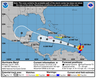
We've got the first 2024 Atlantic Hurricane this evening: Beryl moving west at around 20 mph. Notably, the African wave train's off and running seemingly early. Getting this thread started...Traditionally, storms that originate off the West Coast of Africa near the Cape Verde Islands that take the long, intensifying trek across the ocean tend to occur later in the season, September for example. In what's forecast as an active season, this late-June situation's raising my eyebrows.
 
Last edited:
Having lived in Texas and New Orleans, my thoughts turn to will it make it into the Gulf, and where will it go from there? NHC's not going out on a limb to specifically predict that at this time, and I won't either. Interestingly, as the wind speed fluctuates and goes down, the radius of strong winds gets bigger, affecting a larger area. (And this in contrast to the Pacific basin that's stunningly quiet.)
 
The NHC 11 p.m. report says that Hurricane Hunter recon indicates that Beryl's a Cat 5 with 140 knot / 160 mph winds. Here comes the shear after tomorrow and for the following few days to knock it back down. So, when it emerges into the Bay of Campeche, or heads toward south Texas, it should be a shadow of its former self in terms of wind. But, what an early wake-up call for coastal residents... if they're listening.
 
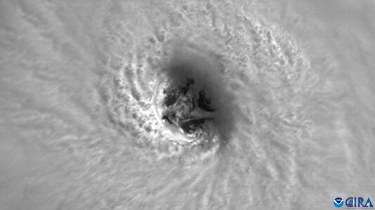
The visible-satellite imagery & time-lapse animation when Beryl appeared vertically stacked yesterday showed mesovortices within the eye wall.
Colorado State's got some great archives, of course: Hurricane Beryl
For example, swirling in the eye during Carriacou-Island landfall below. They've also got a fine Beryl-lightning "movie" to view.
Image.jpeg
 
Last edited:
Guidance has been shifting north over the past day or so, increasing the chance of a USA landfall. As for personal chaseworthiness, this one has a lot going against it for a US Gulf Coast intercept: possible sunrise landfall with the bulk of the action before dawn, risk of the eyewall staying south of the border, significant weakening to TS levels likely and the very long-distance drive to Brownsville.
 
TX is likely not done with this storm yet; Cat 1 (and tropical storms) can cause a lot of problems, too, as many know.
I remember the flash-flooding in the Lone-Star State when I experienced it in the Hill Country of south-central TX.
Even though airplane-recon of hurricanes didn't get started until the early1940s, and satellite observations of tropical systems took another couple decades to start (the early '60s,) one can still say that this storm "achieved" notable, high points for Atlantic hurricanes, listed below.
* Substantially east: First major hurricane east of the Lesser Antilles in June.
* Way south: Most southern hurricane w/ 150 mph winds (per AccuWeather.)
* And soon: Earliest Cat 5 that we know of in this modern meteorology-era.
 
Last edited:
Decided not to chase Beryl. Came down to logical decisions today (7-6) based on: It appears to be a nighttime-falling system with the main right quad coming in late Sunday into early Monday AM, it's currently ingesting a ton of mid-level dry air which is going to severely limit rapid intensification, the onshore quad is forecast to make landfall east of Corpus, in a crappy (sandbar) area for chasing and photogenic infrastructure. I'd rather spend the 1k+ chasing expenses on a more worthy storm, considering we are not even near peak season yet.
 
While Beryl heads NW at 10 mph towards Matagorda Bay, TX, I realized that it's the only tropical system in the world's ocean basins right now. Also, I found it interesting to think about the path of the storm vs. the coastline orientation. The more oblique the angle of approach (less than 90 degrees and becoming more parallel,) the greater a shift in the track affects the landfall location: Good info for future planning purposes.


Image 2.jpeg
 
Will need to keep an eye on how the dry slot evolves as the storm moves inland. This could be a decent inland tornado producer in its northeast quadrant in the coming days if some clearing can wrap into the remnants as some models have been suggesting.
 
Back
Top