2016-04-26 EVENT: TX/OK/KS

VBV is the biggest fly in the ointment as I see it. It seems moisture return will be adequate but the wind profiles are going to be somewhat limiting. As mentioned above storm relative helicity, while adequate for tornadoes is hardly indicative of widespread major outbreak at this point. The system is now fully onshore, model samples should start reflecting this with the 12Z runs I would suspect.
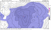
Another potential issue...the 00Z Euro has the low weakening throughout the day and retrograding back into NM. Going from 992mb at 0Z on the 26th, to 995 at 00Z on the 27th.
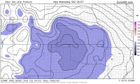
On the upside? It seems overnight some of the displacement between upper air and surface features has become somewhat more aligned...VBV is still bothersome in OK.
 
12Z NAM and GFS have both shifted the warm front / triple point up toward northeastern Nebraska. Don't like the near southerly 500mb flow up there. Dryline in OK has more southwesterly 500mb flow across it but not the greatest convergence along it and LLJ is shunted into eastern OK. Both areas have high SIGTOR values per NAM.
 
I don't care too much for the latest developments of this system. The low pressure appears to be occluding too soon, mid-level flow somewhat meridonal further north near the triple point, which could support a messier storm mode. In addition, the low level jet doesn't appear as focused, organized, or strong down the dry line, I'm thinking this is owing to a more disorganized cyclone. With that said, I think the threat further north near the triple point which latest 12z NAM has in E/SE Nebraska appears the most ominous from a tornadic standpoint.The best thing going for this system might be looking at things from a thermodynamic standpoint, quite robust CAPE and low level moisture values. With the variability of guidance, probably several more runs before we can nail down an exact target location.
 
I don't know if I am reading too much into this, but the last two runs of the GFS have shoved the trough and attendant surface low way farther north than previous runs. It also closes off the upper low. I mean, the triple point moved almost an entire state north. This much inconsistency this 2 and a half days out is making me nervous
 
I don't know if I am reading too much into this, but the last two runs of the GFS have shoved the trough and attendant surface low way farther north than previous runs. It also closes off the upper low. I mean, the triple point moved almost an entire state north. This much inconsistency this 2 and a half days out is making me nervous
Seems reasonable to me. Given all the other issues with the system, run-to-run consistency, surface vs upper air dynamics being displaced, VBV profiles, etc...
I like the 30% enhanced, seems reasonable to me. If they upgrade to MDT for day 2 I would suspect thats due to the hail threat which looks really impressive. While I think they'll be some tornadoes, the risk of EF3 or greater tornadoes, long-track, etc appear to be pretty limited right now. I think we could see a lot of quick spin-ups to EF1/EF2, stay on the ground 5, 7 or 10 minutes and then recycle, repeat....
At this point I'm not convinced we're due for some sort of epic outbreak.

edit: the Euro just caved to the more northern solution for the low. The 12Z vs the 00Z run has the low 300ish miles further north. What a mess. That will change the synoptic pattern...for those (myself included) who assumed the Euro was going to get the placement of the low correct...
 
Last edited:
Seems reasonable to me. Given all the other issues with the system, run-to-run consistency, surface vs upper air dynamics being displaced, VBV profiles, etc...
I like the 30% enhanced, seems reasonable to me. If they upgrade to MDT for day 2 I would suspect thats due to the hail threat which looks really impressive. While I think they'll be some tornadoes, the risk of EF3 or greater tornadoes, long-track, etc appear to be pretty limited right now. I think we could see a lot of quick spin-ups to EF1/EF2, stay on the ground 5, 7 or 10 minutes and then recycle, repeat....
At this point I'm not convinced we're due for some sort of epic outbreak.

Which would be fine to me. I don't need a violent outbreak, but I am not about to commit a 10 hour drive out there for a messy mode condusive to squall lines. They way it has all been trending is making this a very difficult choice, and if we do go, picking a target still seems way up in the air. With these shear vectors the warm front play looks to be less than stellar as storms will likely cross the boundary even if they are right movers. Meanwhile, the dryline shear vectors could lead to messy storm interference as they don't move too far off the line.
 
It seems to me that the dryline is looking a little more diffuse on this morning's NAM run, and the models aren't breaking out much precipitation until after 0Z. I am concerned that this could mean a largely after-dark event. The NAM does really ramp up the significant tornado parameter between 0Z and 3Z. Whether this translates into sunset tornadoes or an after-dark event is unclear, at least to me. Also, the NAM seems to be forecasting the development of some kind of secondary low around the OK panhandle in the evening, with the heaviest precipitation actually forecast in that area rather than farther east. Just east of that feature, the low-level directional shear is pretty decent, but the location of this feature seems to be behind the dryline. Not too sure what to make of this. Overall it seems like a rather messy situation, though one with some decent potential, no doubt. I like Chris face a 10+ hour drive, so still undecided about chasing this one.
 
I don't know if I am reading too much into this, but the last two runs of the GFS have shoved the trough and attendant surface low way farther north than previous runs. It also closes off the upper low. I mean, the triple point moved almost an entire state north. This much inconsistency this 2 and a half days out is making me nervous

I have been noticing this as well. It is likely due to increased impact on our Tuesday low system by the next one upstream. I went into SPC's Violent Tornado webpage http://www.spc.noaa.gov/exper/outbreaks/outbreaks-regions.php# and looked all outbreaks of >= 4 violent tornadoes within a 3-day period. I only found one event (May 2, 1942) that could be an analog for what we will be facing (e.g., back-to-back upper lows of similar paths/intensity that directly impact the OK/TX/KS region in the course of a few days). In the analog event, no tornadoes occurred with the leading system on April 30th while 8 tornadoes, including one violent one, were recorded on May 2nd. From available data, it appears availability of low level moisture was the difference in the impact from the two lows.

So...based on latest model runs and analog cases...I would not expect a tornado outbreak, especially with violent tornadoes...for Tuesday. However, we should keep a wary eye on the next low coming in for something more significant (but that is for another thread).
Not a huge fan of basing things off analogs especially older analogs when additional parameters aren't necessarily available or accurate.

Your point overall about the system being overhyped is valid at this point. Everything points to a high end hail day with perhaps numerous smaller or quick spin up type tornadoes. I'm not seeing much that would indicate support for strong, long track tornadoes. SRH 0-1km of 200 m2/s2 is adequate for tornadoes but pretty poor for a moderate to high end outbreak type event. There is just way too many small issues, add them up all and it's pretty inhibitive of a significant outbreak. That could change pretty quickly though, so it certainly warrants keeping a close eye on. I'm likely chasing since it'll be an enhanced risk or an MDT at day 1 for N Central OK.
 
Seems reasonable to me. Given all the other issues with the system, run-to-run consistency, surface vs upper air dynamics being displaced, VBV profiles, etc...
I like the 30% enhanced, seems reasonable to me. If they upgrade to MDT for day 2 I would suspect thats due to the hail threat which looks really impressive. While I think they'll be some tornadoes, the risk of EF3 or greater tornadoes, long-track, etc appear to be pretty limited right now. I think we could see a lot of quick spin-ups to EF1/EF2, stay on the ground 5, 7 or 10 minutes and then recycle, repeat....
At this point I'm not convinced we're due for some sort of epic outbreak.

edit: the Euro just caved to the more northern solution for the low. The 12Z vs the 00Z run has the low 300ish miles further north. What a mess. That will change the synoptic pattern...for those (myself included) who assumed the Euro was going to get the placement of the low correct...

Just a question here, did you mean the Warm Front being further north? Looks like the surface low is a tad deeper (996mb area larger) and a hair further west. But overall the cyclone being a bit more broad to the NE.

The Euro has some precip starting on the dryline in OK around 18z, and then really firing off by 00z.

But to agree with others here I think you might have one cell go bonkers on the dryline, and not quite sure to make of the TP yet with the lack of consistency.
 

Attachments

  • 0Obdj8V.png
    0Obdj8V.png
    1.1 MB · Views: 210
  • untitled.png
    untitled.png
    1 MB · Views: 206
Just a question here, did you mean the Warm Front being further north? Looks like the surface low is a tad deeper (996mb area larger) and a hair further west. But overall the cyclone being a bit more broad to the NE.

The Euro has some precip starting on the dryline in OK around 18z, and then really firing off by 00z.

But to agree with others here I think you might have one cell go bonkers on the dryline, and not quite sure to make of the TP yet with the lack of consistency.
Warm front appeared further north, the low itself was positioned quite a bit further north as well. But I don't have access to hour by hour euro info. It's in 24 hr increments so I'm comparing runs but it's not apples to apples because of the 12hr spacing between the runs.
 
In the EC and NAM, there are two upper low centers--one in SE CO and the other in SE WY. The GFS does not have this structure. The GFS will be wrong, as it has been with virtually every major storm this winter... Overall the pattern today looks more favorable for outbreak than it did yesterday (trough is looking a lot more negatively tilted!) despite the NAM failing to initiate things earlier, as it was doing yesterday. I'll look more closely at the 00Z runs.
ETA: not seeing any VBV in central OK soundings...
 
As I am unable to leave town until 11am on Tuesday at the earliest, I was considering a chase of the southern target south of the Red River. But at this point, I'm not very keen on even making the drive out to the area near Wichita Falls due to the VBV being pretty ugly. There will be plenty of energy but I have a feeling we're going to see a QLCS develop rather quickly. At this point the setup down here reminds me a lot of April 24th last year. We got a few discrete cells early in Texas on that day, but things quickly congealed into a line after that. The wind profiles have been consistently getting worse down here for two days so at this point I am more inclined to sit it out rather than chase the southern area.
 
I posted this discussion to Facebook earlier, but I figured it might be good to share it here too.

I was a bit confused as to why the NAM4km wasn't convecting at all given the high thermodynamic parameter space and extremely low LCL/LFC heights along the dryline. This is not an assessment of the validity of the forecast itself (I actually think something is fishy with the NAM4km solution at 850), but more of an investigation into why we're not seeing widespread convection being forecast by the model. If you would like to see the comments and discussion going on there too, which is also quite rich, the link is here: https://www.facebook.com/stormchaserkelton/posts/983784018385352


Initially, looking at the depth of the dryline circulation by taking soundings from either side of the dryline, the depth of the mixing is more than sufficient to bring a parcel to it's LFC. This can be approximated by looking at the top of the boundary layer (dewpoint trace of const. mixing ratio) on the dry side. Clearly, it's well above the LFC on the moist side. Typically this favors convective initiation, but this is not the case.
7a3cb02cdbdfb91ea265a335a0b624ca.jpg
3bb46b5d3bc306569947ceeb5a0f75f8.jpg

Looking at the 850mb and 700mb forecast maps, I believe the reason to be due to a boundary orthogonal component of the wind to the dryline at both levels. My understanding is that this can serve to do two things: 1) it can have influences on dry air entrainment into budding updrafts, which is typically not good, and 2) it greatly reduces the residence time of the updraft on the dryline, meaning that an updraft may not be in the area for ascent long enough to reach it's LFC.
72e20cedddba3dd1ecbe0c874a2fb8d7.jpg
f31b32f761f6bee04a8a6e5497e85cac.jpg

Unfortunately, all the parameters in the world mean nothing if you can't get a parcel to it's LFC. Thankfully (whatever that means?) the NAM is much more southerly with the 850mb wind. If you want an active severe day, that's what you're going to need to look for.
 
If I recall correctly I believe Rich Thompson, correct me if I am wrong, in his tornado forecasting workshop touched on a similar forecast complication which occurred in the days leading up to the April 14, 2012 event. He noted, as a reason not to rely totally on the models, the models did not forecast any warm sector convection for that forecast period. He gave an explanation however I do not recall the details at this time. Perhaps someone else remembers the specifics better that I. The science says moisture, conditional instability and a source of lift. All three will be present over a large part of the warm sector on Tuesday. My concern is the timing of the lift which could potentially make this a nocturnal event.


Sent from my iPhone using Stormtrack mobile app
 
Back
Top