2016-04-26 EVENT: TX/OK/KS

Joined
Mar 30, 2008
Messages
1,438
Location
Norman, OK
Fitting that the 25th anniversary of the Andover, KS F5 tornado event would show what will likely be a classic plains tornado outbreak.

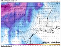
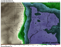
The GFS (12Z 20160420 f156) shows a very strong low (993mb) over SE Colorado with a dryline trailing thru SW KS/W OK/NW TX. That dryline should be a focal point for strong supercells in a warm sector with dewpoints in the upper 60s to low 70's F. MLCAPE values of over 3500 are already showing up in some of the soundings with very favorable hodographs for tornadoes.

Here's the current run dewpoint map for archival purposes, should this become the huge event it looks like.
02010c5c3c9712cbc49082644d98406d.png

Same for 500mb winds valid 00Z

ededa124dbc1f1c5e83bd4b0444359e5.png

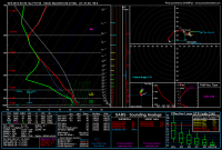
Here's a sounding from near Medicine Lodge, KS at 00Z from the GFS. Classic "loaded gun" soundings showing up all along the dryline with a very breakable cap. Lapse rates look amazing once cap breaks.
43edc3ff887d17a6d97da2e0a7c2984f.png

Tuesday looks to be a very dangerous day in the southern and central plains.
 
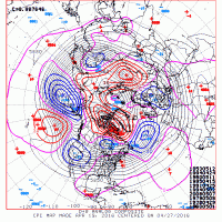
Next week certainly has potential and several analogs identify big days/busy periods in the past, including Andover. I don't feel confident enough to make specific calls this far out, but I'll leave y'all with some of those analogs from a recent GEFS run.
610analog_160419.gif
 
This will undoubtedly be the headline event for the week. Certainly it's too far out for details and such, but this is beginning to look pretty impressive/scary.

I won't touch too much on things for now since it's so far out but something I found interesting was the analogues for certain soundings. May 3 99 came up. We'll see how things unfold but the run to run consistency has been there.
 
Synoptic pattern-wise, I don't think it gets much more classic. A digging, neutral to slightly negative shortwave with the main jet maxima ejecting onto the High Plains around 00Z with lee cyclogenesis rapidly deepening the SE Colorado sfc cyclone. One run shenanigans aside, it's hard to not get excited with that kind of signal even a week out. It falling on April 26th of all days would just be too perfect.
 
It would not surprise me at all to see the very sharp Warmfront, (which the 12z GFS progs to be just north of the KS/ok boarder by 0z) drift south over future runs or when the NAM comes in. It seams the GFS always overdoes the retreat of a reinforced frontal zone. (there is a strong surface high pressure center to the north)

(haven't looked at the 18z yet!)
 
One thing that stands out on the GFS...deep low-level moisture is in place more than 24 hours days before
the day in question. That is almost a requirement for the bigger tornado outbreak days in the Srn Plains.
You don't have to rely on return flow from the GoM that is modified cP air...eech! Sunday a low pressure moves
W-E across the Nrn Plains with the front just stalling out in cntrl OK, not sweeping SE into the GoM, so
pre-event set up is looking quite good right now.

I attached the 21z panels for 4/26/91 and 5/3/99. There are some similarities in the 500, of course it is all
in the details and a long way to go!
apr91.jpg may99.jpg
 
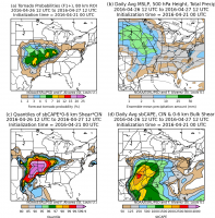
And here is the GEFS Reforecast tornado probabilities for Tuesday. These are somewhat high odds for being this far out. I think the eastern extent of the probabilities might be a little high though. Of course, assuming the timing does't change too much the threat could easily move east on Wednesday.

98357fc6c87fbfa74dd46ae0e1c27f1b.png
 
Considering flying out for this one. I won't soon forget April 26, 1991. My biggest concern will be the DL throughout the day and how far east it pushes. Right now the 12z GFS has it borderline near the jungles east of I-35. But remembering 1991, tornadoes were produced rapidly by almost every storm that formed anywhere near the DL. Could be another scary day for central OK.
 
The 12Z GFS today and really the 00Z GFS last night still paint a scary picture for the I-35 corridor from Wichita south to almost DFW. SPC obviously has touched upon this in the latest Day 6 outlook, highlighting a 30%.

Great moisture with dewpoints in the upper 60s to low 70s across the entire area, as Boris said above, well in advance. Sunday's shortwave doesn't send moisture south, and leaves the southern plains moist and pretty unstable.

I think the only REAL concern right now with things as they have stood for a few model runs now is the fact that 850mb winds seem to have a little westerly component to them. With moisture at 850 and the amount of CAPE, I'm not sure that will matter much, but I'm trying to find something wrong with it.

The EURO, from what little I have seen of it, is pretty much showing the exact same thing as the GFS. The amount of consistency between models has been very good.
 
Considering flying out for this one. I won't soon forget April 26, 1991. My biggest concern will be the DL throughout the day and how far east it pushes. Right now the 12z GFS has it borderline near the jungles east of I-35. But remembering 1991, tornadoes were produced rapidly by almost every storm that formed anywhere near the DL. Could be another scary day for central OK.

I will take Warren's advice. I will find a simple cumulus cloud. Wait 10 minutes and watch as it becomes a tornadic supercell.

From looks at the 18z GFS it looks like the show will be potentially I40 and north. North Central Oklahoma soundings are insane. Moisture depth is good. Upper 60 and possible 70 Tds. By 21z 850 hPa winds will already be around 35-40 kts. And they strengthen up to 50+ by 03z.

So as Warren said. Storms will rapidly acquire rotation.

Chase target will be back yard for me. I will try to point all cameras I have toward the West in case one gets me.
 
There is a decent cap, not worrying me too much at this point, actually I like it as it reduces chance of any early stuff screwing things up. But it does make me favor the NC OK/SC KS area. little cooler mid level temps, surface convergence better, 850 wind direction and surface SEerlys are really best in this area AT THIS POINT. much will still change.
 
Last edited by a moderator:
Despite the great near-70 dewpoints in central OK, the gradient does not look particularly sharp, looks like there is a sizable area of 50s between the dryline and the deepest moisture. I might prefer to be near the warmfront/dryline intersection up against the surface low in SC/SW KS, where the deep moisture wraps in and both surface and 850 winds are more backed. Negative there is that 500mb winds are slightly more meridional so not intersecting the dryline at the best angle and could steer storms across the warmfront where temps appear to be relatively cool.

Wish I could be anywhere out there, but my chase vacation is not for another month.
 
Really liking the set up for Tuesday, and for now am considering a play in/near SC Kansas near the surface low and DL. Backed winds at the surface, ample, deep layer moisture, and that 60 kt mid level jet should make things go boom during the late afternoon, and especially near 0Z. That 40-50 Kt LLJ that kicks in later on should make things interesting after dark and into the overnight. I'm glad I've been taking vitamins because this is going to be a long week.
 
Still a few model issues with this but it looks promising. Not getting my hopes too high till its fully sampled Sunday morning.
This does look impressive, given the ground saturation, it seems to me the GFS is mixing a bit too far east, I wouldn't be surprised to see this back west some 50-75 miles maybe? Wind profiles look decent, a touch of VBV but it's early yet. Really looking somewhat ominous for the OKC metro, Tulsa as well at this point...but if it drifts back west that'll help keep Tulsa on the fringes. Seems discrete cells will be possible well into the evening and overnight hours as well.
I'm still recovering from Tornado damage a few weeks ago, so I'm hoping I don't get hailed on :(
 
Back
Top