2015-04-08 EVENT: KS/OK/TX/MO/AR

Think Ill add my thoughts to the board. Overall my target Wednesday afternoon is along the Northern dryline near Lamont Ok. Leaving Norman Around 2 and getting there by initiation will be no problem.

Positives:
Strong cape
Good shear
Good moisture
Decent convergence and forcing from the dryline and some weak lift from the trough.
Backed Surface winds

Cons:
Uncertainties with cap strength
Trough timing issues
Moisture depth


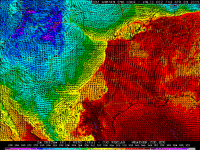
First lets take a look at Obs. Gulf moisture is there. Buoy and Texas coast sensors indicating low 70's to upper 60's pooled along the coast with southerly winds blowing that north for the next two days. We can expect a decent lowlevel jet the next two night as well with a few smaller waves translating over the region. Obviously that moisture will be there come wednesday. One concern is the depth of that moisture.
Screen Shot 2015-04-06 at 2.35.51 PM.png
While I dont think it is a major concern it is something to pay attention to. /u/Kelton Halbert pointed out the moist layer is a little on the lower side at about 1km thick. That being said observations still show moisture will be in place and likely be of sufficient depth for severe storms. One thing to note is that trajectories are showing the moisture "taking the long way around." This entails the deeper moisture residing over coastal Mexico and SW Texas. It is originating from the lower gulf near the YucatanScreen Shot 2015-04-06 at 2.59.55 PM.png and advecting first NW then to the Northeast. Indeed looking at SPC Mesoanlysis and KDRT Observed soundings, the moisture is deep with 850 MB mixing ratios near 12g/kg and 925mb near 16 g/kg.
Screen Shot 2015-04-06 at 2.45.12 PM.png

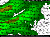
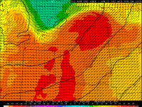
Looking to the west obs right now are showing a dryline through west central Ok with dry air sitting in the Tx Panhandle. The very dry air aloft will be advected over top of the moist air thanks to the SW 700 mb winds. THe EML will be of moderate strength with 700 mb temps this morning in Norman near 15C. Amarillio shows a deep mixed layer with 700 temps near 20C. This is a little bit concerning given how warm that is, but over the next few days this should cool slightly with the impingement of the upper level cold front front on Tuesday night. The lapse rates that will be being advected are nice and steep which if storms get established will mean explosive growth.

Screen Shot 2015-04-06 at 3.03.59 PM.png


Wave timing appeared to be another issues but looking at WV imagery it shows the trough over California ready and waiting to move over the area. Which will provide plentiful shear and some decent lift.

Screen Shot 2015-04-06 at 2.36.42 PM.png
The lift from the trough convergence from the backed Surface winds, and the relatively deep dryline circulation should also work to erode the CINH with probable (70%) initiation somewhere near 21-22Z. Overall Im impressed with the environment. Strong shear and instability working in tandem with good surface features gives me a good feeling about a few isolated storms with tornado potential possibly even a strong one. The initiation sounding from Ponca City is shown below.

Screen Shot 2015-04-06 at 2.34.09 PM.png

As you can see a good environment with several analogues for severe weather. Im very optimistic for a good chase day with a few storms and possibly a few tornadoes. Dont let the idiot masses on Facebook trick you, this is a pretty good looking environment.
 
The 3rd best analog for this mornings 12z run is 5-9-03 (none of the other dates caught my eye) : http://www.eas.slu.edu/CIPS/ANALOG/event.php?reg=SP&fhr=F060&model=NAM212&dt=2003051006

At least the analogs are still matching up to some previous tornado days so far :
SVRtornnam212F060.png


It is not that the setup looks bad (yet), but it is the trend that will make you worry. Definitely still looks like some tornadoes to be had on Wednesday, if it holds. I am just not a thrilled with what the 500s are doing leading up 0z and just afterwards. OK definitely looks better than KS in that regard. The main energy should be coming on shore tonight so hopefully with some better sampling of the system, issues that we are seeing can be lined out a bit better. I am curious mostly to see what the 12z run brings tomorrow as the system will be mostly on shore by then. My bias to a more western setup has not liked the eastern slide the GFS has done to the dryline, but the Euro has stayed with the NAM keeping it west of I-35 so far. If it ends up east of 35 for initiation, I would likely just stay home. I still think the dryline will spit out a couple options south of the triple point, but how far south is what I am not sure about.
 
00z NAM is in. One thing I've noticed is the surface have veered little by little on the last few runs. Now you are lucky to find south winds ahead of the dryline, they are mostly ssw. Helicities aren't great even by 21z unless you are right on the triple point. Helicities get better by 00z but surface winds still don't look great to me.
 
Yes, the NAM has backed off backing of the surface winds. However, the NAM nest has a couple interesting DL bulges west of I-35. While convection does not break out there, it's very interesting to see that present in model guidance.
 

Attachments

  • nam4kmSGP_sfc_thetae_048.gif
    nam4kmSGP_sfc_thetae_048.gif
    115 KB · Views: 255
The 00Z NAM is getting ugly for Wednesday in my opinion. The 850 winds trace all the way back to big bend and generally look ugly. 250/300mb has a huge gaping hole in Kansas. This looks to be going down hill in a hurry.
 
There still remains one "obvious" target near the front somewhere just northwest of I35 from near Newton towards Salina and ENE from there. I continue to dislike the veered 850 mb flow that models are forecasting. The attached image is from the 00z NAM this evening showing 850 mb wind and temperature at 18z on Wednesday. Note the WSW flow in parts of western OK and northern Texas, then the SW flow in KS that moves the slug of warm 850 mb air over that part of the warm sector. Eek! The 850 mb winds do back a bit to SSW or SW by 00z, but the damage may be done by that point (e.g., very strong capping). Alas, this is part of the reason, I suspect, why the 00z NAM essentially cap busts the dryline potential Wednesday. The 4 km NAM from this evening initiates two rounds of convection in southern and eastern KS, though it also has a small track of QPF 21z-00z from near Weatherford to Guthrie. Otherwise, the dryline stays capped on the 4 km NAM as well. Maybe there will be one storm in OK after all, but it's looking dicey. The better bet remains near the front in KS, but chase terrain up there is not the best (Flint Hills? Ugh), and, with such a focused target, congestion from spotters/chasers/media/etc. may get ridiculous.

250 mb flow is forecast to weaken substantially over KS during the late afternoon. However, some of that weakening may be associated with the development of convection and the adjustments the model makes to account for the forecast convection in extremely high CAPE. Of course, we cannot extract the "background" flow in the absence of the convection since the model has the convection in it, but it may not be quite as weak as it appears. It doesn't look particularly good, however, that's for sure.
 

Attachments

  • namFLT_850_temp_042.gif
    namFLT_850_temp_042.gif
    55.1 KB · Views: 300
The 00Z NAM is getting ugly for Wednesday in my opinion. The 850 winds trace all the way back to big bend and generally look ugly. 250/300mb has a huge gaping hole in Kansas. This looks to be going down hill in a hurry.

Ben,

I would probably investigate what that big hole at 250mb is before taking any stock in it, because it looks highly suspicious to me :).

With a quick investigation, it turns out it's convective feedback from the NAM. Just take a look at 250mb vertical velocities. In essence, I would not call that signal real. Always interrogate the data!

NAM_221_2015040700_F48_VVELD_250_MB.pngNAM_221_2015040700_F48_WSPD_250_MB.png
 
Ben,

I would probably investigate what that big hole at 250mb is before taking any stock in it, because it looks highly suspicious to me :).

With a quick investigation, it turns out it's convective feedback from the NAM. Just take a look at 250mb vertical velocities. In essence, I would not call that signal real. Always interrogate the data!

I think some of it may be from the model doing its thing with deep moist convection in 3000-5000 j/kg CAPE. However, this weakness at 250 mb shows up moving northeastward from central NM into southwestern KS even at 18z, well before any convection develops. As such, I think there *is* a weakening of the "background" 250 mb flow for whatever reason (it looks highly ageostrophic in nature since the height gradient at 250 mb does look like it changes much during the day) , even if it may not be quite as bad as the NAM forecasts after it blows up a convective bomb later in the afternoon.
 

Attachments

  • namSGP_250_spd_042.gif
    namSGP_250_spd_042.gif
    46.9 KB · Views: 295
To me, the death knell for the outbreak scenario many had latched onto a couple days ago was the gradual trend toward a more positive-tilt, lower-amplitude upper trough over the past 48 h of runs. Note that on Saturday morning's runs, there was a consensus that the trough would kick out into the Plains on Thursday afternoon as a closed low with several (60 m at H5) contours, and a neutral to negative tilt. Now? That energy is shearing out and progressing into Iowa by late Thursday as it begins to phase with the northern stream in Canada.

It's amazing to look back over the past couple years with regard to this issue: I don't think we've seen a KS/OK/TX severe weather setup with a negative-tilt trough, favorably-oriented (N-S or, god forbid, even NNW-SSE) dryline, and ample low-level moisture since May 18, 2013. Despite the generally impressive kinematics aloft and seasonably decent moisture, the lackluster PVA on current model solutions leads to mediocre and late backing of low-level flow, hampering dryline convergence and simultaneously increasing CINH (as described by Jeff above). I'm quite concerned about getting any impressive storms at all Wednesday if this doesn't change, because the lone "triple point storm" that's consistently been advertised by the NAM and its 4 km nest rides right along the stationary/warm front with low 50s F surface temperatures immediately to its N. I think we're going to need something to fire at least a little S of the true triple point to have a good chase day, even ignoring chaser convergence issues. And I trust the higher-resolution mesoscale models over the globals in depicting the frontal position and degree of cold air to its N -- particularly this early in the spring.

Of course, it's still possible that model solutions will trend the other way tomorrow once the bulk of the upper energy finally comes ashore. At least tonight's NAM didn't continue the trend toward lower amplitude and a positive tilt [I don't agree with those acting like tonight's run is this big dropoff; the NAM, at least, already looked similarly nasty by last night, and especially this morning]. I tend to agree with Gabe's post this afternoon in that this system likely will find a way to produce at least a couple tornadoes Wednesday, but we're on shaky ground right now with regard to anything impressive chase-wise.
 
The 00Z NAM is getting ugly for Wednesday in my opinion. The 850 winds trace all the way back to big bend and generally look ugly. 250/300mb has a huge gaping hole in Kansas. This looks to be going down hill in a hurry.

I mean, this is what I'm seeing from the 00Z NAM, and it looks pretty damn good:

00_NAM_048_37.68,-96.49_hodo.gif


Great helicities in the low levels, right at the time and location that a cell would be chugging along north of Wichita.
 
I think some of it may be from the model doing its thing with deep moist convection in 3000-5000 j/kg CAPE. However, this weakness at 250 mb shows up moving northeastward from central NM into southwestern KS even at 18z, well before any convection develops. As such, I think there *is* a weakening of the "background" 250 mb flow for whatever reason (it looks highly ageostrophic in nature since the height gradient at 250 mb does look like it changes much during the day) , even if it may not be quite as bad as the NAM forecasts after it blows up a convective bomb later in the afternoon.

Yes, I did see the weaker 250mb flow in the previous time steps as well, and would not disagree with your assertion regarding the weakness of the background flow between the two jets. My intention behind the post was more to point out that it may not be wise to jump to conclusions regarding something seen in the model data without interrogating it first. I'n a situation like this, it's very easy to start writing something off when the process causing the feature may or may not be physical. I'm almost completely certain that the majority of that weakness between the two time steps is due to the convective parameterization - I've seen it happen multiple times in both the NAM and GFS, and the telltale sign is always the bullseye in vertical velocity/omega.

This does not serve to address the other issues with the forecast. I'll have more to say on that in a little bit once I finish looking at stuff...
 
One thing to Note is the difference in the shape of the trough from the 12z Euro and the 00Z nam. The NAM is slightly more progressive with the trough and has more of a positive tilt associated with it. The "pinched" trough is whats weakening the surface low and veering the 850's and the surface winds. The ECMWF is more broad and slightly slower with the trough keeping the wave "less closed" and slightly behind which keeps mostly southerly 850's. The 00z NAM also differs with the 12z run by amplifying the upstream ridge and deamplifying the shortwave impulses ahead of the main wave. Im not exactly sure what the NAM is reacting too. Low level flow has no reason to be oriented to the south west given mass response from the 998 projected Low. I think the 00z Nam is off with the winds. NAM soundings are also showing the cap being weakend by 19Z then reforming and opening up again shortly after. The trough it's self is still not being fully sampled by the obs network so Ive yet to write this off as we still have over 45 hours to go.
 
I mean, this is what I'm seeing from the 00Z NAM, and it looks pretty damn good:

00_NAM_048_37.68,-96.49_hodo.gif


Great helicities in the low levels, right at the time and location that a cell would be chugging along north of Wichita.

I may not be properly speaking for Ben, but I think he may be talking about the storm relative flow in the upper troposphere. Look at the black star indicating the predicted right-mover motion. There's very little storm-relative flow between 300 and 200 mb, likely near anvil level. That kind of hodograph basically screams HP. Doesn't mean there won't be a supercell or even a tornadic supercell, but it will be HP/messy.
 
[QUOTE="Brett Roberts, And I trust the higher-resolution mesoscale models over the globals in depicting the frontal position and degree of cold air to its N -- particularly this early in the spring."[/QUOTE]

Brett you need to be very careful taking full stock on a mesoscale model such as the 4km nam 48 hours in advance. Boundary layer paramaterization can wreak havok on surface features in the high resolution models. The NAM 4km has issues that have been consistently showing up such as underdoing the EML and firing convection before 20Z. Its very aggressive with the cold air advection north of the front along with the 12km nam. It needs to like all model data be taken with a grain of salt.
 
Back
Top