2015-04-08 EVENT: KS/OK/TX/MO/AR

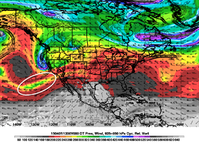
I came across this analog for tomorrow, that I think matches up quite well. It actually helps rest some fears I have about tomorrow as it shows basically what the NAM has forecasted for Wednesday but still spit out some good tornadoes. The dew were higher for this day, but I still feel they are comparable in most aspects.

Be sure to check out some of the sounding from that day and the radar loop.

I give you May 7, 2002 - http://www.eas.slu.edu/CIPS/ANALOG/...=NAM212&fhr=F036&dt=2002050806&HH=-99&map=SVR

For old data from that day, use this - http://www2.mmm.ucar.edu/imagearchive/
 
Let me add a few notes to what I posted last night with respect to the upper level flow.

I tend to be a little more suspicious than others with regards to how much the satellite observations can contribute to certain setups. Their benefit is still how many of them get assimilated into the numerical weather prediction model, but there is processing that still occurs that thins/bias corrects the data and I am yet to see any real-time metrics that provide good information on data impacts. On average, satellite data is a real workhorse when you look at the contributions of them to model error reduction, but if you were to look at the impact from a single observation, radiosondes will win out over satellites. There are multiple things that come down to model errors: initialization, parameterizations schemes, model dynamical cores. Given the differences in timing we've all observed, we have to question why we have these errors? My educated guess is that this is an initialization problem, as I cannot see synoptic scale timing issues being significantly associated with parameterization schemes and model dynamical cores this far out. I may be wrong in this respect, but it's an idea I began developing last night when I was looking at the water vapor imagery. The water vapor imagery and this morning's 500 mb charts reveal quite a bit about where the uncertainty of the synoptic scale ascent may come from ( at least from a vorticity advection perspective ). Last night, I noticed in the WV imagery that our primary trough circulation had multiple shortwave troughs that were quite small and a little hard to pick out. The assimilation schemes may not be able to identify these, even given all of its observations (again just an idea), which is why I wanted radiosondes as a second opinion. Given how slow this trough is moving, I'm guessing that the synoptic scale ascent may come in the form of a lead wave, such as many of the ones I've analyzed on this morning's 500 mb chart (see below) that this trough has been ejecting out ahead of it. The uncertainty of a lead wave might be our issue.

24o7yix.gif
 
The 12Z NAM still isn't a slam dunk, but as Jeff Snyder points out, the S-shaped hodographs are gone, at least along the dryline, for the most part. I'm still worried about the 850 flow as it'll be blowing dry air from new mexico/texas into the dry line but the NAM still shows decent moisture at 850 regardless.

We're sitting at a dewpoint of 66 here in Norman with 68 showing up on the mesonet just south of us at Byars. Moisture depth still seems to be a problem per 12Z soundings but I've chased many less ideal setups and it still seems like we will have plenty of moisture to work with.

Still seems like we have some weakness at anvil level and may run into messy storm modes. I'm also not sure if that would make the area between the 2 jets subsidence or not, but that would be a concern of mine if it did.
 
If we look at some of our old dynamic meteorology books the double-jet-streak phenomenon may shed some light on our issues. DPVA ahead of the trough within each streak will create divergence and better outflow directly along the streaks. Along the outside edges of the streak, winds are lighter. When you put two streaks next to each other, it then follows that the area between the streaks will have weak winds aloft and no bonus from DPVA, an important source of upper level vorticity and outflow. I'll let you draw your own judgements from there, but HP is a likely storm mode.
 
We've come in range of the Storm Scale Ensemble of Opportunity.

It picks up on what others have mentioned about the early afternoon convection in north central OK/KS, and then lights up the entire dryline shortly thereafter. I don't have time to post a full analysis because I have to run some errands, so full thoughts later. Food for thought though.
sseo1.png sseo2.png
 
Kind of late to the party, but it looks like the moisture just above the PBL will be originating from the Del Rio/ N Mexico area. The 12Z sounding this morning showed a ~1km deep moist layer present, with the drier air displaced further southeast away from the main fetch above the surface.

[Broken External Image]:http://www.spc.noaa.gov/exper/soundings/15040712_OBS/DRT.gif


It's looking likely that storms will initiate within the next hour or two on the dryline in N OK/S KS, which will definitely be something to watch for (whether that be convective debris or an OFB).
 
Been a while since I've been here. Thanks and kudos to everyone who worked on revamping the site!

SREF's done it for days, NAM's doing it, now SSEO is sorta doing it, and SPC treated it as credible in the Day 2 update. I guess I'm still having a tough time believing that a lead shortwave is going to annihilate this particular cap at noon. We'll see what 12z raobs look like, but 15-17z CI just seems unthinkable tomorrow.

On the other hand, am I seeing something that's not there, or has NAM slowed down that little impulse over the last few runs? Here's 700 mb at 18z Wednesday, from the 00z run:

Screen Shot 2015-04-07 at 4.45.01 PM.png

And the same thing from the 18z run:

Screen Shot 2015-04-07 at 4.45.11 PM.png

If that's what's happening, slowing the shortwave and getting some heating ahead of it might make initiation accompanying it more believable. It would make the 18z 4km NAM look reasonable in minimizing inhibition around 20z and only then producing substantial convection.
 
0z 4km NAM breaks out some nice precip along the KS/OK border late afternoon/early evening. By far the best that has looked any on of the previous runs. Looking at surface winds the dryline and triple point look a little more diffuse than previous runs and CAPE looks to be down a bit but still plenty to get things going. All things considered Wichita still looks like a safe starting point.
 
Well, I suppose I'll be the first to post it...


Current SPC Day 1 Outlook has a very large 10% hatched tornado risk. Despite the negatives addressed in the forecasts, it appears as if this thing could be getting it' act together. Definitely looking forward to seeing what the 12Z observations tell us!

day1probotlk_1200_torn.gif

Right now, I'm thinking of setting up inside this box (probably Blackwell) and going from there. I don't get out of my exam until 2:45, so I'll be a little late to the game, but overall I'm pretty excited about tomorrow.
11039197_788332124597210_7432545653408898757_n.jpg
 
From my quick 7 minute model peek, I’m not super excited about today. 500mb winds parallel to the surface feature in KS… Fairly straight hodos. But the CAP should help keep things semi discrete enough to give them a chance. Oklahoma is probably going to have the best shear, especially as the RAP predicts cyclogenesis and backing winds in the evening, but that’s out of range for me, and the lid may be stout. Being in Kansas City, I’m going to keep an eye on this warm front lifting into northern MO…if we could get a little perturbation to cause some strong lift in this area along with some clearing during the afternoon…I think cells could pop up there…less chaser convergence would be an added benefit.

Alternatively, NAM and RAP were showing lower Lid Strength indices for areas east of Wichita around late afternoon. That will be my second option. The frontal placement and CAP remind me a little bit of last night. And since storms fired a little after sunset last night, I’m sure they will fire an hour or two before sunset tonight, since we have significantly more upper level support. I think we may go Moderate risk for hail. I can’t see tornado percentage increasing above 10%
 
My initial target will be E KS, just east of I-35, maybe straight south of Emporia on 99. With the cells that popped up in SE KS last night and storms in W MO this morning, there should be some decent outflow boundaries for storms to interact with once they get past the I-35 corridor.
 
I paid too much attention to Thursday and will be at work today so I don't want this to be confused for location-bias, but I'm really starting to wonder if there won't be something big in SW Illinois, or perhaps eastern Missouri today very near the St. Louis area.

Morning convection has laid down an outflow boundary to go along with the already present warm front draped across the area. The biggest impact will be the fact that there is already convection ongoing in eastern Missouri - is this the main event ultimately, does it eventually die out allowing for new convection later, or does it trudge ahead uneventfully making me look-a-fool?

Either way, clear skies ahead of this convection will at least for now allow for pretty rapid destabilization ahead of an upper level wave progressing into the area. Surface winds should back and increase ahead of the wave, with fairly appetizing hodographs ahead of the wave and along the warm front/ofb. Here's a forecast sounding from near the Pittsfield, IL area just north of St. Louis from around 0z.

I know most of the attention will be on southeast Kansas this afternoon/evening, but I wouldn't be shocked to see @Dan Robinson posting tornado videos from somewhere in SW/WC Illinois today.

 
My initial target will be E KS, just east of I-35, maybe straight south of Emporia on 99. With the cells that popped up in SE KS last night and storms in W MO this morning, there should be some decent outflow boundaries for storms to interact with once they get past the I-35 corridor.

I concur with this line of thinking as well which is why we're targeting the Wichita/Eureka area. The ARW 4km and the RAP breaks out some nice precip by 21z in this area.
 
Back
Top