Which is more important....High Instability or Strong Shear?

"The instability isnt strong enough to overcome the upper level winds and keep the updraft upright." -Jay McCoy

The statement above is false. I tried to make it very simple: shear did not "kill the updraft", the lack of instability or an inversion "killed" the updrafts you've seen "hundreds of times" in high shear environments; in which case I would call those environments with High Shear and No instability instead of High shear and weak instability. And then after the updraft is no longer surface-based the remnant cloud debris of the updraft might appear to be "knocked over" or "ripped apart". I don't really care if you've seen it "hundreds of times" you don't understand the processes responsible for the demise of a storm in a low CAPE environment. Don't blame the shear, blame the lack or non-existance of instability.

It's a person's own preference whether to like high CAPE/low shear environments over low CAPE/high shear environments, but 'make believe' science like 'shear knocking over' or 'ripping apart' updrafts when instability is present is incorrect rhetoric.

"If your saying an updraft wont be leaned over and ripped apart by strong shear vs weak instability then your nuts." - Jay McCoy

And before you call me 'nuts' try taking a few thermodynamic and fluid dynamic courses....:D
 
Last edited by a moderator:
I understand the process just fine. This isnt my 1st rodeo. Ive been at this for 25 years. No matter how you try and explain it its the same process. There is not enough instability to overcome the strong shear so yes the updraft gets leaned over and ripped apart. Its not zero instability just low instability. I have seen 2000+ cape environments where shear was still just too strong. Have you never seen a storm go up and get bent over to about 75 degress or more due to midlevel or upper level winds?? If there isnt enough instability then it cant overcome those winds yet on days where instability is the same but shear is less there is no issue with the storm maintaining an upright updraft. I think we are saying the same thing but in different terms. It all boils down to low instability and strong shear.
 
I would rather bank on a high instibility low shear event. Around these parts we get dozens of insane-o shear setups tossed our way but with no or little instibility and more often than not nothing happens. [hell thats the case later on today!]

Then you think about days like 4-20-04 and you get lured out there anyways...just in case something makes the storms pop, and if they do they go insane. Often times its a losing gamble, but can pay off greatly if it happens. I will bank on a setup like that if its local, but wont drive to the plains for a similar setup.

Plus allot of insane-o shear setups yield fast storm motions. So Im a fan of the instibility setups for sure. As we all know though, you cant have too much of one without the other...so its all about finding a good balance of the two.
 
I understand the process just fine. This isnt my 1st rodeo. Ive been at this for 25 years. No matter how you try and explain it its the same process. There is not enough instability to overcome the strong shear so yes the updraft gets leaned over and ripped apart. Its not zero instability just low instability. I have seen 2000+ cape environments where shear was still just too strong. Have you never seen a storm go up and get bent over to about 75 degress or more due to midlevel or upper level winds?? If there isnt enough instability then it cant overcome those winds yet on days where instability is the same but shear is less there is no issue with the storm maintaining an upright updraft. I think we are saying the same thing but in different terms. It all boils down to low instability and strong shear.

I agree, I'll take high instability. I haven't had a lot of luck with low instability and very high shear in the past, and struggling updrafts have had much to do with it...whereas very high instability days often find a way to produce even with low amounts of shear...at least in my past experiences, but to each their own.
 
I'm not sure of the original poster's experience level and whether this should have been asked in the beginner's forum instead. If the o.p. is a beginner, I think we should mention that there are lots of times where you can have huge CAPE numbers and nothing happens. Or the storms don't automagically form in the areas of the highest CAPE. They form where the three necessary ingredients come together and any CIN is overcome.
 
I don't care if the 700mb wind are 200 kts and the updraft is completely horizontal above the boundary layer as long as surface-based air parcels are feeding the updraft there will most likely be an insanely violent tornado.

I'm not sure I understand. If the updraft was to be completely horizontal, wouldn't that imply that it's no longer buoyant (unless the downstream airmass was cooler)? Wouldn't that also prevent the continuation of moist processes, such as condensation?

If updraft parcels are pushed too far downstream by strong vertical shear, doesn't that also limit the vertical depth of the cloud layer?

Making this really basic: In theory it doesn't matter what happens to the air parcels in the updraft past 700mb, because there would be a 'steady stream' of air parcels rising from the surface to the 700mb level... in fact, if the 700mb level had a homogenous temperature over a large region the updraft would be more intense with the 'old' rising air parcels constantly being 'wisked away' in the horizontal at 200kts and fresh relatively cold and 'untainted' 700mb air replacing the air above the updraft.

Simon
 
My .02 - I generalize a bit - those of you that know more, feel free to reeducate me on the details. It's been a while since I took a thermo class. :)

What Jay describes occurs not because of weak instability or strong shear - it happens when (as Simon mentioned) a strong, dry inversion occurs atop a deep boundary layer.

When the boundary layer is sufficiently deep enough to allow surface-based parcels to reach saturation, condense, and accelerate vertically prior to reaching the inversion level (a reason to pay attention to 0-3km CAPE values along with surface-based CINH), strong convective development occurs in the form of an intense Cu tower. If the inversion aloft is very strong, though, the presense of suddenly-warmer air relative to the rising parcel causes the parcel to decelerate, lose all vertical momentum, and dissipate as it gets blown downwind within the dry region of the atmosphere just above the inversion. This creates the visual appearance of a solid surface-based tower getting "sheared off" by winds aloft when neither the degree of shear nor the total amount of instability through the entire depth of the troposphere had any direct influence on its demise... just that darned evil cap.

In terms of instability vs. shear: Supercells occur in high instability/low shear environments; and they occur in low instability/high shear environments. It takes a balance between storm-relative shear and effective instability for supercells to maintain themselves. My preference boils down to one basic thought: With strong instability (given zero CINH) and no shear, there are storms, but no tornadoes. With strong shear and no instability, there are no storms.

For that reason I will always slightly favor stronger instability over strong shear, while respecting the favorable effect of strong shear in certain situations (e.g. cold core setups.) Finding the area where shear/instability is maximized and balanced is key; indices such as the energy-helicity index and bulk Richardson number are important in that aspect.
 
From European perspective, I would say I prefer the high shear situations, maybe just for the reason that we rarely get 2000+ J/kg of MLCAPE ( I would say that 1000 J/kg is already a HIGH latent instability). Moreover, I have seen quite a lot of situations in high shear but low CAPE and they did produce pretty severe weather ( 10 cm hail in diameter came from supercell that had around 800 J/kg of MLCAPE but 25 m/s + in deep layer shear and nice veering wind profile)

I think that one factor has beem omitted in this discussion and that is amount of lift - I think that strong impulse and its lifting contribution can really compensate for the marginal release of instability.;) Without the lift, storms will not sustain themselves in the strong shear but otherwise, if the lift is strong, often even without much instability, strongly forced convection and even including tornadic supercells, can occur.
 
Making this really basic: In theory it doesn't matter what happens to the air parcels in the updraft past 700mb, because there would be a 'steady stream' of air parcels rising from the surface to the 700mb level... in fact, if the 700mb level had a homogenous temperature over a large region the updraft would be more intense with the 'old' rising air parcels constantly being 'wisked away' in the horizontal at 200kts and fresh relatively cold and 'untainted' 700mb air replacing the air above the updraft.

Simon

Ah okay, makes more sense. I was searching Google for information, but couldn't find anything explicit about updraft tilt dynamics.
 
In support of the "high CAPE compensates for low shear" idea, check out tonight's tornadic events in SW KS. Here is the 00Z sounding for Dodge City.

DDC.gif


In terms of helicity, not terrible, but not something you'd look at and say "TORNADO!" However, there sure is plenty of instability. One supercell spawned three tornadoes southwest of Dodge City. This supercell didn't move for about an hour. It would've been a dream to chase (I wonder if anyone was out on that). Yet there is no component of wind greater than 20 kts anywhere at or below 500 mb! Amazing.
 
The 1965 Palm Sunday Outbreak has been an area of longstanding fascination for me. In this event, CAPE was between 500-1,000 j/kg and mostly on the low end of that spectrum, but shear was unbelievable. I just looked at some maps last night which indicate wind speeds over central Indiana of 135 kts--at 500 mb! Presumably the winds over northern Indiana weren't much weaker. The 0-6 km bulk shear in that region was something like 100 kts. I'd say that fits Simon's description of weak but adequate surface parcels interacting with insane shear, and you can't argue with the results.

Still, given my druthers, at this point I'll take high CAPE over high shear. But I'll take either over nothing.
 
Sorry for reviving an old thread (I am new here and was looking over the old ones). Has there ever been a tornado outbreak that has had both high CAPE values and high shear both? Didn't the 1974 outbreak have both? And also the 2011 outbreak?

Conversely, I would assume that there has also been instances of both high CAPE and shear that have produced nothing or very little in the way of tornado events or severe storms?
 
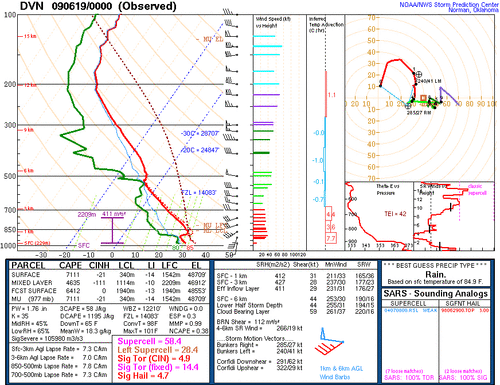
There have been plenty of events with both high shear and high CAPE that did absolutely nothing. I can think of numerous during June and July in the Midwest and Northern Plains. One of the bigger ones I can think of is June 18 2009 in Iowa. 15% hatched region for significant tornadoes along a warm front, insane shear/CAPE combination with maxed out parameters and nothing formed except a nocturnal supercell in Southwest Wisconsin. It gave for a great sunburn though! Here is the DVN sounding from that "event". Capping is usually a major concern with these setups. On the other spectrum, I've seen setups with maxed out soundings produce violent tornadoes (4/27/11 and 6/16/14 come to mind).
DVN_061909.gif
 
Sorry for reviving an old thread (I am new here and was looking over the old ones). Has there ever been a tornado outbreak that has had both high CAPE values and high shear both? Didn't the 1974 outbreak have both? And also the 2011 outbreak?

Conversely, I would assume that there has also been instances of both high CAPE and shear that have produced nothing or very little in the way of tornado events or severe storms?


I believe the Pilger twin EF4s formed in an environment with high CAPE and high shear.

From my experience, high shear low instability produces more often than high instability low shear. From a chasing perspective, high shear low instability set ups suck to chase because high shear usually means upper level winds are really strong and cause the storms to move faster than you can keep up with them. On the opposite end, high instability low shear storms are the slow moving storms that you can sit and watch without having to move much. Problem is the low shear can cause the downdraft to be too close to the updraft and the storm kills itself before it has a chance to do anything. Even if the storm is able to sustain itself, its usually in the form of an HP supercell because the upper level winds aren't strong enough to push the downdraft far enough downwind of the updraft.
 
Back
Top